

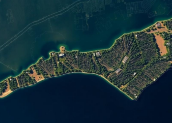
Satellites reveal accelerating ghost forest loss on North Carolina’s coast
A new PLOS One study using AI analysis of satellite imagery finds North Carolina lost 21 percent of its coastal ...
A new PLOS One study using AI analysis of satellite imagery finds North Carolina lost 21 percent of its coastal ...

A satellite-based analysis of Lucknow, India reveals residential land shortfalls of up to 41.68 percent across concentric zones around the ...
A two-decade Landsat analysis using image-specific NDVI thresholding reveals a net loss of 275 square kilometres of mapped vegetation in ...
A new study in Benin's Trois-Rivières Forest Reserve shows that ethnicity, age, and income shape how villagers perceive deforestation and ...
A 32-year satellite study combining remote sensing indices and multivariate statistics shows high-risk land degradation in India's Chambal region has ...
A three-decade Landsat analysis of Ara city, India, shows urban expansion significantly eroding vegetation and wetland health while reshaping the ...
A two-decade satellite analysis of Ibadan's peri-urban corridor reveals that urban expansion follows a predictable sequence from vegetation to bare ...
A two-decade machine-learning analysis of Landsat imagery shows vegetation cover in Malawi's Chia Lagoon catchment fell by 189 square kilometres ...
A thirty-year satellite and bathymetric analysis shows Bangladesh's Jamuna River eroded about 55,436 hectares while accreting 53,496 hectares, migrating eastward ...
A decade of satellite imagery and surveys shows Greater Kumasi lost nearly a third of its natural areas while most ...

Embark on a thrilling journey of discovery with Scienmag.com—your ultimate source for cutting-edge breakthroughs. Immerse yourself in a world where curiosity knows no limits and tomorrow’s possibilities become today’s reality!