

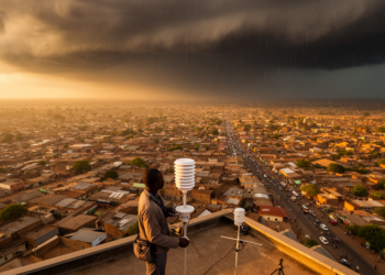
Africa’s fastest-growing cities remain the least studied for climate hazards
A review of 272 studies finds that research on climate hazards in African cities is expanding rapidly but remains skewed ...
A review of 272 studies finds that research on climate hazards in African cities is expanding rapidly but remains skewed ...

The study addressed a monitoring gap.
KAIST’s GeoCore-9B outperformed task-specific systems on key public-dataset measures for cloud removal and led some radar-to-optical conversion metrics.
A new global monthly groundwater dataset at 1 km resolution for 2002-2020 combines GRACE satellite gravity, environmental predictors and machine ...
A collaboration between an Italian art high school and CNR researchers shows how satellite imagery and environmental data can be ...
Researchers have developed a bottom-up method that uses free satellite data to map forest timber growth at 20-metre resolution, outperforming ...
A new study shows that free satellite data from Copernicus, Landsat, and fire-detection services have replaced a century of sparse ...
A systematic review of 57 studies defines Digital Twin Forestry as an emerging informatics paradigm that continuously couples multisensor Earth ...
A new Frontiers in Remote Sensing collection showcases polarimetric cloud imaging, cloud tomography, event-based lightning sensors, adaptive pointing strategies, and ...
Researchers in India have published a detailed mathematical blueprint for a spatio-temporal graph foundation model designed to learn continuously from ...

Embark on a thrilling journey of discovery with Scienmag.com—your ultimate source for cutting-edge breakthroughs. Immerse yourself in a world where curiosity knows no limits and tomorrow’s possibilities become today’s reality!