

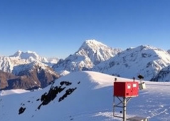
World’s Highest Weather Stations Reveal Everest’s Extreme Climate From Valley to Summit
A new open-access dataset from six automatic weather stations spanning 3,810 to 8,810 metres on Mount Everest reveals how temperature, ...
A new open-access dataset from six automatic weather stations spanning 3,810 to 8,810 metres on Mount Everest reveals how temperature, ...

Researchers at the University of Potsdam have developed OrthoSAM, an AI workflow that automatically delineates thousands of individual river pebbles ...
A new glacier flow model that tracks rock debris travelling inside ice shows that debris-covered glaciers ignore short-term climate swings ...
Researchers have mapped groundwater potential across Uttarakhand's rapidly urbanising Soar Valley using an integrated AHP-GIS framework validated against 91 spring ...
A new study along a landslide-ravaged stretch of National Highway 7 in Uttarakhand shows that Random Forest and XGBoost machine ...
Integrated thermokinematic and landscape modeling in western Nepal shows that Himalayan exhumation is driven by a northerly fault ramp beneath ...
A new grid-based Accumulated-Event Risk Indicator built from a decade of EM-DAT records identifies 14 global disaster hotspots concentrated in ...
A new AHP-based landslide susceptibility map of the Solan-Shimla highway in Himachal Pradesh identifies the most dangerous slopes along a ...
A household survey in Dehradun district, India, has documented 36 medicinal plant species used by the Jaunsari tribe, revealing how ...
Satellite radar, optical imagery and flood modelling reveal that the repeatedly reactivating Kuwari landslide in Uttarakhand has formed an unstable ...

Embark on a thrilling journey of discovery with Scienmag.com—your ultimate source for cutting-edge breakthroughs. Immerse yourself in a world where curiosity knows no limits and tomorrow’s possibilities become today’s reality!