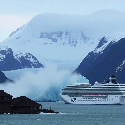
In August 2025, a dramatic natural event unfolded in the remote yet frequently visited Tracy Arm fjord in southeast Alaska, capturing the attention of the global scientific community. This event, a massive landslide plunging from steep mountainsides into the ocean, triggered a tsunami that surged an astonishing 481 meters—roughly one and a half times the height of the iconic Eiffel Tower—up the fjord’s opposite cliffs. This tsunami, one of the highest ever recorded, generated seismic waves comparable in magnitude to a 5.4 earthquake, revealing the tremendous forces at play when land and sea collide in such catastrophic fashion.
What makes this event particularly significant is not only its sheer scale but also its timing and location. Happening in the early pre-dawn hours around 5:30 a.m., the tsunami struck when human activity in the fjord was minimal, sparing lives despite the regular presence of some 20 cruise ships, kayakers, and other visitors who navigate this scenic but geologically volatile region. Tracy Arm is a renowned destination within the Tongass National Forest, located approximately 80 kilometers south of Juneau, Alaska, attracting tourists eager to glimpse the stunning glaciers and rugged mountain vistas.
A team of international researchers recently published an in-depth study in the prestigious journal Science, meticulously reconstructing this near-disaster from multiple angles, including eyewitness testimony, satellite imagery, and seismic data analysis. Dr. Dan Shugar, a geomorphologist and lead author affiliated with the University of Calgary, emphasizes the multi-faceted approach used to understand the dynamics of the landslide and resulting tsunami. Their work highlights the interplay between glacial retreat and destabilizing geological conditions along fjord walls.
Eyewitness accounts proved invaluable in this reconstruction. Kayakers in the fjord reported awakening to unexpectedly receding waters and swift currents sweeping away gear and even one kayak. Nearby, passengers aboard a cruise ship anchored close to the fjord’s mouth observed notable white water and currents but did not witness a conventional tsunami wave crest, underscoring the complex wave dynamics in narrow fjord environments. These firsthand observations, combined with satellite data, enabled the researchers to visually capture the event’s unfolding in unprecedented detail.
Central to the investigation was the utilization of novel satellite technologies, including data from the Surface Water Ocean Topography (SWOT) satellite, which allowed the team to observe and characterize the tsunami’s full sea surface structure remotely. Co-author Dr. Thomas Monahan from the University of Oxford highlights how these advanced observational tools are becoming increasingly vital, especially as hazards in the Arctic and other remote regions intensify amid climate change. This capability marks a significant advancement in monitoring remote disaster phenomena that previously went undocumented.
Surprisingly, the landslide and resulting tsunami occurred without the typical precursors often noted in such colossal rock avalanches. Dr. Shugar explains that prior to these events, the mountain slopes frequently exhibit noticeable slow movement, sagging, or other signs as their structure weakens over time. In this case, however, no such warning was evident—only minor seismic noise barely registering above background levels. This suddenness challenges traditional early-warning paradigms and complicates risk mitigation strategies in similarly vulnerable terrains.
The implications of this event extend beyond mere geological curiosity. The research points to accelerated glacier retreat as a critical driver in destabilizing mountainous slopes within this region. As climate change drives glacial ice loss and thinning, previously buttressed slopes become more susceptible to collapse, elevating the frequency and severity of landslide-generated tsunamis. This dynamic presents an urgent call for enhanced monitoring and preparedness in glaciated fjords globally, especially in areas where tourism and local communities intersect with these risks.
After the event, considerable attention turned toward revising safety protocols and travel routes in southeast Alaska. Several cruise lines have proactively altered their itineraries in 2026 to avoid high-risk zones within Tracy Arm fjord, reflecting a growing awareness of evolving natural hazards linked to environmental change. The U.S. Geological Survey has reinforced warnings regarding the inherent instability of steep, mountainous landscapes, emphasizing that shifts and changes can persist for years following a significant landslide.
The study also highlights the importance of integrating diverse scientific methodologies—field reconnaissance, satellite remote sensing, numerical modeling, and seismic analysis—to fully capture the multifaceted nature of such disasters. This comprehensive approach not only elucidates the mechanisms behind this particular event but also provides a framework for anticipating and responding to similar occurrences worldwide, where climate-driven geological hazards are emerging as pressing global concerns.
In conclusion, the remarkable 2025 Tracy Arm landslide-tsunami event offers vital insights into the interplay between geological processes and climate change, with significant implications for hazard risk management in coastal fjord environments. It underscores the unpredictable nature of sudden, large-scale natural disasters and the pressing need for improved surveillance and preparedness as glaciers retreat and reshape the landscape. Stakeholders—including governments, industry players, and local communities—are urged to heed these lessons to mitigate risks and protect lives in areas increasingly exposed to such dramatic environmental transformations.
Subject of Research: Not applicable
Article Title: A 481-meter-high landslide-tsunami in a cruise ship frequented Alaska fjord
News Publication Date: 6-May-2026
Web References: 10.1126/science.aec3187
References: Published in Science journal
Image Credits: Photo by Cyrus Read/U.S. Geological Survey
Keywords: Alaska landslide, tsunami, Tracy Arm fjord, glacier retreat, seismic event, Surface Water Ocean Topography, climate change hazards, fjord geology, natural disaster monitoring
