In a groundbreaking study published in Environmental Earth Sciences, researchers A.İ. Karabulut and M.İ. Yeşilnacar have unveiled a comprehensive analysis of asbestos-related environmental hazards in Southeastern Anatolia, Türkiye, harnessing the combined prowess of Geographic Information Systems (GIS) and advanced remote sensing technologies. This pioneering approach sheds unprecedented light on the spatial distribution and intensity of asbestos contamination in a region historically understudied, revealing risks that extend beyond traditional boundaries and demanding urgent scientific and public health attention.
Asbestos, a naturally occurring mineral once lauded for its fire-resistant properties, has long been recognized as a silent threat to human health. When asbestos fibers become airborne and inhaled, they can lead to severe respiratory conditions, including asbestosis, lung cancer, and mesothelioma. The environmental implications of asbestos are equally dire, considering its persistence and mobility in soil and water systems. Karabulut and Yeşilnacar’s study meticulously maps these dangers by employing cutting-edge spatial analytical techniques that integrate field data with multispectral satellite imagery, enabling precise delineation of asbestos-contaminated zones across diverse terrains.
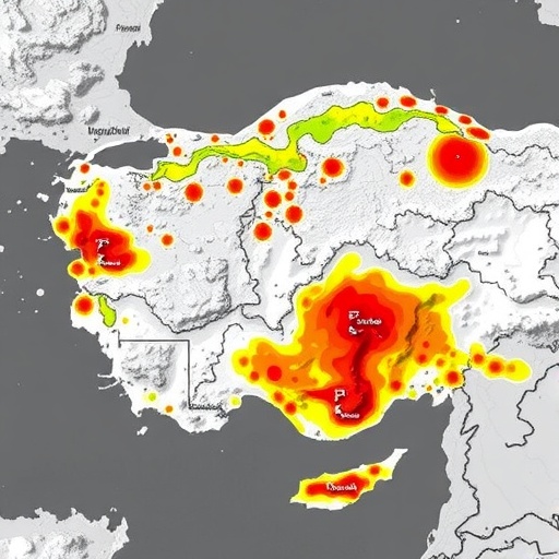
The researchers adopted a multi-tiered methodological framework aimed at isolating areas with elevated asbestos presence. Initially, high-resolution satellite images were processed to detect distinct spectral signatures indicative of asbestos-bearing mineral assemblages. These remote sensing datasets were then fused with GIS layers that encompassed topographical attributes, land use maps, and known geological formations predisposed to harbor asbestos minerals. The fusion of diverse spatial data allowed the team to create robust contamination risk models that visualize hotspots where human and ecological exposure is maximized.
One of the most compelling aspects of this research is its ability to transcend the limitations of traditional asbestos investigations, which often rely on sporadic ground sampling. The integration of remote sensing affords vast spatial coverage and the ability to monitor inaccessible or hazardous areas, turning what was once a painstakingly slow process into a dynamic, scalable surveillance technique. This advancement marks a paradigm shift in environmental risk assessment, underscoring the strategic value of technological innovation in confronting legacy pollutants.
The spatial patterns uncovered by the study reveal a complex biogeochemical interplay contributing to asbestos dispersion. Regions characterized by rugged mountainous terrains and exposed ultramafic rocks emerged as primary sources of asbestos-bearing fibers. Furthermore, erosional processes, exacerbated by seasonal rains and human activities such as quarrying and construction, were identified as mechanisms mobilizing asbestos fibers into adjacent soil and water systems. These insights spotlight the multifaceted nature of environmental asbestos risk, involving both natural and anthropogenic factors.
Importantly, the research services a dual purpose: it not only identifies environmental risks but also serves as a proactive tool for land use planning and public health safeguarding. By integrating the GIS-based risk maps with demographic data, policymakers can pinpoint vulnerable communities, strategize intervention priorities, and design targeted educational campaigns to mitigate exposure. This intersection of environmental science and public policy could herald a new era of data-informed governance, emphasizing prevention alongside remediation.
The remote sensing analysis utilized in this study relied heavily on spectral bands sensitive to the unique reflectance properties of asbestos minerals. Utilizing sensors equipped for shortwave infrared (SWIR) imaging, the researchers effectively isolated spectral anomalies correlating with chrysotile and amphibole asbestos types. These mineralogical signatures, often obscured by vegetation or soil cover in visible spectra, became retrievable through multispectral enhancement and principal component analysis. This technical achievement underscores the nuanced complexity of parsing mineral signatures from satellite data in heterogeneous landscapes.
Beyond identification, the study delves into temporal dynamics, examining how environmental asbestos distribution fluctuates seasonally. It was observed that fiber dispersal intensifies during dry seasons when vegetation cover is minimal, and wind erosion is at its peak, enhancing aerosolization of asbestos particles. Conversely, wet seasons suppress airborne fiber mobilization but increase aqueous transport, thereby contaminating water bodies downstream. These seasonal oscillations have profound implications for timing public health advisories and remediation efforts, necessitating adaptable management strategies.
Intriguingly, the spatial risk models developed by Karabulut and Yeşilnacar also incorporate socio-economic variables that intersect with environmental exposure. Regions with higher construction activity showed elevated disturbance of natural asbestos reservoirs, reflecting the unintended consequences of rapid urbanization and industrial expansion. This linkage highlights the imperative for integrating environmental risk assessments with urban development plans to prevent exacerbation of asbestos-related hazards in burgeoning communities.
The implications of this research are not confined to Southeastern Anatolia. Globally, many regions with geological arsenals of asbestos minerals face similar threats, often compounded by limited monitoring resources. The methodological blueprint presented in this study serves as a replicable model for other at-risk geographies, especially in developing nations where environmental health infrastructures may be nascent. By democratizing access to remote sensing data and GIS analytical tools, this approach empowers stakeholders worldwide to confront asbestos pollution proactively.
Moreover, the use of GIS in environmental science has evolved far beyond mere mapping to become a predictive and integrative platform that synthesizes multifactorial data streams. This study exemplifies such progression by incorporating geological, climatic, and anthropogenic datasets into geostatistical models, generating actionable risk assessments rather than static observations. The enhanced granularity and precision achieved through this technical fusion elevate environmental risk management into an anticipatory science, capable of informing early warning systems and emergency preparedness.
Critically, Karabulut and Yeşilnacar address the nuanced obstacles encountered in remote sensing applications for asbestos detection, including spectral confusion with other silicate minerals and interference from atmospheric conditions. Through rigorous calibration and validation against ground-truth samples, the accuracy of the risk maps was substantiated, marking a substantial advance over previous efforts relying solely on in situ observations. The transparent articulation of methodological challenges enhances the robustness and credibility of their findings, reinforcing confidence in the proposed surveillance framework.
The study also underscores the durable legacy of asbestos in the environment — decades after widespread restrictions were imposed, the mineral continues to pose a propagating hazard. Natural weathering processes liberate asbestos fibers into new environmental compartments, perpetuating exposure risks indefinitely. This lingering threat necessitates continuous monitoring and adaptive management, which can be effectively supported by the GIS and remote sensing infrastructure advocated here.
In terms of future directions, the researchers propose expanding this methodology by integrating hyperspectral imaging and LiDAR data to enhance mineral detection accuracy and elevation modeling. Such integration would refine the three-dimensional mapping of asbestos deposits, providing deeper insights into subsurface distributions and potential migration pathways. Additionally, coupling these spatial approaches with epidemiological data could elucidate direct correlations between environmental asbestos presence and health outcomes, closing the loop between environmental science and public health.
This study arrives at a critical juncture when global awareness of environmental pollutants is surging, and technological capabilities are rapidly advancing. By pioneering a methodical, technology-driven approach to asbestos risk assessment, Karabulut and Yeşilnacar not only elevate scientific understanding but also carve pathways toward pragmatic solutions that protect vulnerable ecosystems and populations. Their work exemplifies the transformative potential of interdisciplinary research in addressing complex environmental health challenges.
From a broader perspective, this research galvanizes the scientific community to revisit legacy pollutants with renewed rigor and innovation. It signals a shift from reactive pollutant management toward predictive, data-driven environmental stewardship. By harnessing the synergy of GIS and remote sensing, it becomes feasible to transcend conventional monitoring limitations, achieving holistic, dynamic assessments that resonate with contemporary demands for sustainable and healthy environments.
As such, the insights delivered through this study are poised to reverberate far beyond Southeastern Anatolia. They echo a universal call to action: that modern technologies must be harnessed innovatively to unearth hidden environmental risks, safeguard human health, and steward fragile ecosystems amidst growing anthropogenic pressures. In this quest, Karabulut and Yeşilnacar’s work stands as both a beacon and blueprint.
Subject of Research: Asbestos-related environmental risks in Southeastern Anatolia, Türkiye, analyzed via GIS and remote sensing.
Article Title: Investigation of asbestos-related environmental risks using GIS and remote sensing in Southeastern Anatolia, Türkiye.
Article References:
Karabulut, A.İ., Yeşilnacar, M.İ. Investigation of asbestos-related environmental risks using GIS and remote sensing in Southeastern Anatolia, Türkiye. Environ Earth Sci 84, 497 (2025). https://doi.org/10.1007/s12665-025-12489-6
Image Credits: AI Generated
