

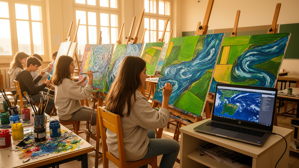
In a small art high school in the southern Italian town of Melfi, twenty-seven teenagers spent the 2024–2025 school year doing something unusual for art students: they learned to read satellite imagery, handle geospatial data, and then transformed what they saw into paintings, architectural visualizations, and digital animations. The project, called “Through the Kaleidoscopic Lens of Art: Imaging the Environment,” was a collaboration between the Art High School “Mario Festa Campanile” and researchers from the Institute of Methodologies for Environmental Analysis of Italy’s National Research Council (IMIOT-CNR). A new study published in Frontiers in Education documents the entire science-to-art pathway, offering one of the most detailed descriptions yet of how Earth observation data can flow from research laboratories into the hands of high school artists.
The initiative took place within Italy’s PCTO framework—Percorsi per le Competenze Trasversali e l’Orientamento, or Pathways for Transversal Skills and Career Guidance—a national program established by the 2015 education reform “La Buona Scuola” and recently redefined as FSL, School-Work Training. PCTO requires upper-secondary students to alternate classroom instruction with hands-on professional experiences, encouraging collaboration among schools, universities, and research institutions. In this case, the collaboration paired CNR researchers who study environmental processes with art teachers who guide students in painting, design, and multimedia production. The result was a roughly 34-hour pathway combining 16 hours of scientific instruction, 6 hours of field and laboratory activities, and 12 hours of creative workshops.
The scientific component was ambitious in scope. CNR researchers introduced the students to the Anthropocene and its environmental implications, geophysical methods for studying soil, subsoil, and groundwater, satellite monitoring of land, air, and water quality, urban growth and natural hazards in the Mediterranean basin, and the data platforms used for Earth Observation. The lessons were not purely theoretical. Students participated in a field measurement campaign, observing how environmental data are acquired in real time under expert supervision, and visited the institute’s geophysical laboratory and the CIAO Atmospheric Observatory, with particular attention to its ACTRIS–CCRES component dedicated to cloud remote sensing. The thematic breadth covered soil, subsoil, vegetation, water, and air, supporting what the authors describe as a holistic understanding of socio-ecological systems.
Despite the range of topics, the project converged on a single unifying medium: the satellite image. The researchers identified satellite imagery as an effective bridge between scientific observation and artistic expression, and the practical work progressively focused on its reinterpretation. Students learned basic data visualization and processing using freely accessible geospatial platforms, primarily Google Earth, alongside graphic-design software including Adobe Photoshop. They examined landscape interpretation and the critical reading of satellite products, and then searched independently for additional imagery, guided by the examples and data sources the researchers had presented. The creative brief addressed processes such as soil degradation, urban expansion, atmospheric pollution, biodiversity loss, and water quality.
The creative process unfolded in three distinct phases. First came scientific contextualization and visual observation, in which students studied satellite images of Earth to identify patterns, chromatic variations, textures, and signs of human activity. Second was conceptualization and re-elaboration, during which students selected visual elements from the scientific materials and reinterpreted them through experimentation, abstraction, and discipline-specific modes of representation. Third was technical execution, in which the selected elements were translated into completed works according to the methods of each artistic track. The project produced eleven completed artworks, all of which were examined in the study.
The comparison across the school’s three artistic tracks revealed something striking: identical scientific source materials generated fundamentally different modes of translation. Students in the Figurative Arts track—five students in total—produced mixed-media paintings combining acrylic paint with epoxy resin. The resin pouring technique created a glossy, three-dimensional “liquid glass” effect, with saturated colors forming random shapes that evoke the complex, corrosive textures left by environmental pollution. The acrylic’s quick-drying properties prevented it from mixing with the resin, allowing the transparent protective layer to deepen the colors beneath. The researchers characterize this approach as material and chromatic abstraction, retaining references to environmental processes while opening space for subjective interpretation.
The Architecture and Environment track, with eleven students, took a spatial and scalar approach. These students transformed landscape morphology, topography, and spatial patterns into graphic and material compositions, working with contour lines, landscape textures, and top-down views of buildings. Some works integrated top-down architectural views directly into landscape maps, transforming buildings from mere constructions into forms that occupy and modify the terrain’s visual composition. In a particularly inventive move, other works applied satellite image textures onto building façades, merging the macro-scale perspective of Earth Observation with the micro-scale of architectural detail—effectively turning façades into geographical canvases onto which planetary processes are projected. One work went further, coating contour-line representations with real building materials, literally giving physical substance to topography and symbolizing the fragmentation and re-composition of landscape through human intervention.
The Audiovisual and Multimedia track, also with eleven students, pursued digital and narrative re-composition. Using Adobe Photoshop and Adobe InDesign, they created photomontages through layering, color alteration, filtering, and re-composition, transforming recognizable landscape features from satellite imagery into digital narratives of environmental change. The original images served both as source material and as a metaphor for a changing planet. The researchers note that digital tools functioned here not merely as instruments of technical execution but as vehicles for conceptual exploration and environmental narration, with the resulting works including animations and audiovisual products depicting planetary movement and human impact.
The eleven works were publicly exhibited under the title “COSMOS CREATIVO: Artistic Transformations of Earth from Space” during the “SuperScienceMe—ReSearch is your Elevation” event of the European Researchers’ Night on 28 March 2025. By moving the artworks from the educational setting into a public exhibition, the pathway extended from artistic production into environmental communication, positioning the works as interfaces between environmental science, artistic expression, and public interpretation. The authors are careful to note that audience responses were not collected through a systematic research protocol and are not analyzed as study data, and that two brief student interviews included in a project documentation video are presented only as anecdotal micro-feedback rather than a structured assessment of the whole cohort.
The study’s broader significance lies in what it reveals about the science-to-art translation itself. The authors argue that the translation from science to art is not a uniform process: the characteristics of each artistic practice influence which elements of scientific representations are selected, emphasized, transformed, and communicated. Scientific representations are accountable to evidence and methodological transparency, whereas artistic practices can employ abstraction, metaphor, material transformation, and emotional resonance—and within the PCTO framework, these different representational logics were brought into interaction while retaining their disciplinary specificity. For educators designing similar activities, the implication is that the choice of artistic practice should be considered alongside the selection of scientific source materials and the intended environmental focus, since a common source image need not lead to a uniform output. The authors frame the pathway as a context-dependent framework to be adapted rather than directly replicated, noting that openly accessible Earth Observation datasets, including those from Copernicus data portals, and commonly available software could facilitate adoption elsewhere. Future implementations could extend the model through travelling exhibitions, citizen-science activities, immersive virtual and augmented reality technologies, and collaborations with organizations such as ESA and NASA—though the authors stress that systematic evaluations of learning outcomes and audience responses remain a necessary next step for this emerging intersection of remote sensing, creativity, and environmental education.
Subject of Research: A STEAM education project integrating satellite imagery and environmental data into art production within Italy's PCTO framework
Article Title: Through the Kaleidoscopic Lens of Art: a STEM education pathway within Italy’s PCTO framework
Article References: Coluzzi, R., Imbrenda, V., Fanti, L., Traino, W., De Carlo, M., Camardelli, V., Smilzo, A., Cordisco, M., Limone, G., Amato, L., Calamita, G., Ciancia, E., Gandolfi, I., Perrone, A., Lucente, S., & Giampaolo, V. (2026). Through the Kaleidoscopic Lens of Art: a STEM education pathway within Italy’s PCTO framework. Frontiers in Education, 11, Article 1922875. https://doi.org/10.3389/feduc.2026.1922875
Image Credits: AI Generated
DOI: 10.3389/feduc.2026.1922875
Keywords: STEAM education, satellite imagery, Earth observation, PCTO, environmental communication, remote sensing, art high school, interdisciplinary learning, geospatial data, environmental awareness, Italy, science-to-art
Cite Scienmag News
Cora Reilly. (October 17, 2026). Satellite Images Become Art as Italian Students Turn Earth Data Into Paintings. Scienmag. https://scienmag.com/satellite-images-become-art-as-italian-students-turn-earth-data-into-paintings/
Cora Reilly. "Satellite Images Become Art as Italian Students Turn Earth Data Into Paintings." Scienmag, 17 October 2026, https://scienmag.com/satellite-images-become-art-as-italian-students-turn-earth-data-into-paintings/. Accessed 17 October 2026.
Cora Reilly. "Satellite Images Become Art as Italian Students Turn Earth Data Into Paintings." Scienmag. October 17, 2026. https://scienmag.com/satellite-images-become-art-as-italian-students-turn-earth-data-into-paintings/


