

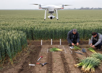
Fused UAV data improve winter wheat biomass estimates in two-season field study
A two-season Chinese field study found that fused UAV spectral, texture, LiDAR and temporal features with random forest produced the ...
A two-season Chinese field study found that fused UAV spectral, texture, LiDAR and temporal features with random forest produced the ...

A study of six hectares of Chinese transition-zone forest finds that ectomycorrhizal tree dominance strongly predicts higher aboveground biomass while ...
A large-scale survey of 306 sites on the Mongolian Plateau shows that a community-wide trade-off between leaf hydraulic efficiency and ...
By fusing spaceborne LiDAR, radar and optical satellite data with field plots, researchers have produced high-resolution canopy height and biomass ...
A new study shows that Sentinel-2 satellite NDVI can estimate mangrove aboveground biomass and carbon stocks in Indonesia's Pangpang Bay, ...
An open-source QGIS plugin called GEDIMetrics now automates the discovery, filtering, and fusion of NASA's GEDI spaceborne LiDAR products, making ...
A field trial in arid sandy land shows that mixing crushed alfalfa and ryegrass residues into topsoil slows infiltration, curbs ...
A satellite and machine learning study finds Southeast Asia lost about 59 percent of its intact forests between 2000 and ...
A new deep learning and ensemble learning framework reaches up to 93.04% accuracy in estimating aboveground biomass across three contrasting ...

Embark on a thrilling journey of discovery with Scienmag.com—your ultimate source for cutting-edge breakthroughs. Immerse yourself in a world where curiosity knows no limits and tomorrow’s possibilities become today’s reality!