


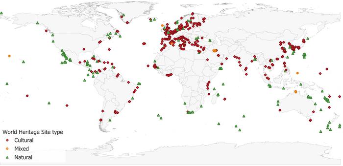
A new digital mapping project aims to protect coastal UNESCO World Heritage sites from intensifying sea-level rise, flooding, and coastal erosion. The effort delivers a first-of-its-kind, comprehensive spatial database focused on places that sit in low-lying coastal zones—less than 20 metres above sea level—where climate impacts are often hardest to quantify.
The Global Coastal Heritage (Glo-CoH) dataset was created by an international research team led by scientists from the University of East Anglia (UEA), Durham University, and the University of Cape Town. Motivated by urgent concerns about how coastal development and climate change threaten both cultural and natural treasures, the project turns historical records and satellite observations into usable digital boundaries.
Published in Scientific Data, the resource provides precise mapped outlines for every UNESCO World Heritage property of “Outstanding Universal Value” located along coastlines worldwide. The mapping is based on the UNESCO World Heritage list as of 2023, with an update planned through 2026 by the end of this year to keep the catalogue current.
In total, the dataset includes 1,250 individual heritage sites. These span cultural monuments, ecosystems of natural significance, geodiversity and rare species habitats, and mixed heritage locations that combine both cultural and natural values. Together, the mapped sites cover more than 235 million hectares, illustrating the geographic scale of what is at stake.
Until now, researchers have struggled to model hazard exposure accurately because detailed boundary maps were often unavailable. By supplying digitised spatial limits, Glo-CoH enables more reliable assessments of storm surge effects, coastal flooding, and erosion risks across local, regional, and global planning scales.
To build the maps, the team traced each site boundary using published site plans and cross-referenced them with Google Earth satellite imagery. This approach was supported by a structured quality-checking process that evaluated source-material quality, correct site identification, and digitisation precision.
The authors report that the mapping achieved high reliability: 92% of sites reached the top levels of digitisation accuracy. Such performance is designed to support real risk assessment rather than high-level approximation.
Researchers say the dataset is already being used to power follow-on studies, including a global sea-level risk analysis of coastal heritage sites and a climate-risk assessment for biodiversity at these locations, with an emphasis on thermal exposure affecting reef-building corals and mangroves.
The work was funded by Irish Aid, the British Academy, and the UK Natural Environment Research Council, and is published under the title “Mapping the global distribution of coastal World Heritage Sites: Glo-CoH, a new Global Coastal Heritage dataset.” As sea levels continue to rise, the team argues that accessible, high-precision spatial data can help guide conservation decisions before irreversible loss occurs.
Cite Scienmag News
Courtney Benton. (July 27, 2026). Mapping Project Helps Shield Coastal World Heritage Sites From Climate Risks. Scienmag. https://scienmag.com/mapping-project-helps-shield-coastal-world-heritage-sites-from-climate-risks/
Courtney Benton. "Mapping Project Helps Shield Coastal World Heritage Sites From Climate Risks." Scienmag, 27 July 2026, https://scienmag.com/mapping-project-helps-shield-coastal-world-heritage-sites-from-climate-risks/. Accessed 4 September 2026.
Courtney Benton. "Mapping Project Helps Shield Coastal World Heritage Sites From Climate Risks." Scienmag. July 27, 2026. https://scienmag.com/mapping-project-helps-shield-coastal-world-heritage-sites-from-climate-risks/


