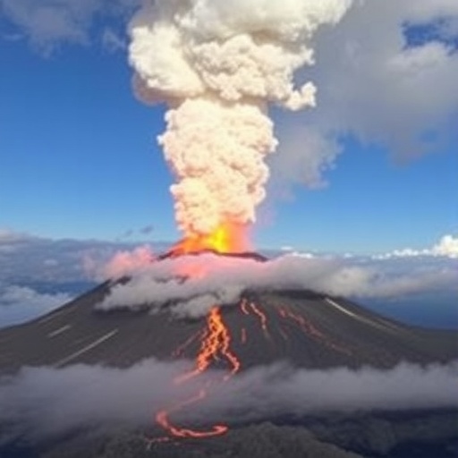
In late 2022, the Mauna Loa volcano erupted, sending molten lava racing toward Daniel K. Inouye State Highway 200, commonly known as Saddle Road. This highway serves as a vital artery for residents commuting between home and work on either side of Hawaii’s Big Island. The eruption posed a significant threat to this crucial route, igniting concerns about whether the lava flow would ultimately sever this lifeline or halt its advance before causing damage. At the time, forecasting the lava’s trajectory and speed was fraught with uncertainty, leaving communities and authorities on edge.
Advancements in satellite technology and computational methods now promise to transform volcanic monitoring by enabling real-time, precise mapping of lava flows and early eruption predictions. These breakthroughs are the outcome of interdisciplinary collaboration spearheaded by researchers from the University of Pittsburgh, tapping into a trove of satellite data streams from both public and private platforms. By fusing these datasets and applying innovative machine learning algorithms, scientists have developed tools that can not only track eruption dynamics as they unfold but also predict concealed eruptions by detecting subtle precursors.
Among the satellites employed in this endeavor are the Planet SuperDoves—a constellation of small, privately operated satellites—alongside established government assets such as Landsat 8 and Sentinel 2. Together, these platforms provide high-resolution, frequent imaging that captures the evolution of lava flows with remarkable detail and temporal precision. Importantly, the integration of diverse satellite resources improves resilience in monitoring capabilities, ensuring continuous observation even under challenging weather or daylight conditions. A baseline greyscale hillshade image derived from pre-eruption elevation data further contextualizes lava movement across complex terrain.
During the critical 13-day eruption period, Professor Ian Flynn and his team leveraged these satellite feeds to monitor Mauna Loa’s channelized lava flows in near real-time. They meticulously mapped the advancing lava front’s position, noting its progression towards the Saddle Road but crucially documenting its cessation approximately 1.5 miles before reaching the pavement. This granular spatial-temporal insight proved indispensable for hazard assessment, enabling emergency responders to calibrate risk and prioritize resource deployment with unprecedented accuracy.
Central to enhancing eruption forecasts was the incorporation of machine learning techniques to extract meaningful signals from voluminous satellite thermal data. Collaborating with volcanologist Dr. Claudia Corradino from Italy’s National Institute of Geophysics and Volcanology, the team identified a significant thermal anomaly roughly a month prior to the eruption onset. This early thermal rise, discernable only through advanced algorithmic analysis, offers a promising window into the precursory phases of volcanic activity—information vital for timely warnings and evacuation planning.
Beyond tracking the lava’s surface footprint and thermal characteristics, the researchers sought to understand the vertical dimension—lava flow thickness—which is crucial for assessing eruption intensity and volume emission rates. To achieve this, Professor Flynn partnered with Dr. Shashank Bhushan from NASA’s Goddard Space Flight Center, adapting methodologies previously developed for estimating glacier thickness via satellite remote sensing. This novel cross-disciplinary approach enabled the team to generate three-dimensional lava flow models, shedding light on eruptive vigor and material discharge that mere surface mapping cannot reveal.
Assessing lava flow thickness and cooling dynamics adds depth to interpretations of volcanic hazards. Hot, thick flows imply ongoing eruptive activity and toxic gas emissions, demanding continued vigilance. Conversely, cooling trends signal waning activity and safer conditions for scientific analysis or public access. These thermal and morphological metrics combined offer a holistic view of eruption lifecycle stages, empowering volcanologists to differentiate between nascent, peak, and declining eruptive episodes in near real-time.
The implications of this research extend beyond terrestrial volcanoes. Understanding how lava cools and solidifies under Earth-like conditions informs interpretations of remote sensing data from extraterrestrial volcanic bodies such as those on Venus. Planetary volcanologists can better constrain models of eruption timing, composition, and flow dynamics on other worlds by benchmarking against Earth’s well-characterized lava cooling regimes. This cross-planetary insight enriches our comprehension of planetary geology and volcanic processes in diverse environments.
No two volcanoes behave identically; each follows a unique “personality” shaped by geology, magma composition, structural controls, and local climate. The methodologies refined on Mauna Loa could thus serve as a template for tailored monitoring systems for other volcanoes worldwide, combining multispectral satellite data with bespoke machine learning analytics. Such customized, site-specific vigilance holds promise to significantly bolster volcanic risk mitigation globally, adapting to the nuances of individual volcanic behavior.
The success of this satellite data synergy embodies a paradigm shift in volcano monitoring, blending high-cadence remote sensing with sophisticated computational modeling. This integrative approach empowers researchers to anticipate eruptions earlier, understand eruption dynamics deeper, and communicate hazards more effectively. As satellite constellations continue to expand and computational capabilities grow, the horizon for volcanology is brightened by a future where eruptions can be mapped, understood, and forecast with unprecedented clarity.
Mauna Loa, arguably the most active volcano on Earth, remains a natural laboratory where these advancements are being tested and refined. As more eruptions occur and additional satellites become operational, scientists will continuously amass data to deepen their understanding of volcanic systems. This iterative learning approach not only improves hazard predictions on the Big Island but also lays groundwork for developing forecasting tools adaptable to the unique behaviors of volcanoes across the globe.
Ultimately, the union of satellite technology, machine learning, and interdisciplinary collaboration heralds a new era in volcanic science—one where the unpredictable becomes increasingly knowable. This progress promises safer communities, more resilient infrastructure, and a richer understanding of one of nature’s most powerful and mesmerizing forces.
Subject of Research:
Not applicable
Article Title:
Satellite data synergy for volcano monitoring: The 2022 Mauna Loa eruption
News Publication Date:
22-Mar-2026
Web References:
http://dx.doi.org/10.1016/j.jvolgeores.2026.108603
Image Credits:
Courtesy of Ian Flynn/University of Pittsburgh
Keywords
Mauna Loa, lava flow, volcano monitoring, satellite remote sensing, machine learning, Planet SuperDoves, Landsat 8, Sentinel 2, eruption prediction, lava thickness, thermal infrared, volcanic hazard, planetary volcanology
