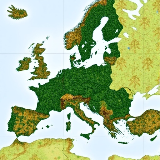
The latest installment of the ForestTalks webinar series, held on 23 February 2026, showcased groundbreaking advancements in integrating Earth observation (EO) data with National Forest Inventories (NFI) to enhance forest monitoring and greenhouse gas inventory reporting across Europe. This collaborative event was jointly organized by three leading projects—ForestNavigator, ForestPaths, and PathFinder—which unite experts from remote sensing, ecological modeling, and national reporting domains to address one of the most pressing environmental challenges of our time: accurately quantifying forest carbon dynamics at multiple scales. The webinar drew an interdisciplinary audience, including researchers, policymakers, and forest management professionals eager to leverage emerging technologies and datasets in pursuit of robust and harmonized climate action frameworks.
In the initial segment, Martin Herold from the German Research Centre for Geosciences (GFZ), representing the ForestNavigator project, illuminated the integration potential of the European Forest Disturbance Atlas (EFDA)—a pioneering, Landsat-based dataset providing consistent, long-term records of forest disturbances across the continent. He expounded on the methodological fusion of EFDA data with national-scale NFI statistics, emphasizing how combined remote sensing and ground-based approaches can substantially improve forest carbon stock assessments and greenhouse gas emissions reporting under the EU LULUCF (Land Use, Land-Use Change, and Forestry) framework. However, Herold also underscored the heterogeneity among European nations, revealing that no singular methodology applies seamlessly across diverse national forest contexts, thereby mandating tailored strategies to account for unique ecological and socio-economic conditions.
Kevin Black from the Forest Ecosystem Research Services (FERS) then presented the Irish case study, which highlighted severe limitations in relying solely on Landsat-based EFDA products for detecting harvest and disturbance events. Ireland’s landscape, characterized by fragmented forest patches, small-scale clear-fells, and frequent cloud obstruction, significantly hampers optical satellite data reliability. To address this, preliminary results from Sentinel-1 synthetic aperture radar (SAR) data were introduced, illustrating a remarkable three to sevenfold increase in detecting harvest activities relative to traditional EFDA references. This promising enhancement in harvest detection signals a paradigm shift, yet Dr. Black cautioned that comprehensive validation is necessary to establish operational confidence given the complexity of radar backscatter interpretation within heterogeneous forestry environments.
Shifting focus to Italy, Roberto Pilli illuminated the challenges of consistent national harvest statistics, where disparate sources report widely varying values. He championed an integrative approach whereby NFI field measurements, EFDA disturbance time series, and regionally calibrated models are fused to produce more accurate and reconcilable estimates of forest carbon fluxes. This multifaceted methodology addresses inconsistencies by leveraging diverse data types and spatial-temporal resolutions to triangulate carbon stock changes, facilitating improved transparency and comparability in reporting. Dr. Pilli’s work underscores the critical importance of harmonizing data streams to underpin robust national greenhouse gas inventories within complex, data-rich European forestry settings.
Emil Cienciala of the Institute of Forest Ecosystem Research (IFER) tackled the Czech Republic’s extraordinary scenario of a massive bark beetle outbreak that caused sanitary logging rates to spike to five times their historical levels. Despite this severe disturbance episode, EFDA disturbance maps and Carbon Budget Model (CBM) estimates demonstrated strong spatial congruence when evaluated across 14 NUTS 3 administrative regions, especially after excluding thinning activities. This alignment underscores the promising potential of high-resolution EO data coupled with process-based modeling to capture acute ecological events and their ramifications on carbon dynamics, thereby bolstering confidence in EO-based forest monitoring methodologies even amid exceptional disturbance regimes.
Expanding from national scopes to a continental perspective, Thomas Pugh of Lund University presented an innovative large-scale carbon balance analysis involving twelve EU member states. Utilizing the dynamic vegetation model LPJ-GUESS, his study integrated EFDA-derived disturbance data and NFI statistics to elucidate trends in forest carbon sinks over the past decade. The comprehensive modeling effort revealed a troubling trajectory: European forests’ carbon sequestration capacity is trending toward neutrality, eroding a vital natural climate mitigation service. Temporal variability was notably impacted by climatic extremes such as the 2018 drought, which diminished net primary productivity in Poland, Germany, and southern Sweden, and biotic disturbances like the bark beetle outbreaks in Germany and the Czech Republic during 2020. Furthermore, elevated respiratory fluxes in Northern European forests during 2023 contributed to this flux variability. These findings spotlight the increasing vulnerability of forest carbon sinks to climatological and ecological perturbations, underscoring the critical need for dynamic monitoring systems capable of capturing rapid, interannual changes to inform adaptive policy and management.
Addressing the necessity for standardized reporting tools, Murali Toppil from the University of Bristol delineated ongoing work within the PathFinder project to establish a harmonized EU LULUCF reporting framework. The initiative focuses on transforming high-resolution spatial maps and dynamic model outputs into structures compliant with regulatory reporting protocols, mitigating prevalent inconsistencies that currently obstruct cross-country comparability. He introduced projections derived from four distinct forest management scenarios, which uniformly forecast a decline in above-ground biomass stocks driven by factors including forest maturation, intensified harvesting, and climatic stressors. Notably, soil carbon reservoirs exhibited more pronounced losses under scenarios invoking intensive management. The freely accessible spatial datasets and model outputs serve as a pragmatic foundation empowering policymakers and scientists striving to align forest management strategies with the European Green Deal’s ambitious climate neutrality and biodiversity objectives.
The collective insights from the webinar underscore an unequivocal message: no single data source, whether remote sensing or field-based, can independently fulfill the demands of precise, reliable forest carbon monitoring. Instead, an integrated framework leveraging the complementary strengths of NFIs, EO-based disturbance products, and national statistics is paramount. The EFDA remains a cornerstone EO dataset valued for its pan-European applicability and robust historical depth, yet emerging Sentinel radar data offer finer spatial resolution and near-real-time monitoring capabilities, especially pertinent in landscapes where optical data sources suffer from persistent cloud cover or small-scale disturbance patterns. This integrative paradigm shift heralds a transformative leap forward, facilitating more nuanced, timely, and scalable forest carbon assessments essential for meeting evolving climate governance needs.
The webinar’s rich content, featuring country-specific case studies, advanced modeling techniques, and harmonized reporting initiatives, presents the scientific community with a multifaceted toolkit. It situates EO-enabled forest monitoring as a linchpin in operational climate change mitigation strategies, enabling better detection of disturbance events, quantification of carbon exchange, and projection of future trajectories under varied management regimes. By bridging technological innovation with policy-relevant outputs, the ForestTalks series advances a vision of informed stewardship that is holistically grounded in quantitative rigor and adaptive capacity—hallmarks necessary for safeguarding Europe’s forest ecosystems amid rapid environmental change.
All editions of the ForestTalks webinar series, including this revealing third installment, are available for public viewing on the Forest Paths project website as well as the YouTube channels of PathFinder and ForestNavigator. These resources provide invaluable knowledge dissemination channels for the global research community and stakeholders interested in the nexus of remote sensing, ecological modeling, and forest policy. The research efforts underpinning these advances have been generously supported by the European Union’s Horizon Europe Research and Innovation Programme under respective grant agreements assigned to ForestNavigator, ForestPaths, and PathFinder, alongside United Kingdom Research and Innovation Council backing for ForestPaths. These collaborations exemplify the essential role of coordinated funding and international partnerships in tackling complex environmental challenges with cutting-edge science.
In sum, the ForestTalks webinar series embodies a dynamic, forward-looking platform demonstrating how integrating multi-source EO data with ground observations and modeling frameworks can revolutionize forest carbon monitoring at multiple scales. It affirms that resolving the challenges of forest carbon accounting in Europe—and by extension globally—hinges on sophisticated, interoperable data ecosystems capable of reconciling diverse forest conditions and disturbance regimes. As evidence mounts on European forests’ shifting role from carbon sinks toward neutrality due to mounting pressures, the imperative for precision and adaptability in monitoring frameworks could not be greater. The innovative approaches spotlighted in this event set a robust foundation for future advances, ultimately supporting science-based policies that can sustain forest contributions to climate mitigation and biodiversity conservation.
Subject of Research: Integration of Earth observation data and National Forest Inventories for enhanced forest carbon monitoring and greenhouse gas reporting in Europe
Article Title: ForestTalks webinar unites cutting-edge Earth observation and national inventories to revolutionize European forest carbon monitoring
News Publication Date: 23 February 2026
Web References:
- ForestNavigator: https://www.forestnavigator.eu/
- ForestPaths: https://forestpaths.eu/
- PathFinder: https://pathfinder-heu.eu/
- European Forest Disturbance Atlas (EFDA): https://zenodo.org/records/13333034
- ForestPaths LPJ-GUESS Model: https://forestpaths.eu/models
Image Credits: ForestNavigator
Keywords: Forest ecosystems, Carbon cycle, Remote sensing, Earth observation, National Forest Inventories, Greenhouse gas reporting, LULUCF, Ecological modeling, Environmental policy, Forest monitoring, Biodiversity targets, Climate change mitigation
