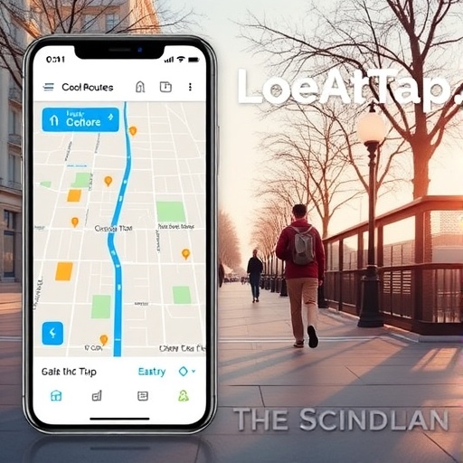
In the relentless Arizona sun, urban environments transform into veritable heat traps, forcing residents to contend with temperatures that can soar beyond the limits of human comfort and safety. Recognizing this escalating challenge, researchers at Arizona State University have engineered a groundbreaking digital navigation tool designed explicitly for hot climates—Cool Routes. This innovative web-based application breaks new ground by prioritizing pedestrian thermal comfort, charting paths that minimize exposure to intense heat by leveraging real-time meteorological data and urban morphological information.
Unlike conventional navigation aids that focus simply on distance or travel time, Cool Routes incorporates the concept of mean radiant temperature (MRT)—a comprehensive measure that accounts not only for air temperature but also the cumulative heat experienced from the sun’s radiation, reflected heat from surrounding surfaces, and thermal emissions from urban infrastructure. This metric provides an accurate representation of the actual thermal burden borne by individuals as they traverse outdoor environments, especially critical in heat-stressed locales like the metropolitan Phoenix area.
Phoenix’s climate starkly illustrates the necessity of this approach. When the sun beats down without obstruction, mean radiant temperatures can skyrocket to over 150 degrees Fahrenheit, presenting severe risks of heat-related illness. However, shaded areas can reduce this figure to below 100 degrees Fahrenheit, highlighting shade’s significant cooling effect. Cool Routes dynamically calculates these variations on an hourly basis using detailed urban data sets — including building footprints, tree canopy cover, and other structural elements — combined with up-to-the-minute weather forecasts.
Key to the validation of this system has been the use of MaRTy, a state-of-the-art rolling instrument station developed to quantify human thermal exposure. MaRTy captures critical environmental variables such as long-wave radiation, air temperature, and humidity along pedestrian pathways, offering a real-world benchmark against which Cool Routes’ predictive models can be compared. Field trials conducted during extreme heat events on the Arizona State University Tempe campus demonstrated remarkable agreement between Cool Routes’ heat load predictions and MaRTy’s direct measurements, underscoring the tool’s practical application in extreme conditions.
The underlying architecture of Cool Routes integrates sophisticated spatiotemporal data modeling techniques, enabling the system to simulate the thermal landscape of urban corridors with high spatial resolution. This capability allows the algorithm to compute alternative routes that reduce thermal stress by strategically routing pedestrians through shaded or otherwise cooler microenvironments. Intriguingly, these thermal-optimal routes often add only marginal distance—on the order of a quarter city block—thus preserving efficiency while enhancing safety and comfort.
The significance of Cool Routes extends beyond individual user benefits. Urban planners and policymakers stand to gain a powerful instrument for heat mitigation strategy development. By analyzing traffic patterns and thermal exposure data, municipal authorities can identify high-risk pedestrian zones and prioritize the installation of green infrastructure or shading elements accordingly. Moreover, the ability to simulate ‘what-if’ scenarios allows assessment of potential impacts from interventions such as increased urban canopy or reflective surfaces, facilitating data-driven investment decisions in urban heat adaptation.
The researchers further highlighted the scalability challenge inherent in expanding Cool Routes beyond the confines of a university campus. While the current computational model yields accurate outputs, processing the thermal profile for an entire city necessitates substantial computing resources. To surmount this barrier, the team aims to incorporate artificial intelligence algorithms capable of accelerating thermal exposure computations without compromising precision, thus bringing real-time routing at metropolitan scale closer to reality.
Efforts are underway to translate Cool Routes into a mobile application, enhancing accessibility and usability for a broader audience. This ongoing development, spearheaded by an undergraduate student at ASU, aims to refine the platform’s interface and performance to support wider adoption. The mobile app would facilitate pedestrian navigation during peak heat seasons, encouraging walking and public transit use while mitigating the health risks associated with urban heat exposure.
Fundamentally, Cool Routes embodies a paradigm shift in navigation technology, integrating environmental health considerations into travel planning. By harnessing climatic data, urban morphology, and predictive analytics, it empowers users to make informed decisions that optimize thermal comfort. Such innovations come at a critical juncture as global temperatures rise and urban heat islands intensify, exacerbating the public health impacts of heat waves.
Arizona State University’s SHaDE Lab has played a pivotal role in providing the foundational geospatial datasets essential for Cool Routes’ operation, including detailed representations of urban environments enriched with 2.5D models accounting for building heights and tree canopies. These datasets are crucial for accurately modeling solar exposure and shading patterns that drive spatial variation in mean radiant temperature.
In summary, Cool Routes represents a confluence of environmental science, data analytics, and user-centered design, offering a timely solution to the growing challenge of urban heat exposure. By enabling pedestrians to circumvent the most thermally hostile environments, it not only improves individual thermal comfort but also promotes healthier, more sustainable urban mobility practices. As climate change continues to exert pressure on urban infrastructures worldwide, such innovative tools will be indispensable components of adaptive city planning.
Subject of Research: Not applicable
Article Title: Cool routes: Real-time human thermal exposure routing
News Publication Date: 25-Jun-2026
Web References:
https://coolroutes.sensableheatscapes.com/
https://www.sciencedirect.com/science/article/pii/S0360132326004270#sec0020
References:
Buo, I., Hassan Khan, W., Middel, A., Crabtree, E., Emmott, F., Hariyani, D. (2026). Cool routes: Real-time human thermal exposure routing. Building and Environment. DOI: 10.1016/j.buildenv.2026.114622
Image Credits: Ariane Middel/Arizona State University
Keywords: Climate change adaptation, Human mobility, Navigation, Smartphones, Telemetry, Summer season, Climate change, Weather simulations, Weather forecasting, Urban planning
