

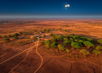
Satellites and Decision Trees Reveal How Climate Stress and Human Pressure Are Degrading a Nigerian Landscape
A 35-year satellite analysis of Wudil, Nigeria, links a 1.8 °C temperature rise, a 15 percent rainfall decline, and a ...
A 35-year satellite analysis of Wudil, Nigeria, links a 1.8 °C temperature rise, a 15 percent rainfall decline, and a ...

A systematic search of more than a thousand candidate vegetation indices found that a simple four-band formula outperforms NDVI for ...
Researchers in Spain show that the standard deviation of satellite-derived NDVI, especially during crop senescence, offers a low-cost way to ...
An eight-year satellite study of an Azerbaijani apple orchard shows NDVI can reliably predict yields only for individual plots of ...
New research finds that Kenya's satellite-based livestock insurance consistently failed to match herders' actual drought losses, and that this persistent ...
A remote field survey in the Iriri River Valley documents eighteen palm species and reveals how small streams, terrain shape, ...
A satellite-based study shows that earlier spring green-up amplifies vegetation vulnerability to rapidly intensifying flash droughts across most of the ...
An integrated satellite, GIS, and multi-criteria analysis has mapped groundwater potential across Bangladesh's largest inland wetland, revealing that only one ...
A Random Forest model built on satellite fire records shows that nearly 30 percent of forest in Nepal's mountainous Rasuwa ...
A new study of Coimbatore, India, combining Landsat satellite data with the InVEST Urban Cooling Model, finds summer land surface ...

Embark on a thrilling journey of discovery with Scienmag.com—your ultimate source for cutting-edge breakthroughs. Immerse yourself in a world where curiosity knows no limits and tomorrow’s possibilities become today’s reality!