

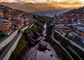
Fences Beat Full Maps: Why Urban Topography Decides Where Mudflows Go in Quito
A physics-based simulation of Quito's deadly 2022 La Gasca mudflow reveals that selectively reintroducing fences and buildings into elevation models ...
A physics-based simulation of Quito's deadly 2022 La Gasca mudflow reveals that selectively reintroducing fences and buildings into elevation models ...

Ecuadorian researchers found that dilute Ulva seaweed extracts significantly raised chlorophyll content in young cacao plantlets, though some treatments proved ...
The first comprehensive study of the Pacific desert mantis Musonia margheritae reveals striking female color polymorphism, sex-biased lifespans, and a ...
Scientists warn that a Super El Niño is destroying the algae that Galapagos marine iguanas eat just as trafficking networks ...
A diagnostic study of 843 secondary students across 21 Ecuadorian schools found that over 93 percent showed low or regular ...
A survey of 314 media workers in Ecuador, Peru, and Venezuela found that nearly one in five was at risk ...
A new Buoyancy Work Rate index couples atmospheric instability with vertical motion to explain why some El Niño years flood ...
Satellite radar, high-resolution terrain models, and field dating reveal that the northern boundary of Ecuador's Quito-Latacunga microblock is a 70-kilometer-wide ...
Structured deliberation workshops helped Ecuadorian cocoa farmer groups converge on shared sustainability visions, with measurable shifts in reasoning and consensus ...
Researchers in Ecuador found that using wind speeds from upper atmospheric levels of the ERA5 reanalysis, rather than conventional near-ground ...

Embark on a thrilling journey of discovery with Scienmag.com—your ultimate source for cutting-edge breakthroughs. Immerse yourself in a world where curiosity knows no limits and tomorrow’s possibilities become today’s reality!