A cutting-edge study harnesses the power of spaceborne Global Navigation Satellite System-Reflectometry (GNSS-R) technology to accurately measure sea ice thickness, a critical parameter for understanding climate change impacts in polar regions. This breakthrough method, using a sophisticated three-layer model, significantly enhances the precision of thickness estimation, offering a vital tool for climate scientists and polar explorers.

Credit: Satellite Navigation
A cutting-edge study harnesses the power of spaceborne Global Navigation Satellite System-Reflectometry (GNSS-R) technology to accurately measure sea ice thickness, a critical parameter for understanding climate change impacts in polar regions. This breakthrough method, using a sophisticated three-layer model, significantly enhances the precision of thickness estimation, offering a vital tool for climate scientists and polar explorers.
The polar regions are critical to understanding climate change due to their significant impact on global weather patterns and sea levels. Traditional methods of measuring sea ice thickness face challenges such as high costs and limited spatial coverage. Due to these challenges, an in-depth study is necessary to explore more efficient and accurate techniques for sea ice thickness retrieval.
Researchers at the School of Remote Sensing and Geomatics Engineering, Nanjing University of Information Science and Technology, have published their findings (DOI: 10.1186/s43020-024-00138-5) in the Satellite Navigation journal on 10 June 2024. The study introduces a refined method using Fengyun-3E (FY-3E) satellite data to estimate sea ice thickness (SIT) with a three-layer model, promising a significant advancement in polar climate studies.
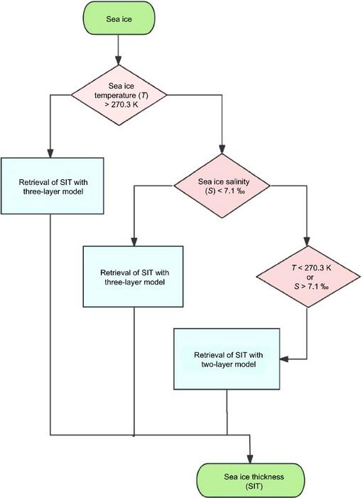
The study rigorously evaluates the performance of a novel three-layer model against the traditional two-layer model for retrieving SIT. Using sea ice data from 2022 and 2023, the three-layer model demonstrated a Root Mean Square Error (RMSE) of 0.149 meters and a correlation coefficient (r) of 0.830, indicating high accuracy. In contrast, the two-layer model, while effective for thin ice, showed reduced accuracy for thicker ice, with an RMSE of 0.162 meters and an r value of 0.789. To maximize accuracy, researchers combined the two models, resulting in an RMSE of 0.137 meters and an r value of 0.852. This combined approach significantly enhances the precision of SIT retrieval, making it applicable to ice thicknesses up to 1.1 meters. This marks a substantial advancement in remote sensing techniques for polar research.
Dr. Qingyun Yan, one of the lead researchers, stated, “This innovative approach leverages the strengths of both two-layer and three-layer models, providing a more accurate and reliable method for monitoring sea ice thickness. It represents a crucial step forward in our ability to study and understand polar regions.”
The enhanced accuracy of sea ice thickness measurements has profound implications for climate research, marine resource development, and polar expedition planning. This method offers a cost-effective and comprehensive solution for large-scale SIT monitoring, aiding in the prediction of climatic changes and supporting sustainable practices in polar regions. Future developments in GNSS-R technology may further refine these models, leading to even more precise measurements.
###
References
DOI
Original Source URL
Funding information
This research was funded by the National Natural Science Foundation of China under Grant 42001362.
About Satellite Navigation
Satellite Navigation (E-ISSN: 2662-1363; ISSN: 2662-9291) is the official journal of Aerospace Information Research Institute, Chinese Academy of Sciences. The journal aims to report innovative ideas, new results or progress on the theoretical techniques and applications of satellite navigation. The journal welcomes original articles, reviews and commentaries.
Journal
Satellite Navigation
Subject of Research
Not applicable
Article Title
Retrieval of sea ice thickness using FY-3E/GNOS-II data
Article Publication Date
10-Jun-2024
COI Statement
The authors declare that they have no competing interests.


