As Florida braces for what meteorologists predict to be a particularly active 2025 Atlantic hurricane season, the state confronts a critical challenge: water, rather than wind, is poised to be the deadliest force. Analysis from the National Hurricane Center underscores the grave reality that 86% of fatalities related to hurricanes and tropical storms in the United States over the last decade stem from water-related hazards, including freshwater flooding, storm surge, and rip currents. Remarkably, over half of these deaths are attributed to drownings caused by inland flooding, emphasizing the paramount importance of precise rainfall and flood prediction systems. This hydrometeorological threat necessitates innovative observational networks capable of delivering real-time environmental data with unprecedented accuracy.
Emerging as a pivotal player in this arena is Florida Atlantic University’s Sensing Institute, known as I-SENSE, which spearheads the Southeast Atlantic (SEA) Econet. This sophisticated mesh of atmospheric and hydrological monitoring stations forms an academic-led infrastructure pivotal to the enhancement of weather forecasting and disaster preparedness. Strategically distributed from Key West, Florida, stretching northward to Waities Island in South Carolina, the SEA Econet serves as an integrative platform for collecting and disseminating meteorological and hydrological data, effectively bridging the gap between academic research and operational weather services.
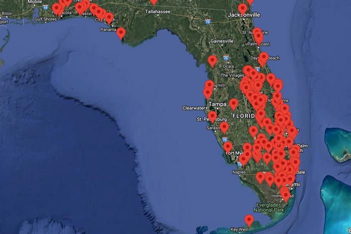
At the heart of Florida’s contribution to this regional network, FAU manages a substantial subnetwork comprised of over 160 atmospheric and 30 hydrological stations spanning 32 counties. This makes the FAU-operated mesonet the most extensive academic weather station network in the Southeastern United States, and the fourth largest in the entire country. The stations systematically record high-resolution data including but not limited to temperature, humidity, atmospheric pressure, wind velocity, precipitation, and water levels in rivers and coastal zones. The deployment emphasizes spatial granularity and temporal frequency, enabling hyper-localized data gathering that feeds directly into forecasting models.
Beyond its Floridian base, the SEA Econet extends its reach with additional stations positioned in states including Oklahoma, Texas, Illinois, and Georgia. South Carolina, a key partner in this enterprise, supports a comprehensive array of observational assets consisting of weather-only stations, combination weather and water level stations, and water level-only stations. Significantly, the Econet also aggregates data from an additional 65 independent stations throughout South Carolina, augmenting the network’s regional saturation and resilience. This expansive observational footprint is critical for capturing the complex mesoscale phenomena that typify tropical storm systems in the Southeast.
FAU’s I-SENSE executive director, Dr. Jason Hallstrom, emphasizes that the foundation of timely and effective emergency response systems lies in accurate, real-time environmental data. According to Dr. Hallstrom, the statewide infrastructure meticulously constructed by I-SENSE empowers forecasters and emergency planners by supplying continuous streams of validated data during severe weather episodes. This digital backbone ensures that protective actions such as sheltering and evacuation are grounded in robust situational awareness, fostering the safety of millions of Floridians.
A distinguishing characteristic of FAU’s network infrastructure lies in its cost efficiency and self-reliance. Unlike many counterparts in the National Mesonet Program relying heavily on state appropriations, FAU’s system was envisioned and built without direct state funding. Over the past decade and a half, the university has leveraged more than $8 million in federal research grants—sourced from the National Science Foundation, NOAA, and EPA—to engineer innovative telemetry platforms, sensor arrays, and data assimilation frameworks. The open architecture design prioritizes scalability and affordability, allowing expanded coverage without proportionate increases in operational expenditures.
This frugal yet robust platform yields transformative benefits for a diverse array of stakeholders. Data harvested by the FAU-controlled network seamlessly integrates into National Weather Service forecasting products, bolsters water management strategies employed by entities like the South Florida Water Management District, and supports conservation efforts spearheaded by the National Park Service. Counties across Florida—ranging from urban hubs such as Miami-Dade and Broward to more rural locales like Saint Lucie and Monroe—derive critical, localized insights enabling adaptive response to flooding, storm surge, and wind threats at the community level.
The extensive collaboration underlying FAU’s mesonet reflects the broad multi-sector value of the network. Partnerships span governmental agencies such as the Florida Fish and Wildlife Conservation Commission and the Naval Sea Systems Command, commercial stakeholders including U.S. Sugar and SBA Communications, and specialized research organizations like the Southeast Coastal Ocean Observing Regional Association. This coalition fosters cross-disciplinary innovation and data sharing, ensuring that the network remains robust and responsive to evolving scientific and operational demands.
Looking forward, I-SENSE is ambitiously charting a path to nearly triple the density of the existing observation network within five years. The expansion effort seeks to deploy approximately 445 stations, focusing on underserved and high-risk zones in Central and North Florida. This densification plan aims to alleviate notable spatial gaps in forecast data, especially in regions vulnerable to flash flooding and slow-moving storm systems. Concurrently, the establishment of a dedicated operations team will enhance system maintenance, data quality control, and user engagement through novel communication platforms tailored to emergency responders and public agencies.
The imperative for this infrastructure comes amid mounting threats posed by increasingly frequent and intense tropical cyclones interacting with the state’s highly developed coastal and inland environments. Florida’s economic sectors—including tourism, real estate, healthcare, and agriculture—are deeply susceptible to weather disruptions. Since 1980, the state has experienced weather-related damages exceeding $400 billion, underscoring its vulnerability. Recent hurricanes, such as Helene and Milton, with a combined devastating toll exceeding $100 billion and nearly 240 confirmed fatalities, spotlight the urgent necessity for enhanced predictive capabilities.
Dr. Stella Batalama, dean of FAU’s College of Engineering and Computer Science, articulates the broader vision underpinning the university’s research and operational commitment to weather resilience. She highlights how the I-SENSE mesonet synergizes cutting-edge sensor technologies, machine learning algorithms, and wireless communication protocols to generate real-time, actionable insights. The expansion and continued enhancement of this network are envisioned to position Florida not only at the forefront of national weather preparedness but also as a global leader in environmental monitoring technologies.
Florida Atlantic University’s Sensing Institute epitomizes a multidisciplinary approach to integrating atmospheric science, hydrology, electrical engineering, and computer science. By embedding sophisticated sensing platforms within an agile data ecosystem, the institute enables improved forecasting precision, timely emergency alerts, and informed decision-making that collectively reduce risk to life and property. This model exemplifies how academic innovation, strategic partnerships, and targeted federal support can coalesce to confront the pressing challenges wrought by climate change and increasingly volatile weather patterns.
The SEA Econet’s durability and success provide a template for future mesonet initiatives aiming to balance fiscal constraints with the imperatives of comprehensive environmental monitoring. The strategic emphasis on open-source architecture, coupled with partnerships across sectors, ensures a versatile and scalable infrastructure responsive to emergent scientific questions and operational requirements. As the network grows, continued interdisciplinary collaboration and investment in emergent technologies such as AI-driven predictive analytics and sensor miniaturization will be essential to sustaining and amplifying its societal impact.
Ultimately, Florida Atlantic University’s I-SENSE Institute demonstrates that resilient, data-driven infrastructure forms the backbone of modern meteorological forecasting and disaster mitigation strategies. By delivering high-fidelity, hyper-local environmental data across a vast and climatically complex region, the SEA Econet substantially enhances the capacity of agencies and communities to anticipate, prepare for, and respond to severe weather hazards. This paradigm of innovation and partnership offers a beacon for regions worldwide confronting the intensifying risks of extreme hydrometeorological events.
Subject of Research: Advanced meteorological and hydrological sensing networks for hurricane and flood forecasting
Article Title: FAU’s I-SENSE Leads Expansion of Southeast Atlantic Weather and Water Monitoring Network to Enhance Hurricane Forecasting and Public Safety
News Publication Date: Not specified
Web References:
- Florida Atlantic University: https://www.fau.edu/
- I-SENSE Institute: http://www.isense.fau.edu
- FAU College of Engineering and Computer Science: https://eng.fau.edu
Image Credits: FAU I-SENSE
Keywords: Remote sensing; Applied sciences and engineering; Hydrology; Climatology; Technology; Sensors; Atmosphere; Weather; Weather forecasting; Hydrosphere; Tropical climates; Natural disasters; Floods
