In a groundbreaking study published in Environmental Earth Sciences, researchers have unveiled a comprehensive evaluation of groundwater quality in the Tonk District of Rajasthan, India, employing an innovative multi-parametric indexing technique coupled with advanced geospatial analysis. This integrative approach not only sheds light on the current status of water suitability for both drinking and irrigation but also sets a new standard for assessing groundwater resources in semi-arid regions vulnerable to water stress.
Groundwater remains the backbone of water security in many parts of India, especially in arid and semi-arid zones such as Rajasthan. However, escalating demands from agriculture and domestic use have significantly pressured these aquifers, leading to quality degradation that often goes unnoticed until it presents severe health and agricultural challenges. The recent work undertaken by V. Deep, R. Jain, A. Singh, and their team addresses this critical gap by systematically evaluating groundwater quality through a robust multi-parametric indexing system.
The methodology integrates physicochemical parameters such as pH, electrical conductivity, total dissolved solids, major cations (calcium, magnesium, sodium, potassium), and anions (chloride, sulfate, bicarbonate, nitrate), alongside microbiological assessments where applicable. These parameters are then collectively analyzed within a multi-criteria decision-making framework that translates raw data into a comprehensive water quality index (WQI). This index serves as a quantifiable and easily interpretable indicator for policymakers, farmers, and public health officials.
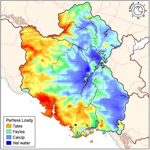
A salient feature of the study lies in the geospatial mapping techniques employed. Using Geographic Information Systems (GIS) combined with remote sensing data, the research team spatially depicted areas within Tonk District where groundwater quality is compromised. This spatial information is pivotal because it reveals localized contamination hotspots, groundwater salinity patterns, and zones vulnerable to anthropogenic influences such as agricultural runoff and industrial effluents.
The findings indicate a spatial heterogeneity in groundwater quality across Tonk District. While certain pockets exhibited groundwater well within safe limits for drinking and irrigation, other regions portrayed alarming levels of parameters such as electrical conductivity and nitrate concentrations, signaling potential health hazards and risks to crop productivity. This spatial variability underscores the necessity for region-specific interventions rather than blanket policies for groundwater management.
One of the study’s remarkable insights pertains to the pilot application of the Water Quality Index (WQI) for irrigation suitability. Water quality directly influences soil health and crop yield, especially under arid climatic conditions where evapotranspiration rates are high. Parameters such as sodium adsorption ratio (SAR), permeability index, and residual sodium carbonate, traditionally used in agronomy, were integrated within the multi-parametric framework to present a holistic irrigation water assessment.
Additionally, the research underscores the latent risks posed by rising nitrate levels detected in several sampling locations. Elevated nitrates in drinking water are linked to methemoglobinemia or “blue baby syndrome” and have been implicated in several chronic health conditions. The geospatial delineation of nitrate contamination hotspots paves the way for targeted groundwater recharge and remediation programs.
Through an interdisciplinary approach that bridges hydrochemistry, geospatial analytics, and environmental science, the study propels sustainable water resource management to new heights. Importantly, the researchers advocate for the routine use of multi-parametric and geospatial assessments at district and sub-district scales, suggesting that such data-driven initiatives could inform smarter irrigation scheduling, groundwater withdrawal regulations, and pollution control measures.
The Tonk District’s unique geological and climatic conditions, marked by hard rock aquifers and erratic monsoon patterns, introduce complex dynamics to groundwater recharge and quality maintenance. This study carefully accounts for these local factors, emphasizing that groundwater monitoring cannot be a one-size-fits-all endeavor. Instead, in regions where water scarcity and quality issues converge, adaptive management supported by scientific insights remains the only way forward.
In practical terms, the study’s multi-parametric index facilitates a tiered classification of water quality into categories such as excellent, good, permissible, doubtful, and unsuitable for human or agricultural use. Policymakers and groundwater managers are thus provided with a nuanced tool to prioritize resource allocation, emergency interventions, and long-term remediation strategies, particularly crucial in areas where groundwater is the lifeline of livelihoods.
Furthermore, the research highlights the importance of engaging local stakeholders in groundwater quality assessments. Community awareness programs based on these scientific findings can foster responsible water use, prevent contamination at the source, and encourage participatory groundwater governance. The effective dissemination of the geospatial analysis results through user-friendly maps and apps could revolutionize how rural communities perceive and protect their water resources.
While the study sets a new benchmark in groundwater quality assessment, it also acknowledges the need for continuous monitoring to capture temporal variations induced by seasonal rainfall, groundwater pumping, and land-use changes. Future research could expand on integrating real-time data sensors and predictive modeling to anticipate groundwater quality trends, empowering preemptive management actions.
The implications of such research transcend regional boundaries; as many regions worldwide grapple with water scarcity and pollution, the techniques and findings from this study provide a replicable model. Employing multi-parametric indexes calibrated to local contexts and integrated with advanced geospatial technology offers a pragmatic path toward safeguarding an increasingly precious resource—groundwater.
Importantly, this research exemplifies how multidisciplinary collaboration among hydrologists, geologists, environmental scientists, and data analysts can merge traditional field methods with cutting-edge technology. The resultant synergy accelerates the translation of scientific knowledge into actionable water management strategies offering tangible benefits to public health, agriculture, and environmental sustainability.
In summary, the evaluation of groundwater in Tonk District utilizing multi-parametric indexing and geospatial methodologies is a testament to innovative research addressing a pressing global challenge. By providing precise, spatially detailed quality assessments, this study equips stakeholders with vital tools to protect and sustainably utilize groundwater—a cornerstone of life and development in arid environments.
As water scarcity intensifies globally under the twin pressures of climate change and population growth, such pioneering assessments and indexing systems will be instrumental in crafting resilient water governance frameworks. The Tonk District study thus marks a critical step in harnessing science and technology to secure the future of groundwater resources—not only in Rajasthan but across the arid landscapes of the world.
Article References:
Deep, V., Jain, R., Singh, A. et al. Evaluation of groundwater for drinking and irrigation purposes using Multi-parametric indexing and Geospatial approach: Tonk District, Rajasthan, India. Environ Earth Sci 84, 641 (2025). https://doi.org/10.1007/s12665-025-12607-4
