A groundbreaking study emerging from North Carolina State University and the University of North Carolina at Chapel Hill has reshaped our understanding of coastal flooding frequency. For decades, tide gauge data collected from marine water levels have served as the primary metric for estimating how often flooding occurs in coastal communities. However, this new research exposes significant limitations in this approach, revealing that actual flooding events transpire far more frequently than tide gauges indicate. By deploying innovative land-based sensing technology, researchers have documented a markedly higher number of flood occurrences, challenging longstanding assumptions and urging a reconsideration of flood monitoring methodologies.
Traditional assessments rely heavily on tide gauge measurements, which record water levels in coastal waters and inform two widely accepted flooding thresholds: the National Oceanic and Atmospheric Administration (NOAA) High Tide Flooding (HTF) threshold and the National Weather Service’s (NWS) minor flood threshold. These thresholds have dictated our comprehension of flood frequency and duration, guiding public policy and infrastructure planning. Yet this reliance on marine-level data fails to capture the complex, localized dynamics of flooding on the land itself, especially as sea-level rise accelerates and brings unprecedented challenges to coastal regions.
The study’s authors, including Miyuki Hino and Katherine Anarde, bring a multidisciplinary approach to this issue, merging city and regional planning with coastal engineering. They emphasize that tide gauges effectively measure water levels in open water but do not adequately reflect the sustained presence of water permeating land surfaces, which directly affects communities. Floodwaters that inundate streets and neighborhoods can persist for extended periods, but these durations often remain invisible to gauge-based thresholds. This discrepancy necessitates a radical shift towards land-focused flood monitoring systems.
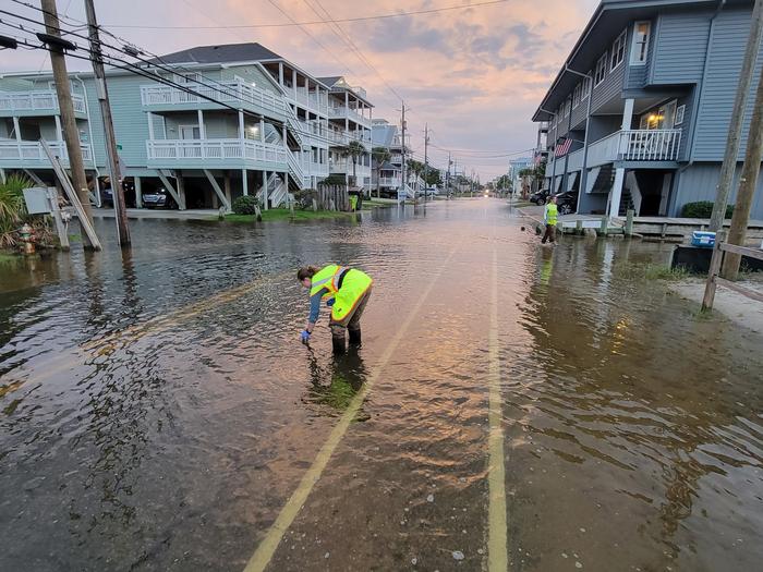
To address these methodological gaps, the research team developed and deployed a network of specialized land-based sensors across three vulnerable North Carolina coastal communities: Beaufort, Carolina Beach, and Sea Level. Unlike tide gauges positioned offshore, these sensors were strategically situated on roadways to detect actual flooding impacting daily life and infrastructure. Over the course of one year, the sensors recorded flood events with remarkable fidelity, documenting the real-world impact on communities and revealing a level of flooding previously unreported.
The contrasting results between tide gauge data and sensor readings were striking. In Sea Level, for instance, the sensors detected flooding on 128 days during the study period, a figure that dramatically surpassed the 31 days indicated by the NWS minor flood threshold and the mere 9 days recognized by the NOAA HTF standard. When excluding extreme storm events like hurricanes, these discrepancies remained profound. Such findings underscore the limitations of current monitoring frameworks that underestimate flood frequency, potentially leaving communities unprepared for the growing reality of recurrent flooding.
Furthermore, the study elucidates how tide gauge-based thresholds sometimes overestimate flooding, exemplified by Carolina Beach, where sensor data showed 65 flood days, but NWS thresholds suggested 120 days. This overestimation points to the complexity of accurately correlating water levels offshore with terrestrial flooding occurrences. It sheds light on the nuanced spatial variability of flooding influenced by local topography, drainage infrastructure, and land use, which cannot be adequately resolved through marine measurements alone.
Beyond frequency, the duration of flooding is a critical dimension overlooked by traditional tide gauge analysis. Researchers observed that water levels on the land take longer to recede, prolonging flood impact on residents and infrastructure. Marine tide measurements often miss this delayed drainage process, leading to underreported flood durations. Accurately capturing how long inundation lasts is vital for emergency response, urban planning, and designing resilient infrastructure that can withstand persistent water exposure.
The implications of these findings are profound for policy, urban design, and climate adaptation strategies. Coastal communities around the world are confronting the dual pressures of sea-level rise and more frequent, chronic flooding events. Reliance on outdated measurement approaches risks misinforming preparedness and mitigation efforts, potentially exacerbating vulnerabilities. Incorporating land-based sensor data promises a more accurate picture of flood risk, enabling targeted investment in flood defenses, infrastructure retrofitting, and community resilience.
The study’s authors are actively collaborating with local governments and community organizations to translate these technological and scientific advancements into actionable strategies. Recognizing that each coastal community faces unique geographic and social circumstances, the team advocates for customized interventions informed by precise, locally gathered data. This approach departs from one-size-fits-all solutions, emphasizing tailored responses that address specific challenges and priorities of affected populations.
Technical innovation in flood monitoring extends beyond sensor deployment. Researchers integrate sensor data with hydrodynamic modeling, geographic information systems (GIS), and real-time analytics to map flood pathways, predict future flooding scenarios, and evaluate mitigation measures. This fusion of observational and computational techniques represents a frontier in environmental engineering, catalyzing smarter, data-driven responses to climate-induced challenges.
This research is published in the open-access journal Communications Earth & Environment, ensuring that its insights are widely accessible to scientists, policymakers, and the public. By leveraging state-of-the-art land-based sensing technology, the study pioneers a new paradigm in coastal flood detection, emphasizing the importance of ground truth data that reflects the lived experience of residents rather than purely marine observations. Its findings serve as a clarion call for reevaluating flood monitoring standards in an era of accelerating sea-level rise.
The funding sources for this work span federal agencies, environmental programs, and academic institutions, reflecting broad recognition of its significance. Support from the U.S. Department of Homeland Security, NOAA, NASA, the National Science Foundation, and regional stakeholder partnerships underscores the interdisciplinary and applied nature of the research. Together, these efforts aspire to safeguard coastal communities through enhanced understanding and management of flood risks.
As climate models project continued sea-level rise and increased frequency of high-tide flooding, the urgency of refining our measurement tools cannot be overstated. This study’s demonstration of chronic flooding outside of extreme weather events shifts the narrative around coastal risk, highlighting everyday flood hazards that degrade quality of life and impose economic burdens. The integration of land-based sensors presents a pivotal advancement in monitoring, equipping communities with the knowledge needed to build resilience in the face of rising waters.
In conclusion, this pioneering research challenges entrenched methodologies in coastal flood assessment, underscoring the necessity of land-based measurements alongside traditional marine data. It paints a more comprehensive portrait of flooding events, revealing heightened frequency and duration that bear direct consequences for vulnerable populations. The study’s innovative approach fosters a deeper understanding of coastal flooding dynamics, setting the stage for improved adaptation strategies and more resilient coastal futures.
Subject of Research: Not applicable
Article Title: Land-based Sensors Reveal High Frequency of Coastal Flooding
News Publication Date: 2-Jun-2025
Image Credits: Sunny Day Flooding Project
Keywords: coastal flooding, land-based sensors, tide gauge data, sea-level rise, flood frequency, flood duration, flooding monitoring, coastal resilience, environmental engineering, climate adaptation, urban planning, flood mitigation
