


For centuries before European colonization, communities in Colombia’s Caribbean lowlands engineered a vast water-management system that transformed seasonal flooding into an agricultural advantage. New archaeological research suggests that the extraordinary network was not imposed by kings, states, or centralized rulers, but built through cooperation among local family groups. The finding challenges long-standing assumptions about how complex societies organize large-scale infrastructure—and offers an unexpected lesson for Colombia’s modern water crisis.
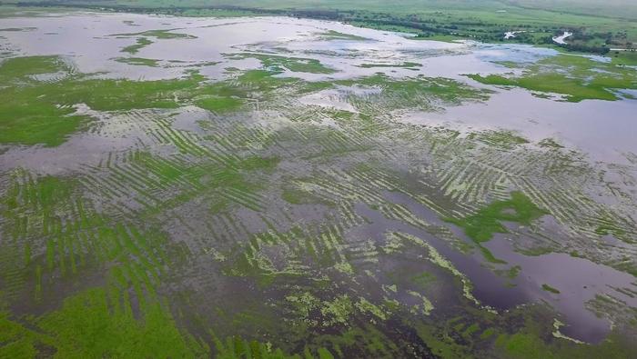
The ancient field systems of La Mojana extend across approximately 500,000 hectares, an area comparable to the Grand Canyon National Park and roughly three times the size of London. Built and maintained from the first centuries BC until about the 11th century AD, the systems consisted of raised planting platforms separated by canals. From high altitude, the geometric traces remain visible across the landscape, revealing an infrastructure designed to work with the region’s natural hydrology rather than resist it.
During the wet season, the canals absorbed and redirected excess water, reducing the impact of floods. In drier months, they gradually redistributed stored water across the surrounding landscape. The elevated fields provided better-drained, more fertile ground for crops, while the canals may also have created opportunities for trapping fish. Together, the ridges and waterways formed a dynamic system capable of buffering communities against both extremes of the tropical climate.
Archaeologists have traditionally assumed that projects of such scale required powerful rulers to command labor and coordinate construction. Elaborate gold objects and ceramics found in the wider region have also encouraged the view that La Mojana’s societies were hierarchical chiefdoms moving toward state formation. But a study led by researchers at the University of Cambridge presents a different interpretation: the hydraulic landscape may have been created by relatively horizontal communities that coordinated their labor locally, without evidence of a centralized government.
Using satellite imagery, the team mapped a 500-hectare section of pre-Hispanic fields near San Marcos in the department of Sucre. The researchers identified and measured 1,600 ridges and 63 housing platforms, reconstructing the original dimensions of the earthworks. At the time of construction, the ridges stood approximately 1.4 meters above the lowest points of the canals. These measurements allowed the team to estimate how much soil had been moved and how many people would have been needed to complete the work.
The researchers developed a labor model that incorporated ridge volume, local geology, population density, available technology, and likely working practices. The heavy clay soils of the Colombian Caribbean would have made excavation difficult, especially because metal shovels were not available in the region. Workers may have relied on wooden tools, although direct evidence for the exact implements remains limited. Even under these demanding conditions, the calculations indicate that a single canal-and-ridge complex could have been built in less than two months—approximately half of a dry season.
That estimate dramatically reduces the labor investment previously imagined for the construction of the fields. Starting with an estimated population of 1,600 people in the study area, the researchers modeled a workforce of about 800. They describe this as a conservative figure because subsistence farming in Indigenous societies commonly involved men, women, and possibly children. Under such conditions, construction could have been organized through temporary collective action among households rather than through coercive authority or a permanent administrative class.
The result is more than a revision of ancient history. It speaks directly to the present-day environmental crisis in La Mojana, where communities face increasingly destructive floods and severe droughts linked to climate change, intensive agriculture, and failed water policy. Modern interventions have often attempted to block or confine water with dykes, adapting the floodplain to agricultural and livestock models developed for non-flooding environments. Yet the Caregato dyke has suffered repeated breaches since 2021, causing damage to homes, farmland, and ecosystems.
The ancient system suggests an alternative approach: instead of trying to stop water, communities could manage its movement across the floodplain using locally adapted infrastructure. The researchers emphasize that state support and resources may still be essential, but direct top-down intervention is not necessarily required. Their findings indicate that local populations could lead restoration and adaptation efforts based on ancestral principles. The team has also released its analytical code as open source, allowing researchers to test the labor and organization model in other regions. The study, published in Communications Sustainability, presents La Mojana’s ancient fields as both an archaeological achievement and a powerful reminder that cooperation—not centralized control—can produce infrastructure on a monumental scale.
News Publication Date: 11-Aug-2026
Web References: https://www.nature.com/articles/s44458-026-00128-5; https://www.eurekalert.org/multimedia/1145454; https://reverseaction.org/
References: J. Vieri, F. Montejo Gaitán, M. Carrero-Pazos, M. Martinón-Torres, “Collective labour and sustainability of pre-Hispanic field systems in La Mojana,” Communications Sustainability (2026). DOI: 10.1038/s44458-026-00128-5
Cite Scienmag News
Courtney Benton. (August 11, 2026). Pre-Hispanic farmers built vast bottom-up water system without bosses, archaeologists find. Scienmag. https://scienmag.com/pre-hispanic-farmers-built-vast-bottom-up-water-system-without-bosses-archaeologists-find/
Courtney Benton. "Pre-Hispanic farmers built vast bottom-up water system without bosses, archaeologists find." Scienmag, 11 August 2026, https://scienmag.com/pre-hispanic-farmers-built-vast-bottom-up-water-system-without-bosses-archaeologists-find/. Accessed 3 September 2026.
Courtney Benton. "Pre-Hispanic farmers built vast bottom-up water system without bosses, archaeologists find." Scienmag. August 11, 2026. https://scienmag.com/pre-hispanic-farmers-built-vast-bottom-up-water-system-without-bosses-archaeologists-find/


