Synthetic aperture radar (SAR) is a type of remote sensing from satellites that uses the reflection of radio waves to relay information about the surface of the earth. This reflection, or backscatter, is responsive to physical properties, such as roughness, vertical structure, and moisture. SAR is widely used for different types of mapping and monitoring, but signal interference in urban environments can cause distortions that make SAR data difficult to interpret.

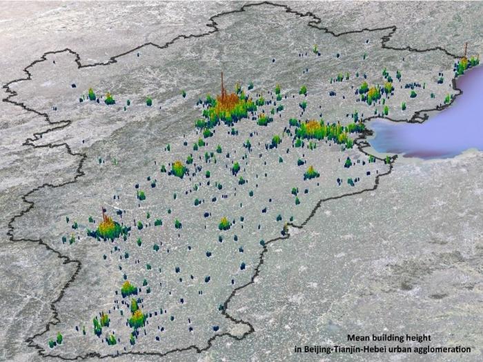
Credit: Xuecao Li, China Agricultural University
Synthetic aperture radar (SAR) is a type of remote sensing from satellites that uses the reflection of radio waves to relay information about the surface of the earth. This reflection, or backscatter, is responsive to physical properties, such as roughness, vertical structure, and moisture. SAR is widely used for different types of mapping and monitoring, but signal interference in urban environments can cause distortions that make SAR data difficult to interpret.
By combining optical signals with historical SAR backscatter coefficient data, SAR data can be refined and used to monitor changes to an urban environment over time. This reconstruction technique was described in a paper published in Journal of Remote Sensing on 23 July.
“We set out to fill the knowledge gaps in the reconstruction of long-term backscatter coefficient data. This study developed a method that would reconstruct the data over the past three decades (1990 through 2022) based on Sentinel-1 Ground Range Detected data and long-term Landsat data in the Jing-Jin-Ji region. This could significantly support three-dimensional dynamics in urban domains,” said Xuecao Li, a professor at the College of Land Science and Technology at the China Agricultural University in Beijing, China.
Researchers chose the Jing-Jin-Ji region of China, which includes Beijing and Tianjin and 11 major cities, to test their reconstruction technique because this part of China has changed drastically over the past 40 years due to rapid urbanization. They developed a building height model based on reference building heights in seven cities. To understand the relationship between the backscatter coefficient of Sentinel-1 and optical Landsat images, researchers used a regression model and then expanded it to cover the entire region.
The trained model was able to successfully map the optical data over the long-time backscatter coefficient. The success of this technique was clear when it was used to estimate changing building height. When the historical backscatter coefficient data was used to estimate building heights, the data was able to accurately capture nuances in the changing urban landscape of Beijing. It was able to accurately depict areas of rapid construction in the urban core of Beijing and in the Haidian and Chaoyang neighborhoods where average building height increased between 1990 and 2000. It also accurately mapped the increased building height in the outer areas of Beijing in the following decades.
“Overall, our results suggest that the estimated backscatter coefficient has a promising potential for exploring urban expansion in the vertical dimension,” said Li. “In addition to estimating building height, the long-term and high-resolution backscatter coefficient also has promising potential for urban studies regarding impervious surface classification, change detection, and flood extent mapping. The proposed approach in this study allows researchers to estimate the backscatter with finer resolutions for decades regarding seasonal or monthly changes.”
Looking ahead, researchers hope to apply what they learned through this study on a global scale. “The estimated building height in the Jing-Jin-Ji region can be further used for investigating the urban environmental issues regarding the 3D perspective, such as the urban heat island, dynamic building height, and carbon emissions, which are expected to provide useful information for achieving sustainable development goals,” said Li.
Other contributors include Bo Yuan at Tarim University; Guojiang Yu at China Agricultural University; Linze Li at China Three Gorges Corporation; Donglie Liu at the Natural Resources Satellite Remote Sensing Application Center; Jincheng Guo at the Guizhou First Surveying and Mapping Institute; and Yangchun Li at the Guizhou Geological Environment Monitoring Institute.
The National Natural Science Foundation of China, the National Natural Science Foundation of China/RGC Joint Research Scheme, the NSFC Excellent Young Scientists Fund, and the Chinese University Scientific Fund supported this research.
Journal
Journal of Remote Sensing
Method of Research
Imaging analysis
Subject of Research
Not applicable
Article Title
Reconstructing Long-Term Synthetic Aperture Radar Backscatter in Urban Domains Using Landsat Time Series Data: A Case Study of Jing–Jin–Ji Region
Article Publication Date
23-Jul-2024
COI Statement
The authors declare that they have no competing interests