Researchers at USC have developed a new method to accurately predict wildfire spread. By combining satellite imagery and artificial intelligence, their model offers a potential breakthrough in wildfire management and emergency response.

Credit: USC
Researchers at USC have developed a new method to accurately predict wildfire spread. By combining satellite imagery and artificial intelligence, their model offers a potential breakthrough in wildfire management and emergency response.
Detailed in an early study proof published in Artificial Intelligence for the Earth Systems, the USC model uses satellite data to track a wildfire’s progression in real time, then feeds this information into a sophisticated computer algorithm that can accurately forecast the fire’s likely path, intensity and growth rate.
The study comes as California and much of the western United States continues to grapple with an increasingly severe wildfire season. Multiple blazes, fueled by a dangerous combination of wind, drought and extreme heat, are raging across the state. Among them, the Lake Fire, the largest wildfire in the state this year, has already scorched over 38,000 acres in Santa Barbara County.
“This model represents an important step forward in our ability to combat wildfires,” said Bryan Shaddy, a doctoral student in the Department of Aerospace and Mechanical Engineering at the USC Viterbi School of Engineering and the study’s corresponding author. “By offering more precise and timely data, our tool strengthens the efforts of firefighters and evacuation teams battling wildfires on the front lines.”
Reverse-engineering wildfire behavior with AI
The researchers began by gathering historical wildfire data from high-resolution satellite images. By carefully studying the behavior of past wildfires, the researchers were able to track how each fire started, spread and was eventually contained. Their comprehensive analysis revealed patterns influenced by different factors like weather, fuel (for example, trees, brush, etc.) and terrain.
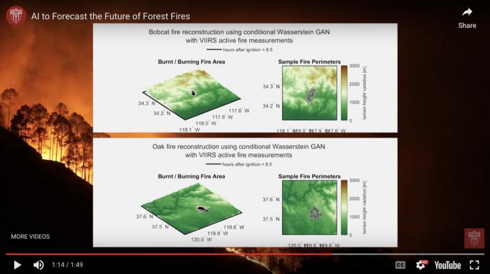
They then trained a generative AI-powered computer model known as a conditional Wasserstein Generative Adversarial Network, or cWGAN, to simulate how these factors influence how wildfires evolve over time. They taught the model to recognize patterns in the satellite images that match up with how wildfires spread in their model.
They then tested the cWGAN model on real wildfires that occurred in California between 2020 and 2022 to see how well it predicted where the fire would spread.
“By studying how past fires behaved, we can create a model that anticipates how future fires might spread,” said Assad Oberai, Hughes Professor and Professor of Aerospace and Mechanical Engineering at USC Viterbi and co-author of the study.
Using AI to predict wildfires: Impressive model
Oberai and Shaddy were impressed that the cWGAN, initially trained on simple simulated data under ideal conditions like flat terrain and unidirectional wind, performed well in its tests on real California wildfires. They attribute this success to the fact that the cWGAN was used in conjunction with actual wildfire data from satellite imagery, rather than on its own.
Oberai, whose research focuses on developing computer models to understand the underlying physics of various phenomena, has modeled everything from turbulent airflow over aircraft wings to infectious disease and how cells multiply within tumors and interact with their surroundings. Of everything he has modeled, Oberai notes that wildfires are among the most challenging.
“Wildfires involve intricate processes: Fuel like grass, shrubs or trees ignites, leading to complex chemical reactions that generate heat and wind currents. Factors such as topography and weather also influence fire behavior — fires don’t spread much in moist conditions but can move rapidly in dry conditions,” he said. “These are highly complex, chaotic and nonlinear processes. To model them accurately, you need to account for all these different factors. You need advanced computing.”
Watch on YouTube:
About the study: Additional co-authors include undergraduate student Valentina Calaza of the Department of Aerospace and Mechanical Engineering at USC Viterbi; Deep Ray of the University of Maryland, College Park (formerly a postdoctoral student at USC Viterbi); Angel Farguell and Adam Kochanski of San Jose State University; Jan Mandel of the University of Colorado, Denver; James Haley and Kyle Hilburn of Colorado State University, Fort Collins; and Derek Mallia of the University of Utah.
The research was funded by the Army Research Office, NASA and the Viterbi CURVE program.
Journal
Artificial Intelligence for the Earth Systems
Method of Research
Computational simulation/modeling
Subject of Research
Not applicable
Article Title
Generative Algorithms for Fusion of Physics-Based Wildfire Spread Models with Satellite Data for Initializing Wildfire Forecasts
Article Publication Date
23-Apr-2024


