

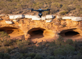
Drone LiDAR Finds Three Unregistered Aboriginal Rock Shelters
A drone-mounted LiDAR survey identified three previously unregistered Aboriginal rock shelters containing rock art and stone artefacts in Australia’s Blue ...
A drone-mounted LiDAR survey identified three previously unregistered Aboriginal rock shelters containing rock art and stone artefacts in Australia’s Blue ...

A 2026 Perspective proposes a volumetric monitoring framework to detect underground urban expansion, connect it to environmental and infrastructure evidence, ...
KAIST’s GeoCore-9B outperformed task-specific systems on key public-dataset measures for cloud removal and led some radar-to-optical conversion metrics.
A 23-year satellite analysis of northern peatlands reveals widespread local greening but no significant map-scale increase in leaf area, with ...
Gross primary productivity, or GPP, is the amount of carbon captured by plants through photosynthesis before subtracting the carbon used ...
A study published on 19 March 2025 examined Ayu fish nursery conditions in three Vietnamese estuaries using field sampling, satellite ...
A study of 533 Italian schoolchildren combining satellite imagery with psychometric scales found that children in highly natural residential areas ...
Researchers at the University of Dhaka used Sentinel-1 radar coherence change detection to map damage from five major cyclones in ...
A new global monthly groundwater dataset at 1 km resolution for 2002-2020 combines GRACE satellite gravity, environmental predictors and machine ...
A new one-metre resolution land-cover dataset quantifies floral resources for pollinators across twelve Central New York counties, combining federal and ...

Embark on a thrilling journey of discovery with Scienmag.com—your ultimate source for cutting-edge breakthroughs. Immerse yourself in a world where curiosity knows no limits and tomorrow’s possibilities become today’s reality!