Machine Learning Maps Landslide Risk in Bangladesh
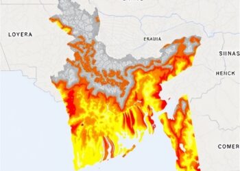
In a groundbreaking study, researchers have harnessed advanced remote sensing and Geographic Information Systems (GIS) technologies to map landslide susceptibility ...
In a groundbreaking study, researchers have harnessed advanced remote sensing and Geographic Information Systems (GIS) technologies to map landslide susceptibility ...

Over the past two decades, the scientific community has witnessed a dramatic transformation in the study of how land use ...
Embark on a thrilling journey of discovery with Scienmag.com—your ultimate source for cutting-edge breakthroughs. Immerse yourself in a world where curiosity knows no limits and tomorrow’s possibilities become today’s reality!