

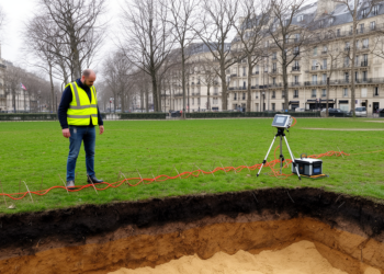
Electrical Resistivity Tomography Reveals Hidden Structure of Urban Soils Near Paris
A geophysical imaging study near Paris shows that electrical resistivity tomography can objectively classify urban soil units and guide stratified ...
A geophysical imaging study near Paris shows that electrical resistivity tomography can objectively classify urban soil units and guide stratified ...

Researchers have created a fast apparent resistivity-depth imaging algorithm that converts semi-airborne tipper electromagnetic data into rapid subsurface maps for ...
Researchers at Shengli Geophysical Research Institute of Sinopec have developed a faster 3D ray-tracing method for transversely isotropic media that ...
An integrated survey combining drone photogrammetry, ground magnetometry and gamma-ray spectrometry has traced anomalous gold in stream sediments of southern ...
A new study combines electrical resistivity and gravity surveys to map fractured basalt aquifers in Ethiopia, showing that groundwater occurrence ...
A new geophysical survey of 17 sites in Uttarakhand's Tanakpur area has mapped hidden Himalayan foothill aquifers using vertical electrical ...
A new processing strategy that interpolates irregular seismic shot points onto a regular 100-meter grid has dramatically sharpened deep crustal ...
High-resolution seismic surveys in Italy's Ossola Valley have mapped the bedrock beneath two planned boreholes of the ICDP DIVE project, ...
New research shows that simple electrical conductivity measurements can track how drying soils constrain microbial respiration through the connectivity and ...
A new comparative study tests four Markov Chain Monte Carlo algorithms on synthetic and real Venezuelan oilfield data, showing that ...

Embark on a thrilling journey of discovery with Scienmag.com—your ultimate source for cutting-edge breakthroughs. Immerse yourself in a world where curiosity knows no limits and tomorrow’s possibilities become today’s reality!