In a groundbreaking study, researchers have harnessed advanced remote sensing and Geographic Information Systems (GIS) technologies to map landslide susceptibility in the Chittagong Hill Tracts of Bangladesh. This innovative work, led by Hossain and his team, utilizes machine learning algorithms to create a comprehensive susceptibility map, which is essential for sustainable land management practices in this geologically dynamic region. With landslides posing a significant threat to both lives and infrastructure, the study aims to provide critical insights that could mitigate risks associated with these natural disasters.
The Chittagong Hill Tracts, which boast a unique landscape with diverse ecosystems, are regularly affected by landslides triggered by heavy rainfall, deforestation, and human activities. Recognizing the urgent need for effective risk assessment, the researchers employed machine learning to analyze various predictive factors such as topography, land use, and precipitation patterns. By integrating these factors, the study constructs a robust model that predicts areas most at risk of landslides, thereby informing disaster preparedness measures.
In their approach, the researchers utilized several machine learning techniques, including decision trees, random forests, and support vector machines. Each model was evaluated for its accuracy and reliability in predicting landslide-prone areas. This methodological diversity not only enhances the credibility of the findings but also illustrates the potential for machine learning in environmental studies. Such sophisticated modeling provides a more nuanced understanding of the interplay between human activity and natural processes that lead to landslides.
Data was collected from numerous sources, including satellite imagery and historical landslide records, allowing the researchers to construct a powerful dataset that reflects current conditions and past events. This comprehensive dataset serves as the foundation for the study, ensuring that the machine learning models are trained on relevant and diverse examples. The integration of remote sensing data proves invaluable, as it allows for large-scale analysis that would be challenging to achieve through traditional field studies alone.
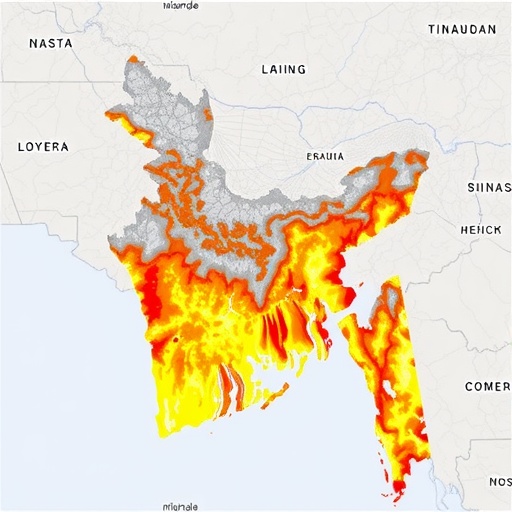
The resulting landslide susceptibility map generated by the researchers is a visual representation of vulnerability across the Chittagong Hill Tracts. This map not only identifies high-risk areas but also highlights regions where proactive measures can be taken to reduce risk and enhance community resilience. By prioritizing areas for intervention, local authorities can implement more effective land management strategies that align with sustainable development goals.
Moreover, the study emphasizes the importance of collaboration among stakeholders, including government agencies, local communities, and environmental organizations. Engaging these groups in the planning and implementation process is crucial for fostering a culture of safety and preparedness. The researchers advocate for the use of their findings to guide policy decisions, land-use planning, and community education programs focused on landslide risk reduction.
In addition to practical applications, the research contributes to the broader scientific understanding of landslide dynamics in the region. It provides a framework that could be adapted for use in other similar environments worldwide, demonstrating the versatility and applicability of machine learning in geographical studies. This points to a promising future where technological advancements can lead to improved disaster risk reduction strategies globally.
As climate change continues to influence weather patterns and increase the frequency of extreme weather events, the importance of such research becomes more pronounced. The findings from Hossain and his team’s study serve as a crucial reminder of the need for adaptive management practices in vulnerable regions. By anticipating potential hazards, communities can better prepare and respond to the challenges posed by natural disasters.
The implications of this research extend beyond immediate land management practices; they underline the intersection of technology and environmental stewardship. The successful implementation of such machine learning models demonstrates the potential of data-driven decision-making in mitigating the impacts of climate change. As we move forward, the integration of cutting-edge technology in environmental studies will be essential in building resilience against natural disasters.
In conclusion, the integration of remote sensing, GIS, and machine learning in landslide susceptibility mapping represents a significant advancement in sustainable land management practices. This study not only provides a critical tool for risk assessment but also fosters a deeper understanding of the complex interactions between various environmental factors contributing to landslides. As researchers continue to innovate, the hope is that their findings will inspire proactive measures that protect communities and promote sustainable land use in fragile ecosystems.
The research conducted by Hossain et al. is a vital contribution to the field of environmental science, illustrating the powerful role of technology in addressing complex challenges. The potential for these methods to revolutionize how we approach disaster management and sustainability is vast. As awareness of the threats posed by climate change grows, so too does the importance of studies that seek to create safer, more sustainable communities. The legacy of this work may well be measured in lives saved and disasters averted as we strive toward a more resilient future.
Subject of Research: Landslide susceptibility mapping using machine learning
Article Title: Remote sensing and GIS-driven landslide susceptibility mapping using machine learning for sustainable land management: a study from the Chittagong Hill Tracts of Bangladesh.
Article References:
Hossain, M.I., Ferdous, M.N., Bhattacharjee, S. et al. Remote sensing and GIS-driven landslide susceptibility mapping using machine learning for sustainable land management: a study from the Chittagong Hill Tracts of Bangladesh.
Discov Sustain 6, 1200 (2025). https://doi.org/10.1007/s43621-025-02084-x
Image Credits: AI Generated
DOI: https://doi.org/10.1007/s43621-025-02084-x
Keywords: Landslide susceptibility, remote sensing, GIS, machine learning, sustainable land management, Chittagong Hill Tracts, disaster risk reduction.
