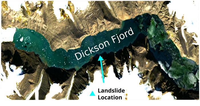
In the remote and icy expanses of East Greenland, a peculiar geophysical phenomenon captured the attention of scientists worldwide. Beginning in September 2023, seismic sensors around the globe detected a highly unusual signal that recurred with eerie regularity every 90 seconds over a span of nine days. After a pause, this mysterious seismic signature re-emerged a month later. These signals, persistent yet baffling, defied conventional explanations until recent breakthroughs shed light on their enigmatic origin.
For months, the scientific community grappled with the source of these rhythmic seismic pulses. Two independent studies converged on a compelling hypothesis: these signals were generated by colossal mega-tsunamis triggered by massive landslides in a remote fjord of East Greenland. These catastrophic landslides were themselves a consequence of warming-induced destabilisation of a glacier perched above the fjord. The forces unleashed in these slides caused enormous waves to surge through the confined waters, unlike typical tsunamis that travel vast ocean distances. Instead, these waves became trapped within the intricate fjord system, oscillating back and forth, creating standing waves known as seiches.
Despite the strong theoretical groundwork, tangible evidence of these seiches had been elusive. Notably, even a Danish military vessel dispatched to the fjord during the height of the first seismic event failed to witness the wave phenomena. Conventional observation methods and satellite technology, until now, lacked the spatial and temporal resolution to capture the dynamic behaviors of these transient but powerful waves within such a constricted and complex environment.
The breakthrough came courtesy of novel analysis techniques applied by researchers at the University of Oxford to an emergent class of satellite data. Traditional satellite altimeters operate by emitting radar pulses beneath the satellite and measuring their return time to estimate surface heights along straightforward, one-dimensional paths. This paradigm suffers from significant limitations: temporal gaps between observations and paucity of cross-sectional spatial data prevent thorough monitoring of transient ocean surface events like seiches.
Enter the Surface Water Ocean Topography (SWOT) satellite, launched in December 2022 with a mission to revolutionize water surface mapping across 90 percent of the Earth’s surface. At the heart of SWOT lies the Ka-band Radar Interferometer (KaRIn), an innovative instrument featuring two antennas spaced ten meters apart on a boom extending laterally from the satellite body. These antennas employ radar interferometry, a technique that uses phase differences in the return radar waves to create high-resolution, two-dimensional elevation maps of water surfaces across a broad swath approximately 50 kilometers wide. This lateral coverage and precision—down to approximately 2.5 meters—enabled unprecedented observations of dynamic oceanic and surface water phenomena.
Applying KaRIn data, researchers constructed detailed temporal elevation maps of the Greenland fjord during and after the two mega-tsunami events. These maps revealed pronounced cross-channel slopes indicative of water displacement of up to two meters in height, oscillating back and forth. The directionality and timing of these oscillations aligned impeccably with the previously detected seismic signals. The observed standing wave patterns were clear signatures of seiches reverberating through the fjord’s confined waters.
To cement their findings, the team correlated these surface water oscillations with minute deformations in the Earth’s crust captured thousands of kilometres away by seismic stations. This correlation allowed them to reconstruct the wave dynamics even during intervals when satellite coverage was absent. Moreover, rigorous modelling of concurrent atmospheric and tidal conditions ruled out alternative explanations such as wind-generated waves or tidal fluctuations, reinforcing the landslide-induced tsunami-seiche hypothesis.
Lead author Thomas Monahan, a doctoral student in Oxford’s Department of Engineering Science, emphasized the broader implications of their findings. "Climate change is ushering in novel extreme events that are especially pronounced in remote and fragile Arctic environments. Our capacity to understand these processes has been historically limited due to challenges in physical monitoring. However, tools like SWOT offer an unprecedented window into these elusive phenomena," he said. Monahan stressed how satellite technologies can bridge crucial observation gaps in these rapidly evolving systems.
Co-author Professor Thomas Adcock highlighted the transformative potential of next-generation satellite data for oceanography. "This study exemplifies how advances in remote sensing unlock insights into natural phenomena previously shrouded in mystery. Satellites equipped with cutting-edge instruments pave the way for better understanding hazards like tsunamis, storm surges, and freak waves, which have profound societal implications," Adcock remarked. He further underscored the role of integrating machine learning with fundamental ocean physics to maximize the value of these new data streams.
The Greenland fjord mega-tsunami events stand as a stark reminder of the cascading effects of climate warming on Earth’s cryosphere and its interconnected geophysical processes. Glacier destabilization and resulting mega-landslides may trigger extreme wave events with widespread environmental and seismic consequences, potentially magnifying natural hazards in polar regions. Their detection and characterization necessitate a fusion of innovative sensing technologies and interdisciplinary analysis.
This research not only marks a milestone in glacial and oceanic geophysics but also underscores the power of satellite radar interferometry for dynamic Earth observation. By mapping transient water surface disturbances with high spatial and temporal fidelity, novel satellites like SWOT usher in a new era for monitoring and understanding complex natural phenomena in previously inaccessible settings.
As climate change continues to reshape polar landscapes, the ability to detect, analyse, and predict associated extreme events will be vital for scientific knowledge and hazard mitigation. The integration of satellite remote sensing, ground-based seismic data, and advanced computational methods heralds promising prospects for future discoveries and environmental stewardship.
Oxford University’s pioneering research thus illuminates the intricate choreography of water, ice, and earth in a warming world, revealing hidden dynamics through the lens of next-generation space technology. Their findings, soon to appear in Nature Communications, invite the global scientific community to recalibrate our understanding of oceanic extremes under climate stress and to develop adaptive strategies for the challenges ahead.
Subject of Research: Observations and analysis of seismic signals linked to mega-tsunamis and seiches in East Greenland fjords induced by glacier warming and landslides.
Article Title: Observations of the seiche that shook the world
News Publication Date: 3 June 2025
Web References:
- Surface Water Ocean Topography (SWOT) satellite: https://swot.jpl.nasa.gov/
- DOI link to article: http://dx.doi.org/10.1038/s41467-025-59851-7
Image Credits: Copernicus Sentinel-2 satellite image of the Dickson Fjord in East Greenland. Credit: Thomas Monahan.
Keywords: seiche, mega-tsunami, Greenland fjord, glacier warming, landslide, satellite altimetry, SWOT satellite, Ka-band Radar Interferometer, oceanography, climate change extremes, remote sensing, Earth observation
