California’s Coastline Shows Surprising Resilience Amid Changing Climate: New Research Illuminates Beach Dynamics
A pair of groundbreaking studies from the renowned Scripps Institution of Oceanography at UC San Diego provides an optimistic outlook on the stability and resilience of California’s beaches, a critical natural barrier protecting the coastline from rising seas and extreme weather phenomena. These investigations, encompassing both detailed local assessments and expansive statewide analyses, shed new light on the complex interplay of natural forces shaping one of the world’s most iconic coastlines.
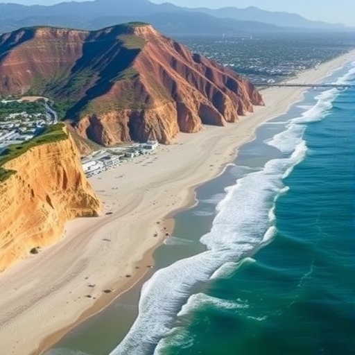
The localized study, articulated through the 2025 San Diego County Beach Report, offers a comprehensive evaluation of beach width fluctuations across nine frequently monitored beaches stretching from Carlsbad to the southern border of California. Utilizing Light Detection and Ranging (LiDAR) technology mounted on trucks, all-terrain vehicles, and drones, researchers acquire high-resolution three-dimensional measurements every month. This technology fires rapid laser pulses at the ground, calculating distance by timing the reflections, enabling detailed mapping of erosion and accretion patterns. The datasets, collected between October 2024 and September 2025, reveal a hopeful trend: most San Diego beaches experienced net widening during this period following a post-El Niño recovery phase.
Beach width is an essential metric, acting as the front line against storm surges and coastal flooding. According to Adam Young, a leading coastal geomorphologist at Scripps, maintaining robust and healthy beaches plays a vital role not only in natural defense but also in sustaining recreational, cultural, and economic activities dependent on accessible and stable shorelines. This work, supported by California State Parks and funded in part by federal Community Project Funding championed by U.S. Representative Mike Levin, equips coastal managers with critical data that informs potential beach nourishment projects. Such interventions involve adding sand to combat erosion, which is particularly valuable after years when natural replenishment lags.
Declining beach widths often follow El Niño events, which are characterized by greater oceanic wave energy that strips sand from beaches and deposits it offshore. The most recent findings, however, convey a phase of natural rehabilitation, indicating that following the subdued 2023-2024 El Niño, most beaches are now regaining lost territory. The team cautions, though, that the path to full recovery is precarious, especially considering that erratic weather events like atmospheric rivers, which deluge the coast with intense rainfall and waves, could disrupt these gains. The failure of the previous recovery period (2016 to 2024), which saw continuous narrowing despite the absence of consecutive El Niño years, underscores the influence of such episodic disturbances on coastal morphology.
An interesting nuance highlighted by the report is the role of artificial beach nourishment projects, particularly in Encinitas and Solana Beach, which have contributed to measurable sand accretion. Notably, the artificially supplied sand tends to migrate southward over time, altering regional sediment dynamics. It’s worth noting that despite concerns about climate change accelerating erosion, no definitive trend attributable to rising temperatures has yet been detected in San Diego County, largely due to the relatively short duration of detailed, continuous monitoring.
Expanding the scope beyond regional analysis, a statewide study led by Scripps researchers employed satellite imagery spanning 36 years—from 1985 to 2021—captured by NASA and the U.S. Geological Survey’s Landsat program. Using an advanced software toolkit known as CoastSat, which algorithmically detects the intersection between the ocean and dry sand, the research team systematically quantified changes in beach widths along California’s entire sandy coastline. Rocky shorelines and cliffs were excluded to ensure uniformity in beach-type analyses.
Surprisingly, the overarching conclusion of this expansive work was the remarkable stability of California’s average beach width over nearly four decades. This constancy defied expectations given the documented declines in sediment delivery from rivers—many of which are dammed or diverted—and specific locales known for sustained erosion. Lead author William O’Reilly emphasized that although certain beaches have experienced significant sand loss, these losses are often offset by accretion elsewhere, effectively redistributing sediment along the coast. Some areas, including the south end of Camp Pendleton, Venice Beach, and northern Ocean Beach in San Francisco, are gaining sand, while others like Oceanside and San Clemente are in decline.
The phenomenon of redistribution highlights a dynamic system governed by complex coastal processes that are not yet fully understood. Sediment transport by ocean currents, wind patterns, and wave energy likely plays a multifaceted role in this reshuffling, creating localized “winners” and “losers.” This insight is critical because it suggests that ecosystem resilience might be higher than previously thought, offering some commensurate hope even as global sea-level rise threatens coastal systems worldwide.
Future climate change-induced challenges, particularly sea-level rise, are expected to complicate these patterns further, potentially overwhelming the natural sedimentary processes that currently help maintain beach widths. However, the persistence of substantial sand volumes close to shore—even following intense El Niño storms—suggests mechanisms exist for natural recovery over several years. Sediment temporarily displaced offshore can re-deposit on beaches when conditions favor accretion, underscoring the importance of monitoring not just beach widths but also nearshore sediment stores.
Together, these two studies provide critical temporal and spatial perspectives on California’s coastal resilience. The San Diego County Beach Report affords granular, frequent data essential for near-term coastal management and policy-making decisions, especially in the allocation of resources for beach nourishment or other mitigation strategies. Simultaneously, the statewide satellite analysis offers a macroscopic view that tempers fears of unchecked erosion, revealing an intricate balance of erosional losses and accretion gains across California’s diverse beach environments.
The implications of these findings are profound. Understanding that California’s beaches have exhibited an unexpected degree of natural resilience should inspire further scientific exploration into the drivers behind sediment redistribution and the thresholds beyond which resilience might fail. Additionally, it emphasizes the need for sustained, long-term monitoring systems that combine airborne remote sensing, ground-based surveys, and satellite observations to capture the full complexity of coastal dynamics.
With sea-level rise expected to accelerate and oceanographic conditions becoming increasingly erratic due to climate change, this research highlights the urgency of proactive coastal management. Maintaining and restoring beach systems not only safeguards human infrastructure and livelihoods but also preserves vital habitats supporting a rich biodiversity. The studies underscore that while technological interventions such as nourishment can aid recovery, the fundamental forces of wave energy and sediment transport remain dominant architects of shoreline morphology.
In conclusion, California’s beaches remain a living testament to the dynamic equilibrium of natural coastal processes. Science-driven monitoring and innovative data analysis tools, as exemplified by these studies, allow us to better understand this balance and inform policies that enhance coastal resilience in an era of unprecedented environmental challenges. As these sandy shores continue to evolve, scientists, policymakers, and communities must collaborate to ensure their preservation for generations to come.
Subject of Research: Not applicable
Article Title: Interannual Wave-Driven Shoreline Change on the California Coast
News Publication Date: 17-Nov-2025
Web References:
- 2025 San Diego County Beach Report
- Nature Communications Study
- Landsat Program
- CoastSat Software Toolkit
References:
- O’Reilly, W.C., Merrifield, M., Young, A., et al. “Interannual Wave-Driven Shoreline Change on the California Coast,” Nature Communications, November 17, 2025.
Image Credits: Credit: Erik Jepsen/UC San Diego
Keywords: Coastal processes, Beaches
