In a groundbreaking advancement poised to revolutionize oceanographic research, scientists have unveiled a novel technique for mapping ocean surface currents with unprecedented detail and scale. This new method, known as GOFLOW (Geostationary Ocean Flow), leverages deep learning applied to thermal imagery collected from existing geostationary weather satellites, enabling high-resolution, near-real-time observation of ocean currents without necessitating any additional hardware launches. This pivotal breakthrough stands to vastly enhance our fundamental understanding of dynamic ocean circulation patterns, with far-reaching implications across climatology, marine biology, and environmental monitoring.
The GOFLOW approach emerged from the collaborative efforts of oceanographers and data scientists, including Luc Lenain from the Scripps Institution of Oceanography at UC San Diego and Kaushik Srinivasan, a Scripps alumnus now at UCLA. Their findings were published in the esteemed journal Nature Geoscience on April 13, 2026, highlighting the electrifying potential of combining machine learning with the copious wealth of satellite thermal data that has been previously underutilized for ocean current analysis.
Ocean currents are integral to regulating Earth’s climate system by transporting heat and redistributing carbon and nutrients across vast distances. However, capturing their spatial and temporal variability has remained a formidable challenge. Traditional satellite-based methods primarily rely on sea surface height variations as proxies for current velocities, providing data only every 10 days or longer. Complementary in-situ techniques, such as shipborne instruments and coastal radar, though accurate, are inherently limited to narrow geographical corridors and cannot offer the expansive coverage needed to understand mesoscale and submesoscale ocean dynamics that evolve over just hours.
This paucity of comprehensive observational data has long hindered the scientific community’s ability to explore critical processes like vertical mixing, which facilitates the exchange of nutrients and gases between ocean layers. Such vertical exchanges, occurring at scales often less than 10 kilometers and varying rapidly, are essential for sustaining marine ecosystems and modulating the ocean’s role as a carbon sink. The ability to resolve these transient small-scale features has been confined largely to sophisticated numerical simulations — until now.
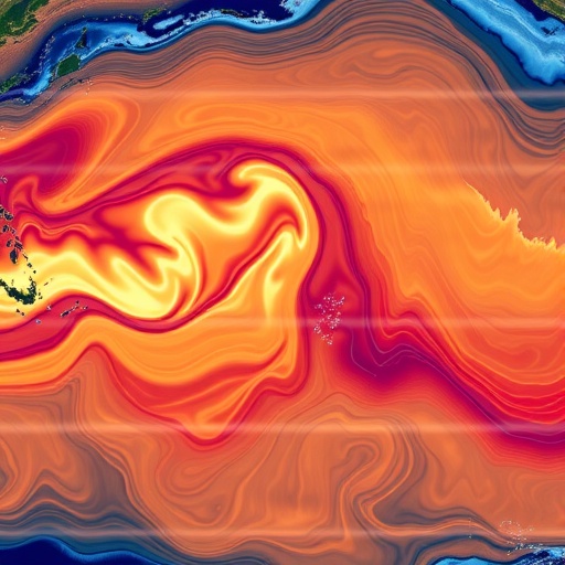
Intrigued by the high-frequency thermal imagery from the GOES-East satellite, primarily designed for atmospheric monitoring, Lenain recognized striking patterns of temperature gradients on the ocean surface that mirrored underlying current motions. This satellite captures images every five minutes, offering a dense temporal dataset that, if decoded correctly, could reveal currents in near real time. However, interpreting these subtle thermal patterns required an innovative analytical framework, which precipitated the integration of neural networks trained on high-resolution ocean circulation models.
The core of GOFLOW is a neural network algorithm developed to identify and track the deformation and advection of temperature patterns at the ocean surface. By ingesting pairs or sequences of consecutive thermal images, the network learned the complex relationship between evolving temperature features and the velocity fields that generate them. This approach essentially translates visible thermal patterns into quantitative flow maps, an unprecedented capability accomplished solely through advanced machine learning techniques grounded in physical oceanography simulations.
Testing GOFLOW against observed data was pivotal in validating its accuracy and robustness. The team compared GOFLOW-derived current maps with velocity measurements from ship-based instruments in the Gulf Stream region, a globally significant and dynamically complex current. The comparisons demonstrated excellent agreement, affirming the model’s capacity to resolve fast-evolving, small-scale eddies and boundary layers, which appear blurred or undetected in conventional satellite datasets.
This enhanced granularity enabled, for the first time, the characterization of key statistical signatures associated with intense, small-scale currents that are instrumental in driving vertical mixing processes. These currents, hitherto documented only in numerical experiments, can now be empirically measured, opening new pathways for investigating ocean-atmosphere interactions that influence weather systems, climate variability, and marine biogeochemical cycles.
Lenain emphasized the transformative nature of GOFLOW, stating that it bridges a critical gap between simulation-based hypotheses and real-world observations. By providing real-time measurements of ocean surface currents at previously unattainable resolutions, GOFLOW empowers scientists to test and refine long-standing theories about heat and carbon uptake in the oceans, which are fundamental to understanding and predicting climate change impacts.
A major advantage of GOFLOW is its reliance on data from existing geostationary satellites, making it both cost-effective and scalable. Unlike methods that require new satellite deployments or specialized instrumentation, this technique can be implemented immediately across all regions covered by such satellites, with the potential for integration into operational weather forecasting and climate modeling frameworks. By resolving currents that evolve rapidly, GOFLOW could enhance predictive models related to air-sea gas exchange, pollutant dispersion, and ecosystem dynamics.
Despite its remarkable capabilities, GOFLOW is not without limitations. Cloud cover poses significant challenges as it obstructs satellite thermal imagery, resulting in data gaps. To overcome this, the research team plans to incorporate complementary satellite datasets operating in different spectral ranges, enabling continuous monitoring even under cloudy conditions. Furthermore, efforts are underway to expand the methodology globally, thus providing a comprehensive, high-resolution ocean flow atlas on a planetary scale.
An integral facet of this project is its commitment to open science. The researchers are releasing their computational code and data products to the scientific community, facilitating further investigation, validation, and diverse applications ranging from marine conservation to naval operations. This democratization of data and tools promises to accelerate innovation and collaboration across disciplines.
The advent of GOFLOW heralds a new era in oceanography where machine learning and satellite remote sensing coalesce to illuminate the ocean’s intricate circulation patterns in unprecedented detail. This breakthrough has the potential to redefine our understanding of the oceans’ role in Earth’s system, enhancing climate resilience strategies and the stewardship of marine resources in an era of rapid environmental change.
Subject of Research: Not applicable
Article Title: An unprecedented view of ocean currents from geostationary satellites
News Publication Date: 13-Apr-2026
Web References: https://www.nature.com/articles/s41561-026-01943-0
References:
Lenain, L., Srinivasan, K., Barkan, R., & Pizzo, N. (2026). An unprecedented view of ocean currents from geostationary satellites. Nature Geoscience. DOI: 10.1038/s41561-026-01943-0
Image Credits: Luc Lenain/Scripps Institution of Oceanography
Keywords: Oceanography, satellite remote sensing, machine learning, ocean currents, vertical mixing, GOFLOW, GOES-East, Gulf Stream, physical oceanography, climate science
