A groundbreaking advancement in the cartographic representation of ancient infrastructure has been unveiled through the creation of Itiner-e, a high-resolution digital dataset encompassing the extensive road network of the Roman Empire around 150 CE. This meticulously crafted resource marks a significant leap forward in the scale and precision of Roman road mapping, revealing an expansion of over 100,000 kilometers beyond previous estimations. Itiner-e not only broadens our spatial understanding of Roman connectivity but also sets a new standard for digital archaeology and historical geography.
At the apex of its territorial expanse in the second century CE, the Roman Empire governed a diverse population exceeding 55 million individuals, sprawling from the distant reaches of Britain in the northwest to the vast landscapes of Egypt and the Levant in the southeast. Central to managing this vast empire was a sophisticated and far-reaching network of roads, serving as vital arteries for military, administrative, commercial, and cultural exchange. Despite the acknowledged importance of these roads, prior efforts to map the network have been hampered by low-resolution data and incomplete digitizations, leaving substantial knowledge gaps about the Empire’s infrastructure.
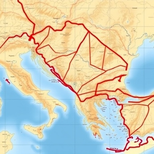
The creation of Itiner-e is the result of a multidisciplinary collaboration led by researchers including Tom Brughmans, Pau de Soto, and Adam Pažout, who integrated a diverse range of sources such as archaeological findings, historical accounts, detailed topographic maps, and advanced satellite imagery. This integrative methodology allowed the graduate precision and contextual accuracy necessary for reconstructing road trajectories that respect the geographical realities of the ancient world. Notably, the dataset accounts for the serpentine nature of mountain passages, eschewing simplistic straight-line assumptions for more realistic routes that ancient travelers would have used.
Quantitatively, the Itiner-e dataset encompasses a staggering 299,171 kilometers of Roman roads, a substantial increase from the previously accepted figure of 188,555 kilometers. This revised inventory covers an area spanning nearly four million square kilometers, representing an unprecedented level of geo-referenced detail. Spatially, the augmented road coverage emerges predominantly from more comprehensive data for regions such as the Iberian Peninsula, Greece, and North Africa, where earlier maps had underestimated the complexity and extent of road systems.
Further refinement within the dataset categorizes these roads into primary and secondary classifications, with the former totaling 103,478 kilometers—approximately 34.6% of the network—while secondary roads constitute the majority at 195,693 kilometers or 65.4%. These distinctions are vital for understanding the Roman road system’s hierarchy and functional differentiation, reflecting varying degrees of traffic density, construction standards, and strategic importance. By furnishing such granularity, Itiner-e affords historians and archaeologists nuanced tools to analyze the empire’s logistical and administrative organization.
One of the notable challenges confronted by the creators of Itiner-e lies in the inherent uncertainty surrounding the exact locations of many roads. The dataset estimates that only 2.7% of roads have been pinpointed with high certitude, reflecting how scarce and fragmentary direct archaeological evidence can be. A considerable 89.8% are situated with less precise certainty, often reconstructed through inferential models balancing historical itineraries and environmental constraints, whereas 7.4% represent hypothesized routes where corroborative evidence remains elusive. This transparency regarding data certainty underscores both the scientific rigour of the project and the continuing need for further empirical verification.
Importantly, Itiner-e is more than a static map; it acts as a dynamic, openly accessible platform for a broad spectrum of interdisciplinary research inquiries. The authors emphasize its utility in exploring fundamental questions about Roman imperial connectivity, the mechanisms of territorial administration, patterns of migration, and the dissemination of diseases across the empire’s vast domains. These applications resonate with contemporary interests in how infrastructure shapes societal resilience and vulnerability, drawing valuable parallels between ancient and modern dynamics.
Despite its transformative scope, the Itiner-e dataset has specified limitations. The dataset captures a snapshot primarily reflective of the mid-second century CE road network and does not delineate the evolutionary changes these roads underwent over time. Roman roads were subject to continuous repairs, rerouting, and expansions aligned with shifting political borders, military campaigns, and regional developments, and understanding these temporal dynamics remains a critical challenge. Future research building on Itiner-e could incorporate chronological layering to unpack the diachronic development of the Empire’s infrastructure.
From a technical perspective, Itiner-e leverages cutting-edge geographic information system (GIS) techniques, combining vector-based spatial data with metadata about road certainty, road classification, and elevation profiles. The integration of satellite imagery analysis, particularly through remote sensing technologies capable of detecting subtle landscape modifications, enables the identification of previously undocumented road segments. Moreover, the adaptation of routes to mountainous terrains through non-linear path adjustments demonstrates a sophisticated appreciation of ancient engineering constraints and environmental adaptation strategies.
This research also exemplifies the expanding role of ‘big data’ and computational methodologies in classical studies and archaeology. Traditionally reliant on fragmentary textual sources and localized excavations, the discipline now benefits enormously from scalable digital infrastructures that facilitate comprehensive and reproducible analyses. As a fully open dataset, Itiner-e invites contributions and refinements from the global research community, fostering collaborative validation and iterative enhancement of the Roman road map.
The implications of Itiner-e extend into practical applications beyond academia. For instance, heritage preservation efforts can utilize detailed road mappings to prioritize excavation sites or protect vulnerable archaeological remains. Additionally, it may serve as an educational tool to deepen public fascination with Roman history, illustrating the logistical grandeur underpinning one of history’s most influential empires. Digital visualizations based on Itiner-e have potential to captivate broad audiences through immersive simulations or virtual reconstructions of Roman travel and commerce.
This new dataset also underscores the importance of interdisciplinary approaches, combining classical studies, archaeology, geography, and computer science. By synthesizing these domains, the research team has produced a dataset that not only enriches historical knowledge but also exemplifies how digital humanities can transform our understanding of ancient worlds. The methodology employed is likely to inspire similar projects targeting other large ancient networks such as roadways, aqueducts, and maritime routes.
In conclusion, Itiner-e stands as a monumental achievement in the digital reconstruction of ancient infrastructure, showcasing the power of modern technology fused with classical expertise to dramatically enhance our comprehension of the Roman Empire’s spatial organization. While certain uncertainties and limitations remain, this dataset lays a robust foundation for future explorations into the empire’s impact on connectivity, administration, and socio-economic dynamics over an unprecedented geo-spatial scale. As the digital humanities continue to evolve, resources like Itiner-e will be instrumental in bridging past and present, enabling new narratives about the engineering prowess and societal complexity of antiquity.
Subject of Research: High-resolution mapping and digitization of the Roman Empire’s road network
Article Title: Itiner-e: A high-resolution dataset of roads of the Roman Empire
News Publication Date: 6-Nov-2025
Web References:
10.1038/s41597-025-06140-z
Keywords: Roman Empire, Roman roads, archaeological GIS, digital humanities, ancient infrastructure, spatial datasets, historical geography, remote sensing, digital archaeology
