For the past three years, archaeologist Greer Jarrett of Lund University in Sweden has embarked on a remarkable journey, retracing the maritime routes of the Vikings with extraordinary scientific rigor and hands-on experimentation. His research challenges long-standing views by demonstrating that Vikings ventured much farther from Scandinavia and navigated open seas at greater distances from land than previously assumed. Through a combination of experimental sailing, digital landscape reconstructions, and ethnographic analogy, Jarrett unveils a sophisticated Viking Age maritime network marked by decentralized ports on islands and peninsulas, which played critical roles in facilitating trade and communication across the North Atlantic.
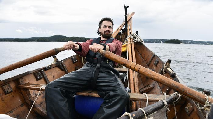
Central to Jarrett’s research is the use of a meticulously crafted open, square-rigged clinker boat modeled closely after vessels from the Viking Age, spanning roughly 800 to 1050 AD. This craft embodies the agility and robustness integral to Viking seafaring, enabling navigation in a variety of marine conditions. During his project, Jarrett’s team embarked on arduous voyages covering over 5,000 kilometers, from Trondheim to Arctic Circle waters and beyond, closely following the inferred paths of ancient mariners. These sea trials revealed that such vessels are not only capable of enduring harsh open-water conditions but also exhibit remarkable stability despite lacking a deep keel, a feature traditionally associated with stability in modern sailboats.
Navigating in Viking times presented complex challenges, especially in confined fjords and coastal passages. Jarrett’s expeditions have illuminated how environmental factors—such as underwater currents and katabatic winds descending from mountain slopes—significantly impacted sailing conditions. These subtle and often unpredictable forces demanded a profound understanding of local geography and meteorology. Jarrett’s firsthand experience underscores that maneuvering near land required as much skill and attention as open-ocean sailing, illustrating a complex seafaring skill set that modern researchers often underestimate.
In addition to experimental sailing, Jarrett augmented his research by interviewing Norwegian sailors and fishermen who navigated without engines in the 19th and early 20th centuries. These interviews provided invaluable insights into traditional knowledge and route choice, shedding light on how empirical, passed-down understanding of sea routes might mirror Viking navigation strategies. The oral histories and local lore preserved among these communities helped Jarrett reconstruct potential Viking Age sailing itineraries with greater fidelity, bridging historical practice with experiential archaeology.
A groundbreaking insight from Jarrett’s work is the concept of the “Maritime Cultural Mindscape”—a network of myths, stories, and mental maps that Vikings used to navigate without modern instruments such as maps, compasses, or sextants. Instead, sailors relied heavily on a cognitive framework grounded in place-based narratives tied to specific coastal landmarks. For example, tales about islands like Torghatten, Hestmona, and Skrova doubled as navigational aides, warning of hazards or signaling crucial waypoints. This intangible cultural system served as a mnemonic device for recalling dangers and navigation cues, demonstrating sophisticated cognitive mapping ingrained within Viking communities.
One of the most compelling contributions of Jarrett’s study is the identification of previously unrecognized potential Viking harbours—termed “havens”—along Norway’s rugged coastline. Unlike major known ports such as Bergen or Trondheim, these havens are situated farther offshore on islands and peninsulas, offering strategic advantages for Viking seafarers. Jarrett’s combined methodology, blending experiential data from his sailing trials and digital topographical reconstructions of the Viking Age landscape, highlights how these localized havens likely functioned as essential waypoints. Their accessibility in varying wind conditions and shallow waters accommodated the shallow-drafted nature of clinker boats, enabling efficient stops during long maritime journeys.
Jarrett’s fieldwork was not without peril. During one notably dramatic incident in May 2022, the yard holding up the mainsail broke while they were navigating Vestfjorden, approximately 25 kilometers offshore. The crew’s responsive ingenuity—lashing two oars together to replace the spar—ensured their survival and successful return to port. Such episodes not only add an element of adventure to the research but also underscore the precarious nature of Viking voyages and the critical importance of adaptability and cooperation within crews.
This leads directly into another critical element of Viking maritime enterprise: the social dimensions of sailing. Jarrett emphasizes that beyond the physical properties of boats and environmental challenges, the success of Viking expeditions hinged on the cohesiveness and skill of the crews. Prolonged voyages demanded endurance under harsh weather, requiring tight-knit cooperation amid potentially life-threatening situations. Jarrett’s voyages reaffirm that the combination of resilient vessels and capable, coordinated crews formed the backbone of Viking sea power.
Another intriguing dimension of Jarrett’s broader research investigates Viking trade networks, which historically have been understood primarily through the lens of major trading centers. Jarrett’s hypothesis posits that a broad network of smaller, decentralized ports played a pivotal role in facilitating trade and cultural exchange. These secondary ports, dispersed across minor islands and peninsulas, constituted critical nodes in a dynamic seafaring infrastructure, nurturing both commerce and communication. This challenges older, more centralized models of Viking maritime trade by emphasizing the significance of decentralized connectivity and intermittent stopping points.
Jarrett’s studies also intersect with environmental history and coastal geomorphology through digital reconstructions of the Viking Age coastline, accounting for post-glacial sea-level changes and sedimentation patterns. These models allow researchers to visualize ancient landscapes and understand how navigational routes may have shifted over centuries. Such digital methodologies augment experiential data and offer a holistic framework for comprehending Viking maritime itineraries in both space and time.
The implications of Jarrett’s findings extend beyond Viking studies, providing new perspectives on pre-modern maritime technology and navigation. His interdisciplinary approach—blending rigorous fieldwork, historical ethnography, experimental archaeology, and digital modeling—offers a blueprint for future research into ancient seafaring cultures worldwide. By demonstrating how small vessels combined with cognitive mapping and traditional knowledge enabled extensive oceanic voyages, Jarrett’s work reshapes our understanding of human interaction with maritime environments.
In summation, Greer Jarrett’s innovative research not only revives the spirit of Viking exploration but also embeds it within a contemporary scientific context. His voyages exemplify how experimental archaeology can yield tangible insights into the challenges and triumphs of ancient navigation. The realization of a decentralised network of coastal havens alters existing paradigms on Viking Age maritime logistics, suggesting a more complex and adaptive model of seafaring. Jarrett’s work thus stands as a testament to the enduring human quest to master the seas through ingenuity, storytelling, and experiential knowledge.
Subject of Research: Viking Age Seafaring and Navigation; Experimental Archaeology of Viking Ships; Decentralized Maritime Networks
Article Title: From the Masthead to the Map: an Experimental and Digital Approach to Viking Age Seafaring Itineraries
Web References: http://dx.doi.org/10.1007/s10816-025-09708-6
Image Credits: Greer Jarrett
