


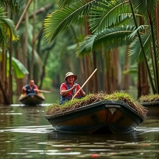
In the floodplain communities of the Peruvian Amazon, danger rarely announces itself through raw magnitude alone. A new study published in the journal Ambio argues that for people who live along the region’s winding rivers, the most disruptive hydrological events are those that arrive at the wrong time—too early, too late, or lasting too long relative to the seasonal rhythms that structure daily life. The research, led by Heidi D. Mendoza of the Institute for Environmental Studies at Vrije Universiteit Amsterdam together with an interdisciplinary team spanning Peru, the Netherlands, Germany, the United Kingdom, and France, introduces the concept of “risk windows”: recurring periods of heightened vulnerability that emerge not simply from floods or droughts themselves, but from the mismatch between actual river behavior and locally expected river behavior.
The study focuses on three riverine communities in Peru’s Loreto region, each situated on a different river system and each shaped by a distinct hydrological and social geography. Bajo Belén is an urban settlement on the banks of the Itaya River on the periphery of Iquitos, where residents depend on fishing and farming. Tamshiyacu is a semi-rural community on the Amazon River with an economy built around small-scale agriculture, commerce, and municipal employment. El Chino is a small, remote village on the Tahuayo River where livelihoods rest largely on artisanal fishing and handicrafts made from chambira palm fiber. All three live with the annual alternation of two locally named seasons: the vaciante, or low-water period, and the creciente, or high-water period. The researchers selected the sites because of their direct dependence on rivers for fishing, agriculture, and transport, and because all had experienced recent extreme events, including the record 2012 flood and the severe 2023 drought.
Methodologically, the team rejected the extractive conventions that have often characterized research on local environmental knowledge. Instead, they built the study around storytelling. Between May and June 2023, they conducted 45 individual storytelling sessions with fisherfolk, farmers, mothers, and elders across the three communities, using open-ended prompts such as “When does the vaciante start and how does your day-to-day change during this season?” and “How does drought or flood change your day-to-day?” All sessions were audio-recorded, transcribed, and coded inductively in Atlas.ti to identify recurring patterns in how river-dependent activities were discussed in relation to seasonality and uncertainty. From this initial analysis, the first author developed seasonal calendars that mapped key activities—fishing, planting, water collection, house maintenance—across the months of the year, revealing gaps and ambiguities such as divergent planting schedules for the same crops or disagreement over when the river typically turns.
In a second fieldwork phase in 2024, those co-produced seasonal calendars became analytical instruments. During one-on-one interviews, participants elaborated on their monthly activities and pinpointed the moments in the year when anticipating change was harder than usual. Risk windows were then identified through code co-occurrence analysis: periods where shifts in river dynamics overlapped with expressed uncertainty, disruption, or impact. Crucially, the researchers emphasized that the hydrological data they juxtaposed with these narratives—daily water levels from the ENAPU station on the Itaya River (1970–2023), the Tamshiyacu station on the Amazon River (1985–2023) supplied by SENAMHI, and El Chino station data (2023) from the Geophysical Institute of Peru—were not used to validate local knowledge against an allegedly superior scientific benchmark, but to place lived experiences of uncertainty within hydrological dynamics. This refusal to treat situated knowledge as merely raw material for expert verification runs through the entire paper and is framed explicitly as a matter of epistemic justice.
The hydrological analysis confirmed the extremity of the two anchor events. At the ENAPU station, where normal variability defined by the 1970–2023 climatology is around 7.75 meters, the 2012 flood reached the climatological maximum on March 13—47 days earlier than the expected date of April 29. During the 2023 drought, the climatological minimum arrived on August 10, 36 days earlier than usual. At Tamshiyacu, the 2012 maximum came 49 days early and the 2023 minimum 33 days early. In terms of annual extremes, the 2012 flood stands as the most severe maximum-level event in the analyzed record, exceeding the average maximum by 1.57 meters at ENAPU and 1.61 meters at Tamshiyacu, while the 2023 drought ranks as the sixth most severe minimum-level event on the Itaya and the third most severe at Tamshiyacu since 1985. Community members in El Chino, where the 2023 minimum ran 9.26 meters below that year’s maximum, reported that the drought surpassed anything in living memory.
Yet the heart of the paper lies in what the numbers cannot say. In Bajo Belén, residents described a normal vaciante running from June to November and a creciente from December to May, with agricultural decisions synchronized to receding water levels that expose farmland reachable only by 15- to 30-minute boat journeys. Farmers stagger plantings of plantain, corn, cassava, and coriander to hedge against river fluctuations, but an unusually extreme vaciante both suppresses yields and strands produce, as shallow water hinders boat transport from the chacras to urban markets. The community identified two principal risk windows in a normal year: April to June, when water peaks and flooding may strike, and September to December, when low water constrains transport, agriculture, and access to water. During the 2023 drought, these windows widened into crises of contaminated water, immobilized canoes, and accumulating riverside waste.
In Tamshiyacu, the agricultural system is spatially divided between zona baja, the low-lying floodplain where rice and maize are cultivated on the fertile mud left by receding water, and zona alta, the higher ground supporting perennials such as plantain and cacao alongside pineapple and cassava. Here the defining hazard is the repiquete—a sudden, unexpected rise in river level during the low-water season that can wash away freshly planted rice seedlings or drown young plants. “That is how we work in the jungle; that is how this year ends and the next year begins,” one farmer explained, adding that families now must seek faster-growing crops than their parents did. Community members identified May to June, the transition between creciente and vaciante, and August to October, when the river drops lowest and its variability feels greatest, as their risk windows. During the 2012 flood, water inundated not just the zona baja but parts of the zona alta, submerging rice entirely and leaving plantain underwater long enough to cut productivity; the 2023 drought compressed planting and harvesting opportunities and strained the municipal water system, which treats river water and suffers sediment-related interruptions after high-turbidity periods.
El Chino, the most isolated of the three, illustrated how geography converts hydrological anomaly into food insecurity. Fisherfolk there had already noticed declining catches and shrinking sizes of key species such as boquichico, palometa, and sabaló. When the 2023 drought kept water levels roughly three meters below expectations as late as February, fish migration patterns collapsed, forcing fishermen to paddle long distances upstream to the pozas, deep sections of the Tahuayo that retain water even in drought. Streams known as quebradas, from which residents haul drinking water by small boat, dried up or became inaccessible, and the community’s solar-powered water tank—installed with an NGO partner—supplies water only twice a week. The community’s risk window stretches from October to February, spanning the transition between seasons when fishing, water collection, and transport all grow precarious. “No vaciante or creciente are the same,” one fisher and farmer reflected, recalling how the 2012 flood reached a level never seen again in his living room’s memory.
The comparative picture is the study’s sharpest analytical contribution. All three communities face the same overarching vaciante–creciente regime, yet the 2023 drought hit them in profoundly different ways. In Bajo Belén, urban marginalization and absent piped water infrastructure deepened the damage; in Tamshiyacu, market-oriented livelihoods translated hydrological stress into lost fishing income and rising fuel and labor costs; in El Chino, geographic isolation and a subsistence economy converted reduced fish catch directly into nutritional stress. Risk, the authors conclude, is co-produced through place-based interactions among communities, institutions, and environments—not delivered as a uniform hazard from above. They further distinguish among degrees of temporal constraint: some practices, like planting rice or renovating houses before the creciente, are tightly time-bound and punishing when mistimed; others, like maintaining fruit trees or drawing water from multiple sources, allow temporal flexibility; and still others, like fishing and fluvial transport, demand continuous, improvised responsiveness.
The theoretical payoff is the concept of the risk window itself, which extends anthropologist Åsa Boholm’s notion of situated risk from institutional settings into socio-ecological systems. Risk windows are moments when hydrological events fall outside the interpretive and anticipatory reach of existing knowledge systems—when established strategies falter and uncertainty sharpens, typically during the transitional phases between seasons. The authors argue that these windows offer actionable insights for climate governance: early warning systems could become far more relevant if alerts and interventions were aligned with community-identified temporalities, co-defined with affected stakeholders rather than imposed through standardized thresholds. They also propose longer-term co-production of seasonal calendars capturing memories of both seasons, and scenario exercises in which communities revisit their risk windows against potential unprecedented extremes. In reframing droughts and floods as relational events embedded in local rhythms rather than as universal hazards, the study challenges the technocratic templates that dominate hydrological risk management—and makes the case that sustainable adaptation begins with knowing with the river, not merely about it.
Cite Scienmag News
Violet Maxwell. (September 5, 2026). Amazon river communities face risks shaped by life along shifting waters. Scienmag. https://scienmag.com/amazon-river-communities-face-risks-shaped-by-life-along-shifting-waters/
Violet Maxwell. "Amazon river communities face risks shaped by life along shifting waters." Scienmag, 5 September 2026, https://scienmag.com/amazon-river-communities-face-risks-shaped-by-life-along-shifting-waters/. Accessed 5 September 2026.
Violet Maxwell. "Amazon river communities face risks shaped by life along shifting waters." Scienmag. September 5, 2026. https://scienmag.com/amazon-river-communities-face-risks-shaped-by-life-along-shifting-waters/


