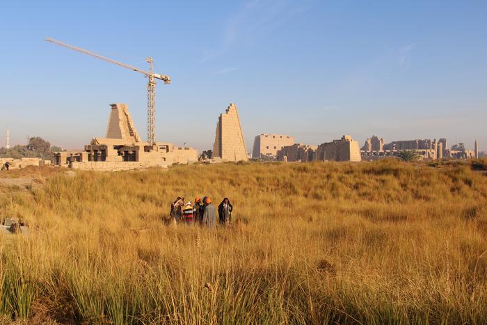
An international team of geoarchaeologists, led by scholars from Uppsala University, has produced the most comprehensive survey to date of the Karnak Temple complex in Egypt, one of the ancient world’s most magnificent and extensive temple sites. Located in modern-day Luxor, this UNESCO World Heritage site harbors layers of history extending back approximately 4000 years. The team’s recently published findings, appearing in the journal Antiquity, unravel the intimate relationship between the temple’s physical foundation, its surrounding riverine landscape, and the evolving myths and beliefs that shaped its significance over millennia.
Careful analysis of sediment cores taken from within and around the temple precinct reveals a dynamic and transformative history of the site’s geography. Before approximately 2520 BCE, the area that would later hold the temple was unsuitable for human settlement, as it was frequently inundated by fast-flowing waters from the Nile River. Geological and archaeological data, including ceramic fragments dated between roughly 2305 and 1980 BCE, point to the earliest human activity at Karnak emerging during the Old Kingdom period. This evidence fundamentally shifts prior assumptions, suggesting that the landscape underwent a critical transformation that enabled the establishment of permanent sacred architecture.
The formation of the temple’s foundation is intimately tied to geomorphic evolution, where ancient Nile river channels carved the region, isolating a high-ground terrace on what effectively became an island between east and west watercourses. This elevated terrain offered a stable base for the initial construction of Karnak’s monumental religious structures. Over time, the shifting courses of the Nile’s channels expanded the temple footprint, as sediment deposition and human engineering altered waterways. Notably, the team discovered that an eastern river channel, previously speculative in archaeological literature, was both more prominent and enduring than its western counterpart, a finding that reshapes understanding of the ancient landscape.
The hydrological evidence suggests that the eastern channel remained active well into the Roman era, only becoming a minor watercourse much later. The ancient Egyptians themselves appear to have manipulated this landscape feature intentionally. Archaeological indications show that desert sands were deliberately dumped into the silting eastern channel, demonstrating an early form of landscape engineering aimed at expanding sacred precincts. This manipulation highlights the sophistication of ancient Egyptian responses to their environment, blending natural forces with cultural aspirations.
Beyond the practical and environmental context, these geomorphological insights resonate profoundly with the cosmological and mythological narratives held by the ancient Egyptians. The discovery of a high island encircled by waters aligns strikingly with creation myths from the Old Kingdom, which describe the world’s origin as a primeval mound emerging from a chaotic watery expanse called Nun. Texts from this period depict a creator god manifesting as this island of emergent land—a symbol of order arising from chaos. The Karnak site, situated on such a natural formation, may have been perceived as the terrestrial embodiment of this sacred cosmological motif.
The research team, led by Dr. Ben Pennington of the University of Southampton, suggests that the localization of the temple at Karnak by Theban elites was likely a deliberate religious statement. They hypothesize that the selection of this site as the dwelling of Amun-Ra was not coincidental but reflected a deep alignment with theological beliefs, symbolizing the primeval mound rising from the primordial waters. Subsequent Middle Kingdom texts further develop this imagery, painting the temple’s emergence as a metaphor for the annual ebbing of floodwaters, a fundamental cyclic event that underpinned Egyptian cosmology and agricultural life.
This holistic understanding opens new perspectives on how the Karnak temple complex functioned not only as a religious and political center but as a living landscape intertwined with ancient Egyptians’ worldview. The intersection of environmental change, human adaptation, and mythological symbolism reveals Karnak as a microcosm of broader cultural and natural processes in the Nile Valley. These insights deepen appreciation for how ancient societies dynamically engaged with their environment to forge sacred spaces infused with profound meaning.
The work builds on prior multidisciplinary research articulated in a 2024 Nature Geoscience paper that mapped how climatic and environmental shifts sculpted the Nile Valley landscape over the last 11,500 years. The current study advances this trajectory by focusing explicitly on the geoarchaeological complexity of Karnak, integrating sedimentology, archaeology, and anthropological theory. Such integrative science exemplifies the potential to reconstruct ancient landscapes with a precision that illuminates the human story embedded within.
Methodologically, the study employed sediment coring at 61 sites, combined with detailed ceramic analysis to tightly constrain chronological frameworks. This approach enabled temporal reconstruction of landscape evolution while linking material culture to environmental contexts. The interplay between fluvial dynamics and anthropogenic activity underscores the nuanced and reciprocal relationship ancient societies held with their environment, transforming naturally evolving terrain into spaces of monumental human significance.
The revelations about Karnak’s foundation and development not only revise archaeological narratives but also contribute to broader discussions of sacred geography and landscape symbolism in ancient civilizations. They challenge prior models that underestimated the complexity of hydraulic and geomorphic influences on temple siting and evolution. The data-driven reinterpretation encourages a reconsideration of ritual architecture as embedded within and responsive to the environment, rather than isolated constructs.
This project was executed under the authorization of the Egypt Exploration Society in London and conducted with full permits from Egypt’s Ministry of Tourism and Antiquities. The responsible handling of archaeological sites alongside state permit compliance was integral to the research’s success, allowing critical on-site investigations in one of the world’s most revered historical landscapes.
The study’s findings pave the way for future research avenues, including refined hydrological modeling and deeper archaeological excavations that could further unravel how environmental management shaped not only Karnak but other Nile Valley sacred sites. By linking geological history with cultural evolution, the research underscores the enduring interplay between nature and human civilization, where landscapes both shape and reflect the spiritual and societal ideals of the people who inhabit them.
Subject of Research: Geoarchaeological investigation of the Karnak Temple complex’s foundation and landscape evolution.
Article Title: Conceptual origins and geomorphic evolution of the temple of Amun-Ra at Karnak (Luxor, Egypt)
News Publication Date: 6-Oct-2025
Web References: http://dx.doi.org/10.15184/aqy.2025.10185
References: Published in Antiquity; builds upon 2024 Nature Geoscience paper (doi.org/10.1038/s41561-024-01451-z)
Image Credits: Angus Graham/Uppsala University
Keywords: Karnak Temple, geoarchaeology, Nile Valley, ancient Egypt, geomorphology, creation myth, landscape evolution, sediment cores, river channels, Amun-Ra, primeval mound, archaeological survey
