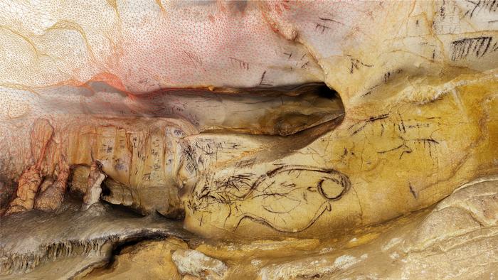
A groundbreaking advancement in archaeological documentation has emerged from a dedicated team of researchers at the University of Seville. Harnessing the power of cutting-edge technology, they have succeeded in capturing an intricate three-dimensional digital model of La Pileta Cave, located in Benaoján, Malaga. This cave, declared a National Monument since 1924, stands as an essential European benchmark in the domain of cave art due to its rich historical and cultural significance. La Pileta Cave preserves an extraordinary collection of graphic motifs that span an extensive period from the Upper Palaeolithic to the Bronze Age, offering an unparalleled glimpse into human artistic expression over millennia.
The digital model represents more than a technical feat—it captures thousands of images depicting animals, symbolic figures, and the silhouettes of early humans. Such motifs provide invaluable insight into prehistoric life and the cognitive development of our ancestors. Notably, La Pileta Cave houses an archaeological sequence exceeding 100,000 years in depth, reaffirming its unparalleled importance within the Iberian Peninsula’s cultural heritage. Among its most compelling artifacts is a lamp etched with pigmentation traces dating to the Gravettian period, widely regarded as one of the oldest illumination devices discovered in this region to date.
The researchers’ methodology unites two advanced technologies to achieve this unprecedented level of detail and accuracy. Firstly, they utilized a mobile LiDAR (Light Detection and Ranging) system integrated into a smartphone. This tool measures the distance between a laser emitter and surrounding surfaces via pulsed laser beams, enabling swift data acquisition even within confined or hard-to-navigate spaces of the cave. The smartphone LiDAR’s versatility is instrumental in capturing high-resolution textures and topographic details, notably in areas inaccessible to bulkier instrumentation.
Complementing this innovative mobile system, a terrestrial laser scanner was deployed to provide a comprehensive and highly precise spatial framework. While the mobile LiDAR excels in adaptability and capturing textures, the terrestrial scanner delivers long-range emission capabilities, creating a solid and reliable geometric foundation. Through the sophisticated fusion of these two complementary data sources, the team meticulously constructed a validated, geo-referenced 3D model of the cave environment. The margin of error was minimized by referencing established topographic control points, ensuring the scientific rigor and reliability of the model for subsequent analytical use.
This new 3D representation is more than an archival asset; it heralds transformative possibilities across archaeology, heritage management, and educational outreach. By preserving a digital twin of La Pileta Cave, scholars can revisit and analyze its rock art remotely, reducing the need for potentially damaging physical interactions with the site. The model enhances preventive conservation efforts by allowing detailed monitoring of environmental changes and identifying areas vulnerable to degradation. Furthermore, the high-definition imagery and spatial data underpin sophisticated rock art analyses, enabling researchers to decipher pigment compositions, layering techniques, and the spatial organization of motifs with greater precision than ever before.
The implications extend into the realm of immersive education and public engagement as well. Virtual reality (VR) and augmented reality (AR) applications derived from this precise 3D data offer unprecedented opportunities for museum exhibitions and remote explorations. Students and the general public can experience La Pileta Cave’s prehistoric art in vivid detail without compromising its physical integrity. This democratization of access to cultural heritage promises to inspire new generations of scholars and enthusiasts alike, fostering broader appreciation for humanity’s artistic legacy embedded within the cave’s walls.
This pioneering research, published in the Journal of Archaeological Science, represents a profound synthesis of archaeology and modern engineering. It testifies to the potential of embedded consumer technologies like smartphone LiDAR sensors to revolutionize archaeological practice, making advanced spatial documentation more accessible and cost-effective. The authors—Daniel Antón, Juan Mayoral, Mª Dolores Simón, Miguel Cortés, and Rubén Parrilla—bring together expertise from the University of Seville’s departments spanning Graphic Expression, Building Engineering, Prehistory, and Archaeology, along with collaboration from the University of Algarve in Portugal, underscoring the interdisciplinary nature of this project.
The research also sets an important precedent for future archaeological endeavors worldwide. It illustrates how mobile scanning technology can complement traditional terrestrial laser scanning, particularly in environments where access is restricted or where the fragility of the site necessitates minimal physical intrusion. This dual-technology approach balances efficiency, precision, and conservation, potentially redefining fieldwork protocols and data acquisition strategies in speleology and rock art documentation projects internationally.
Technically speaking, the fusion process involved advanced point cloud registration methods that ensured seamless integration of data gathered via disparate devices. The researchers addressed challenges related to variable lighting conditions, surface reflectivity, and geometric complexity inherent to natural cave surfaces. Their workflow not only preserved fidelity in capturing macroscopic spatial relationships but also facilitated the extraction of micro-textural details, critical for interpreting painting techniques and weathering processes affecting the motifs over thousands of years.
La Pileta Cave’s digitally immortalized form securely preserves a cultural heritage site that faces threats from natural erosion, human-induced wear, and climatic fluctuations. This innovative 3D model is an indispensable tool for heritage custodians, providing a baseline dataset for monitoring changes over time and informing targeted conservation interventions. Its availability also encourages collaborative research, inviting scholars globally to engage with the site’s data remotely, thereby expanding international archaeological discourse and comparative analyses.
In summary, the creation of a high-fidelity, smartphone LiDAR-enhanced 3D model of La Pileta Cave exemplifies the transformative impact of integrating emerging technologies into archaeological research. It enhances interpretative capabilities, supports sustainable site management, and broadens accessibility to previously remote and fragile historical locales. As smartphone LiDAR technology continues to advance, its role in cultural heritage documentation is poised to grow, fostering a new era where digital preservation and immersive learning converge to honor and perpetuate our shared human history.
Subject of Research: Archaeological and speleological research using smartphone LiDAR technology to create detailed 3D models of La Pileta Cave’s prehistoric art.
Article Title: Built-in smartphone LiDAR for archaeological and speleological research
News Publication Date: 7-Aug-2025
Web References: https://dx.doi.org/10.1016/j.jas.2025.106330
Image Credits: University of Seville
Keywords: Archaeological sites, Applied optics, Applied sciences and engineering
