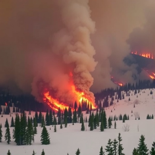
In May 2025, an unprecedented wildfire catastrophe engulfed vast tracts of Manitoba’s boreal forests, burning through approximately 8,667 square kilometers of land and causing widespread destruction. This disaster not only resulted in tragic loss of life and displacement of nearly a thousand residents but also raised pressing questions concerning the underlying environmental and climatic conditions that rendered the landscape so vulnerable. A groundbreaking study recently published in the journal Earth meticulously unpacks the complex web of factors that culminated in such devastating wildfire activity, revealing how a confluence of atypical weather patterns and stressed vegetation synergized to magnify fire risk beyond conventional expectations.
At the heart of this investigation lies the collaborative work led by Hossein Bonakdari, an Associate Professor at the University of Ottawa’s Faculty of Engineering, who utilized state-of-the-art satellite imaging alongside advanced climatic and vegetative data analysis. Their research delves into the intricacies of environmental anomalies—particularly deviations in snowpack, soil moisture, and vegetation indices—that preconditioned Manitoba’s landscapes for extreme wildfire susceptibility. By decoding these multiple dimensions, the team elucidated how moderate but simultaneous stresses on the ecosystem’s health created a perilous environment primed for rapid fire ignition and spread.
The early weeks of May 2025 were marked by atypical climatic trends—unseasonably warm temperatures coupled with prolonged drought conditions—that directly impacted the terrestrial and biosphere components of the region. Satellite data revealed a substantial reduction in snowpack accumulation during the preceding winter and spring months, leading to diminished meltwater contributions essential for soil saturation. This deficit in soil moisture critically stressed vegetative cover, as evidenced by declining greenness indices, signaling weakened plant vitality and increased flammability. These compounded factors, acting in concert rather than isolation, generated a landscape vulnerable at scales beyond what singular variables might predict.
Crucially, the study highlights the concept of synergistic interaction among climate anomalies, where moderate individual anomalies, when concurrent, amplify fire risk exponentially. This phenomenon challenges traditional wildfire risk modeling approaches that often evaluate indicators in isolation. The cumulative effect of reduced precipitation, extreme heat, and vegetative stress created a feedback loop potentiating rapid fire propagation, as observed in the 2025 Manitoba wildfires. Such insights underscore the imperative need to redesign monitoring frameworks by integrating multidimensional environmental data streams to foster more robust early warning systems.
One of the study’s pivotal achievements is the leveraging of satellite-based remote sensing technology to track these environmental variables with unprecedented temporal and spatial resolution. By quantifying snowpack dynamics, soil moisture profiles, and vegetative health indices in near-real-time, researchers were able to reconstruct the pre-fire conditions that predisposed the landscape to catastrophe. This method not only enhances understanding of fire ignition patterns but also provides actionable data to fire management agencies aiming to anticipate and mitigate future outbreaks.
The altered wildfire behavior observed in Manitoba is indicative of broader shifts in boreal ecosystem responses to climate change. The rapid advancement of fire fronts, starkly contrasting with historical fire dynamics, signals that rising global temperatures and changing precipitation regimes are reshaping fundamental ecological processes. Such transformations pose significant challenges for ecosystem resilience, wildlife habitat conservation, and the socio-economic frameworks of forest-dependent communities.
Professor Bonakdari emphasizes that these findings should serve as a clarion call for improving wildfire preparedness strategies, particularly in northern latitudes where boreal forests dominate. The traditional reactive approaches to wildfire management must evolve into proactive, data-informed planning that incorporates nuanced understandings of synergistic environmental stressors. Monitoring efforts integrating satellite data with ground-based meteorological and ecological observations will be critical in forecasting high-risk scenarios with greater accuracy.
Moreover, the study raises vital considerations regarding the scalability of wildfire risk assessment tools worldwide. As many global regions encounter similar climate-induced stresses, the methodologies presented here offer a blueprint for other jurisdictions seeking to enhance their fire monitoring capabilities. The adaptability of imaging analysis makes it an invaluable asset in decoding complex interactions between climate variables and biosphere health across diverse landscapes.
In addition to emphasizing technological innovation, the research draws attention to policy implications inherent in managing wildfire risk amidst climate uncertainty. Decision-makers must balance resource allocation between immediate firefighting needs and long-term ecosystem management strategies that address underlying vulnerabilities—such as forest health restoration and landscape hydrology enhancement. An integrated policy approach that recognizes the multifaceted nature of fire risk drivers could significantly improve resilience against increasingly frequent and intense fire seasons.
The tragic events in Manitoba reaffirm the dire consequences of climate change’s intersecting impacts on natural systems. They expose the limitations of historical risk paradigms and the necessity to embrace interdisciplinary, forward-looking scientific inquiry. This study acts as both a diagnostic tool and a strategic guide, illuminating pathways towards more effective stewardship of boreal forests in an era where environmental anomalies are no longer outliers but defining conditions.
Ultimately, the insights garnered from the May 2025 wildfires compel a recalibration of how we perceive, anticipate, and manage wildfire threats. While individual factors such as temperature extremes or drought are well-established risk elements, their simultaneous manifestation cannot be underestimated. As Professor Bonakdari succinctly puts it, “the convergence of multiple environmental anomalies creates fire risk landscapes that traditional models might fail to recognize,” signaling an urgent call for integrating complex data layers in wildfire science.
As global climatic patterns continue to evolve, the necessity to harness comprehensive satellite-derived monitoring and integrate ecological indices becomes paramount. Future wildfire preparedness will increasingly depend on the synergy between cutting-edge technology and interdisciplinary scientific collaboration. This study not only advances academic understanding but also lays the groundwork for actionable interventions, emphasizing that in the face of nature’s escalating challenges, adaptability and innovation remain our strongest defenses.
Subject of Research: Not applicable
Article Title: A Lens on Fire Risk Drivers: The Role of Climate and Vegetation Index Anomalies in the May 2025 Manitoba Wildfires
News Publication Date: 28-Jul-2025
Web References: https://www.mdpi.com/2673-4834/6/3/88
References: DOI: 10.3390/earth6030088
Image Credits: The University of Ottawa
Keywords: Abrupt climate change
