As Global South cities undergo rapid urbanization, the fabric of their pedestrian environments rarely aligns with the neat and meticulously planned infrastructures associated with many Global North metropolitan areas. Unlike cities such as New York or London, where pedestrian pathways are often well-regulated, coherent, and protected from vehicular interference, the lived reality in cities like Phnom Penh showcases a complex, informal, and fragmented walking experience. It is within this context that Singapore University of Technology and Design’s Assistant Professor Samuel Chng and his team undertook a pioneering study to analyze pedestrian route choices in Phnom Penh, Cambodia—a city facing unique urban and climatic challenges that confound traditional walkability assumptions.
Phnom Penh’s pedestrian landscape is dynamically shaped by a mosaic of uneven infrastructure quality, tropical heat stress, and prevalent informal uses of public space such as motorcycle parking along sidewalks and street vendors occupying footpaths. These elements not only disrupt pedestrian flow but also redefine what it means for a route to be “walkable.” Asst Prof Chng’s research, published in the journal Travel Behaviour and Society, meticulously investigates these multifaceted issues through the lens of revealed preferences, harnessing vast volumes of anonymized GPS data capturing over six thousand walking trips. By coupling this rich movement data with street-level imagery and point-of-interest databases, the research presents a nuanced model delineating how physical attributes of urban design interact with human behaviors to shape actual pedestrian navigation decisions.
Central to the analysis is the application of a Path Size Logit model, a sophisticated route choice modeling framework that accounts for the complexity and overlap of pedestrian paths beyond mere distance measurements. The team’s study area consisted of three distinctive districts within Phnom Penh: the highly urbanized Central Business District (CBD), the recreational zone clustered around the Independence Monument, and the vibrant commercial sector near the Russian Market. To further enrich the analysis, pedestrian trips were temporally segmented into morning, midday, and evening periods in order to capture the variation in route choice behavior depending on environmental conditions and daily rhythms.
Findings from this comprehensive survey reveal that pedestrian route selection transcends the simplistic heuristic of shortest path preference traditionally assumed in urban models. Instead, individuals engage in a deliberate balancing act among efficiency, street vitality, and perceived comfort. Shorter and less convoluted routes remained dominant choices, with the data revealing that each additional turn on a short walking trip was psychologically equivalent to adding approximately 40 meters in distance. Interestingly, this perception attenuates for longer journeys beyond 1.3 kilometers. The presence of amenities along the route plays a counterbalancing role by effectively shortening perceived distances by around 10 meters per additional service point, underscoring how environmental richness impacts walking decisions.
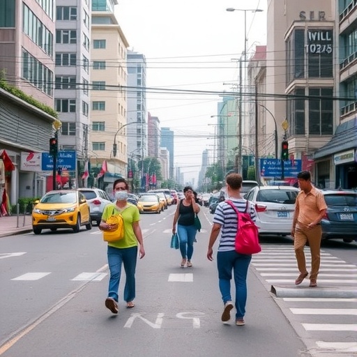
Perhaps the most striking discovery emerged from analyzing traffic preferences. Contrary to well-established norms in many Global North cities, Phnom Penh’s pedestrians displayed a marked preference for walking alongside busy roads while avoiding crowded footpaths. This counterintuitive behavior fundamentally challenges decades of assumptions tied to pedestrian comfort and safety, which often emphasize avoidance of vehicular activity. Asst Prof Chng elucidates that in Phnom Penh, high-traffic roads often offer superior regulatory frameworks, clearer spatial organization, and reduced informal obstructions, making them more legible and easier to navigate relative to cluttered side streets and footpaths frequently encumbered by street vendors and parked motorcycles.
Temporal variation further nuances route choice patterns. Morning walkers showed significant sensitivity to greenery along their paths, hinting at the importance of early-day environmental quality and possibly microclimatic shading. Conversely, midday pedestrians prioritized direct routes, likely to minimize exposure to harsh tropical heat. Evening walkers gravitated toward amenity-rich, active streets that presumably offer better lighting and enhanced perceptions of safety during hours of darkness. The study also highlights the inadequacy of sporadic vegetation in Phnom Penh to provide meaningful thermal refuge, pointing toward a critical need for urban design interventions that amplify the functional value of greenery in tropical urban contexts.
Moving beyond behavioral insights, the research translates its findings into perceptual accessibility maps that reveal a sobering reality: the actual walkable catchments perceived by residents are considerably smaller than conventional, distance-based service areas. In Phnom Penh’s CBD, the area that pedestrians consider comfortably reachable on foot shrinks to just 37.7% of the objective 800-meter radius. The commercial district exhibits better accessibility at nearly 64%, while the recreational area lies between these extremes. These gaps between perceived and objective accessibility highlight critical shortcomings in traditional urban planning models that might overestimate pedestrian reachability and, consequently, the inclusivity and connectivity of urban spaces.
Methodologically, the study confronts the inherent limitations posed by using anonymized GPS data, which lacks socio-demographic granularity such as age, gender, or income characteristics, and is constrained to observations within a single dry season month. Nonetheless, the integration of mobile GPS tracking with environmental and amenities data exemplifies a cutting-edge, data-driven approach to understanding pedestrian behaviors in complex urban environments. Future research directions point toward expanding this framework to incorporate temporal variability across seasons and enriching data with socio-demographic attributes through advanced data fusion techniques, potentially enabling more targeted urban design interventions.
The implications of Asst Prof Chng’s work are profound. It suggests that improving walkability in rapidly growing cities of the Global South requires a reorientation of focus away from purely distance-based factors or the imposition of infrastructure models derived from vastly different urban contexts. Instead, planners should prioritize walkability as an experience defined by clarity, predictability, and unobstructed, legible pathways. Practical urban interventions that reduce physical and perceptual friction—such as clearing informal encroachments, enhancing visibility, and creating direct pedestrian routes—are essential precursors to layering in features like greenery or amenities that improve comfort and enjoyment.
Summarizing the core findings, it becomes clear that walking is not merely a matter of urban form geometry; it is inherently shaped by the intertwined dimensions of human perception, physical comfort, and socio-spatial order. By illuminating these complexities in Phnom Penh—a city emblematic of many fast-urbanizing Global South centers—this research charts a path toward more contextually grounded and empirically informed pedestrian urbanism. As cities globally seek sustainable ways to reduce car dependency and promote active transportation, such culturally and climatically sensitive studies provide indispensable insights into what truly makes walking in cities attractive and accessible.
Ultimately, the research underscores the pressing necessity for urban policy and planning in developing cities to embrace a more sophisticated understanding of pedestrian behavior—one that transcends simplistic metrics and embraces the nuanced, lived realities on the ground. Ensuring walking networks are straightforward, legible, and free from obstruction before introducing additional amenities is the key actionable insight from this study. If overlooked, cities risk perpetuating environments that systematically disadvantage pedestrians despite appearances of infrastructural adequacy, thereby undermining equity and sustainability objectives critical to urban futures.
Subject of Research: Pedestrian route choice behavior and walkability in developing urban environments of the Global South
Article Title: Walking the preferred path: exploring spatial-temporal variation in pedestrian route choice through revealed preferences in a developing city
Web References: http://dx.doi.org/10.1016/j.tbs.2026.101278
Image Credits: Singapore University of Technology and Design (SUTD)
Keywords: urban walkability, pedestrian behavior, Global South cities, Phnom Penh, route choice modeling, Path Size Logit model, urban planning, tropical cities, mobile GPS data, urban informality, pedestrian comfort, accessibility mapping
