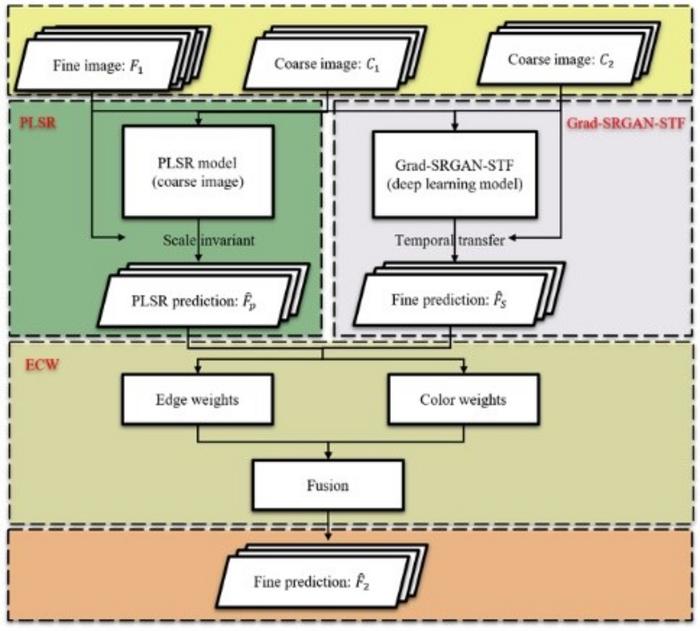
Researchers have introduced StarFusion, a cutting-edge spatiotemporal fusion method that significantly improves the temporal resolution and fusion accuracy of high-resolution satellite imagery in agriculture. By fusing data from China’s Gaofen-1 and Europe’s Sentinel-2 satellites, StarFusion addresses the common problem of infrequent imaging due to long revisit periods and cloud cover interference from high-resolution satellites, which often hinders the effectiveness of high-resolution remote sensing in dynamic agricultural environments. By integrating deep learning with traditional regression models, the method enhances both spatial detail and temporal resolution, making it an invaluable tool for more effective crop monitoring and management.

Credit: Journal of Remote Sensing
Researchers have introduced StarFusion, a cutting-edge spatiotemporal fusion method that significantly improves the temporal resolution and fusion accuracy of high-resolution satellite imagery in agriculture. By fusing data from China’s Gaofen-1 and Europe’s Sentinel-2 satellites, StarFusion addresses the common problem of infrequent imaging due to long revisit periods and cloud cover interference from high-resolution satellites, which often hinders the effectiveness of high-resolution remote sensing in dynamic agricultural environments. By integrating deep learning with traditional regression models, the method enhances both spatial detail and temporal resolution, making it an invaluable tool for more effective crop monitoring and management.
Remote sensing plays a vital role in monitoring agricultural landscapes, yet current satellite sensors often struggle with the trade-off between spatial and temporal resolution. High spatial resolution images, while detailed, are often limited by infrequent captures and cloud interference, reducing their utility in rapidly changing environments. Conversely, images with better temporal resolution lack the necessary spatial detail for precise analysis. These challenges underscore the need for advanced fusion methods that can better serve agricultural applications.
A team from the State Key Laboratory of Remote Sensing Science at Beijing Normal University, in collaboration with other institutions, has developed StarFusion, a new spatiotemporal fusion method. Published (DOI: 10.34133/remotesensing.0159) on July 22, 2024, in the Journal of Remote Sensing, the study combines deep learning and traditional regression techniques to address the limitations of current fusion methods. StarFusion effectively merges high-resolution Gaofen-1 data with medium-resolution Sentinel-2 data, resulting in significantly enhanced imagery for agricultural monitoring.
StarFusion represents an innovative approach to spatiotemporal image fusion, blending the strengths of deep learning and traditional regression models. By integrating a super-resolution generative adversarial network (SRGAN) with a partial least squares regression (PLSR) model, StarFusion achieves high fusion accuracy while preserving fine spatial details. The method effectively manages challenges like spatial heterogeneity and limited cloud-free image availability, making it highly practical for real-world agricultural applications. Extensive testing across various agricultural sites has shown that StarFusion outperforms existing techniques, particularly in maintaining spatial detail and enhancing temporal resolution. Its capability to function with minimal cloud-free data sets it apart, providing a reliable solution for crop monitoring in regions plagued by frequent cloud cover.
“StarFusion represents an valuable attempt in remote sensing technology for agriculture,” said Professor Jin Chen, the study’s lead author. “Its ability to generate high-quality images with improved temporal resolution will greatly enhance precision agriculture and environmental monitoring.”
StarFusion offers significant advantages for digital agriculture, providing high-resolution imagery essential for detailed crop monitoring, yield prediction, and disaster assessment. Its ability to produce accurate images despite cloud cover and limited data availability makes it particularly valuable for agricultural management in regions with challenging weather conditions. As this technology evolves, StarFusion is expected to play a crucial role in advancing agricultural productivity and sustainability.
###
References
DOI
Original Source URL
Funding information
This study was supported by High-Resolution Earth Observation System (09-Y30F01-9001-20/22).
About Journal of Remote Sensing
The Journal of Remote Sensing, an online-only Open Access journal published in association with AIR-CAS, promotes the theory, science, and technology of remote sensing, as well as interdisciplinary research within earth and information science.
Journal
Journal of Remote Sensing
Subject of Research
Not applicable
Article Title
A Hybrid Spatiotemporal Fusion Method for High Spatial Resolution Imagery: Fusion of Gaofen-1 and Sentinel-2 over Agricultural Landscapes
Article Publication Date
22-Jul-2024
COI Statement
The authors declare that they have no competing interests.


