

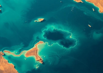
AI Maps the Seafloor of Egypt’s Largest Lagoon From Space With Centimeter Precision
Egyptian researchers used Landsat 8 imagery and machine learning to map the bathymetry of Manzala Lagoon with centimeter-level accuracy, identifying ...
Egyptian researchers used Landsat 8 imagery and machine learning to map the bathymetry of Manzala Lagoon with centimeter-level accuracy, identifying ...

A new 30-meter-resolution annual dataset shows China's forest trees rose from about 106 billion to 182 billion between 1985 and ...
A 2020 glacial lake outburst flood in southeastern Tibet abruptly severed Jinwu Glacier's contact with its lake, slowing the ice ...
A new GIS-based study maps groundwater potential across Brazil's semi-arid Grande River Basin, revealing that the most favorable recharge zones ...
A new study in Argentina's Monte desert shows that whether pixel-based or object-based satellite classification works best for detecting open ...
A systematic review of 190 studies finds that integrated geospatial, meteorological, hydrological and AI-based approaches are transforming flood risk assessment, ...
A decade of satellite radar data reveals that land subsidence is widespread across 465 major cities worldwide, with hotspots in ...
An integrated satellite, GIS, and multi-criteria analysis has mapped groundwater potential across Bangladesh's largest inland wetland, revealing that only one ...
Egyptian researchers have built a hybrid Vision Transformer and CNN framework with spectral band selection that outperforms few-shot learning methods ...
A Random Forest model built on satellite fire records shows that nearly 30 percent of forest in Nepal's mountainous Rasuwa ...

Embark on a thrilling journey of discovery with Scienmag.com—your ultimate source for cutting-edge breakthroughs. Immerse yourself in a world where curiosity knows no limits and tomorrow’s possibilities become today’s reality!