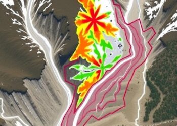
High-Accuracy Landslide Mapping in East Sikkim
In a groundbreaking advancement for the geosciences community, researchers Golder and Bhandari have unveiled a novel and high-precision framework for ...
In a groundbreaking advancement for the geosciences community, researchers Golder and Bhandari have unveiled a novel and high-precision framework for ...

In a groundbreaking study that could reshape the landscape of environmental remediation, researchers Lv, Zhang, and Chai have unveiled critical ...
In an era where urban expansion continues unabated and industrial activities surge, the quest to monitor and mitigate environmental pollution ...
A groundbreaking numerical study has emerged from the realm of geothermal energy research, shedding light on the immense potential of ...
In a groundbreaking study poised to redefine our understanding of groundwater contamination, scientists have uncovered alarming levels of uranium in ...
In August 2018, the eastern region of Guangdong, China, experienced a significant surge in rainfall-induced landslides, prompting a thorough scientific ...
In a groundbreaking study published in Environmental Earth Sciences, researchers Lv, Chen, Cao, and colleagues have unveiled the profound impact ...
In a groundbreaking study published in Environmental Earth Sciences, researchers have unveiled new insights into the origins and distributions of ...
In a groundbreaking study published in Environmental Earth Sciences, researchers Pereira, Monterrubio, and Bloise delve deep into the complex geological ...
The Intricate Dance of Soil Properties: Mapping Erodibility in Headwater Catchments Soil erosion is a pervasive and complex environmental challenge ...
Embark on a thrilling journey of discovery with Scienmag.com—your ultimate source for cutting-edge breakthroughs. Immerse yourself in a world where curiosity knows no limits and tomorrow’s possibilities become today’s reality!