Scientists have made a groundbreaking contribution to our understanding of the atmospheric disturbances caused by seismic activities through the use of Global Navigation Satellite System (GNSS) receivers. The recent study led by researchers from Nagoya University has produced the first-ever three-dimensional images that detail the atmospheric disturbances triggered by the 2024 Noto Peninsula Earthquake, which struck Ishikawa Prefecture, Japan. This research highlights the intricate connection between geological phenomena and atmospheric behavior, especially how earthquakes can generate sound waves that propagate through the atmosphere and create disruptions in the upper layers known as the ionosphere.
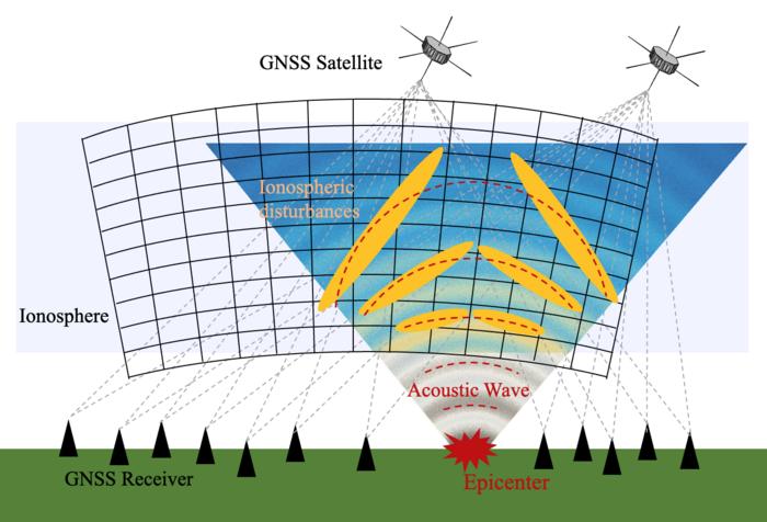
The fundamental methodology employed in this investigation involved utilizing Japan’s extensive network of over 4,500 GNSS receivers, which is recognized as one of the densest GNSS networks globally. These receivers possess the capability not only to track precise locations but also to detect minute changes in the ionosphere, a crucial layer of earth’s atmosphere that lies between 60 to 1,000 kilometers above the surface. By employing these GNSS units, the research team sought to unravel the details surrounding the electron density changes in the ionosphere that were instigated by the earthquake.
When an earthquake occurs, it generates sound waves that travel upward, creating a complex pattern of disturbances in the atmosphere, much like ripples on the surface of a pond when a stone is tossed into it. As these sound waves ascend, they interact with the electrically charged particles present in the ionosphere. This interaction causes delays in the satellite signals passing through, which can then be analyzed to deduce information about the number of electrons along the signal’s path. This electron mapping is crucial, as it allows scientists to monitor and scrutinize the varying conditions of the ionosphere.
Following the Noto Peninsula Earthquake, which registered a magnitude of 7.5 on January 1, 2024, the research team meticulously collected data regarding the number of electrons influenced by the sound waves. This data collection, pursued about ten minutes post-quake, was pivotal in constructing a time series that depicted how electron density fluctuated over time as the sound waves traversed through the ionosphere.
One significant aspect of this research was the observation of a tilted sound wave pattern emerging south of the earthquake’s epicenter. As time progressed, this pattern transitioned from a tilt to a more vertical alignment, shedding light on the dynamic nature of sound wave propagation in the atmosphere following seismic activities. Traditionally, scientific models have operated under the assumption that earthquakes produce sound waves emanating solely from a single point at the earthquake’s focal area. This conventional view failed to account for the complexities observed in the wave patterns detected by the GNSS receivers.
In a paradigm shift, the researchers incorporated data from various sources along the fault line in their analysis. This new approach recognized that different segments of the fault could generate sound waves at staggered intervals, specifically around 30 seconds after the initial rupture. Such a realization enabled a more nuanced understanding of the atmospheric disturbances, showcasing that earthquakes produce waves from multiple locations, rather than a centralized point. This multifaceted wave depiction aligns with the uneven and complex wave patterns observed in the GNSS data.
The implications of understanding these atmospheric disturbances extend beyond mere academic interest. In practice, disturbances in the ionosphere can significantly interfere with satellite communications and navigation accuracy. As our world becomes increasingly dependent on satellite technology for daily functionalities and disaster management systems, the ability to predict and better comprehend these disturbances becomes crucial. An improved understanding of atmospheric response during seismic events could lead to advancements in protecting sensitive tech infrastructures from potential disruptions during and after earthquakes.
Dr. Weizheng Fu, the principal investigator, emphasizes that this research opens doors not only for further exploration of earthquake-related phenomena but also for investigating other natural phenomena such as volcanic eruptions and severe weather events. The capability to visualize and model the ionospheric responses could lead to improvements in early warning systems designed to mitigate the impacts of such natural events on technology-dependent populations.
The ongoing exploration into these atmospheric disturbances carries profound potential in fortifying communication systems and enhancing navigation technologies, particularly in seismic-prone regions. As the team continues to refine their methodologies and model complexities, they aim to extend their findings to encompass a broader range of natural disturbances, ultimately improving our readiness and resilience in the face of natural disasters.
In conclusion, the marriage of geosciences and atmospheric studies embodied in the findings from the 2024 Noto Peninsula Earthquake exemplifies the innovative directions in which science is proceeding. The research not only sheds light on the intricate mechanics of earthquake-generated sound waves but also highlights the broader implications for technology and communication in the modern era, showcasing the need for continuous research and development in understanding our planet’s dynamic systems.
Subject of Research: Atmospheric disturbances caused by the 2024 Noto Peninsula Earthquake
Article Title: Unveiling the vertical ionospheric responses following the 2024 Noto Peninsula Earthquake with an ultra‑dense GNSS network
News Publication Date: 29-May-2025
Web References: Earth, Planets and Space
References: 10.1186/s40623-025-02211-y
Image Credits: Weizheng Fu, Nagoya University
Keywords
Earthquake, ionosphere, GNSS, atmospheric disturbances, seismic waves
