Groundwater, the hidden lifeline beneath the Earth’s surface, is a critical resource sustaining billions globally. As water scarcity becomes an increasingly daunting challenge, innovative methods to identify and manage groundwater reserves have surged to the forefront of environmental science. A groundbreaking study recently published in Environmental Earth Sciences has unveiled a cutting-edge approach that synergizes remote sensing technology with Geographic Information System (GIS)-based Analytical Hierarchy Process (AHP) modeling to map groundwater potential with unprecedented accuracy.
The study, led by researchers Rahim, Yin, Ullah, and their colleagues, represents a paradigm shift in hydrogeological assessments. Traditional methods of groundwater exploration often involve laborious fieldwork, extensive drilling, and disparate data collection, which can be costly and time-consuming. This integration of remote sensing and AHP within a GIS framework offers a high-tech alternative that leverages satellite data to derive essential geological, hydrological, and morphological parameters critical for groundwater assessment.
Remote sensing, a technology that captures data from satellites or aerial sensors without direct contact, allows scientists to analyze vast landscapes in real-time. These observations provide comprehensive insights into land surface features, vegetation cover, soil moisture, and geomorphological structures. The study utilizes this technology’s strengths to capture multifaceted environmental variables that influence groundwater recharge and storage, including lithology, slope, land use, drainage density, and rainfall patterns.
Complementing remote sensing is the use of GIS, a spatial analysis tool that organizes, analyzes, and visualizes geographic data. GIS enables the overlay of various environmental layers extracted from remote sensing outputs. In this research, GIS forms the backbone for data integration, facilitating a composite view of groundwater prospects by combining thematic maps derived from satellite images and existing geological surveys.
At the crux of this integration lies the Analytical Hierarchy Process (AHP), an advanced decision-making tool rooted in multi-criteria evaluation. AHP systematically assigns weights to each groundwater-influencing factor based on their relative importance. This allows for a quantitative prioritization in the model, reflecting real-world hydrogeological processes rather than a simplistic equal weighting approach. The study meticulously adjusted these weights, informed by expert judgment and empirical data, to construct a robust groundwater potential map.
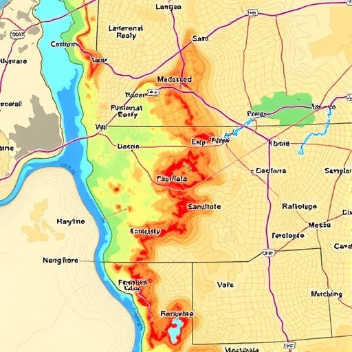
The researchers applied their innovative approach over a defined study area characterized by diverse terrain and complex hydrological conditions. By combining normalized indices of lithology type, slope steepness, drainage density, land use/land cover, and rainfall, the resulting groundwater potential map demarcated zones ranging from very low to very high groundwater availability. This gradient provides an invaluable tool for policymakers and water resource managers to target sustainable extraction and conservation efforts.
Significantly, the model’s efficiency was validated against existing well data, confirming a remarkable concordance between predicted high-potential zones and actual groundwater presence. Such validation not only confirms the credibility of the integrated remote sensing-GIS-AHP model but also underscores its practical utility for groundwater exploration, especially in regions lacking comprehensive hydrogeological surveys.
The implications of this research extend far beyond academic circles. Water-stressed regions around the world can harness this methodology to rapidly identify groundwater reserves with minimal environmental disturbance and reduced operational costs. This capability could revolutionize water resource planning, particularly in remote or arid areas where data paucity and infrastructural challenges impede conventional groundwater exploration.
Moreover, the inclusion of various physiographic and climatic parameters within the model ensures adaptability across diverse geographical settings. Researchers emphasize that the flexibility to recalibrate AHP weights allows the approach to be tailored to specific regional hydrogeological contexts, enabling broad applicability and enhancing global water security strategies.
Perhaps one of the most compelling prospects is the potential to integrate this method with real-time satellite data, ushering in dynamic groundwater monitoring systems. Such developments could track temporal changes in groundwater recharge related to climatic variability or anthropogenic impacts, furnishing water managers with timely and actionable insights.
This innovative synthesis of remote sensing, GIS, and AHP epitomizes interdisciplinary synergy that leverages technological advancements to tackle age-old water resource challenges. The visual clarity and precision of the groundwater potential maps produced herald a new era in hydrogeology, characterized by data-driven decision-making and sustainable resource management.
Intriguingly, the research team envisions future enhancements incorporating machine learning algorithms to further refine groundwater potential predictions by assimilating more complex spatial data patterns. This evolution could elevate the approach from deterministic models to more predictive analytics, bolstering groundwater management in an era of accelerating climate change.
The study also highlights the socio-economic benefits of such technology, advocating that communities dependent on groundwater can avoid costly drilling sprees that often yield disappointing or unsustainable results. By focusing investments in zones identified as high potential, water supply infrastructure can be developed efficiently, minimizing ecological footprints.
Technical details underpinning the methodology underscore its meticulousness. Satellite datasets from multispectral sensors were subjected to rigorous preprocessing for atmospheric corrections and geometric accuracy. Subsequent classification of land use and geological features employed supervised algorithms validated through ground truth data. Overlay analysis within GIS was executed with spatial resolution optimized to capture micro-scale variations that influence localized groundwater behavior.
In operational terms, the AHP matrix involved pairwise comparisons of seven influential parameters, systematically graded to establish relative priority scales. The consistency ratio was meticulously calculated to ensure the robustness of weighting decisions, further reinforcing scientific rigor.
The marriage of remote sensing’s expansive observational power with GIS’s analytical capabilities, framed through AHP’s decision support system, constitutes a formidable toolkit propelling groundwater science to new frontiers. As water security garners escalating global attention, the methodologies showcased in this study offer well-timed and potent solutions poised to impact policies and practices worldwide.
In conclusion, the integration of remote sensing and GIS-based Analytical Hierarchy Process detailed in this transformative research presents a scalable, evidence-based approach for groundwater potential mapping. By harnessing satellite imagery, spatial analysis, and multi-criteria evaluation, this technique promises to enhance water resource sustainability amid mounting environmental stresses. As the water crisis deepens globally, such innovative, tech-driven methodologies illuminate a path toward responsible stewardship of one of Earth’s most precious yet invisible resources.
Subject of Research:
Integration of remote sensing and GIS-based Analytical Hierarchy Process for mapping groundwater potential.
Article Title:
Integrated remote sensing and GIS-Based analytical hierarchy process for groundwater potential mapping.
Article References:
Rahim, O.A., Yin, H., Ullah, S. et al. Integrated remote sensing and GIS-Based analytical hierarchy process for groundwater potential mapping. Environ Earth Sci 84, 630 (2025). https://doi.org/10.1007/s12665-025-12605-6
Image Credits: AI Generated
