Groundwater resources are increasingly vital in addressing global water scarcity, food production, and climate resilience. A significant breakthrough in the field of hydrology has emerged from a recent study published in Communications Earth & Environment, where researchers unveiled high-resolution estimates of water table depth across the United States. This research not only sheds light on the accessibility of groundwater but also emphasizes its potential impact on numerous sectors ranging from agriculture to urban development.
Researchers Ma, Condon, and Koch, et al., employed advanced modeling techniques to generate unprecedentedly detailed maps of groundwater levels, providing deeper insights into one of Earth’s most critical resources. By integrating remote sensing data with ground measurements, the team constructed a comprehensive dataset that pinpoints water table depths with remarkable resolution. This development comes at a crucial time when many regions face declining water resources due to prolonged periods of drought and over-extraction.
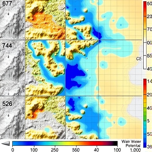
Water tables signify the top of the saturated zone of groundwater and directly influence soil moisture, agricultural yields, and ecological health. The innovative study demonstrates the critical relationship between land use patterns and groundwater accessibility, a relationship previously obscured by coarse data resolution. High-resolution mapping allows stakeholders to make more informed decisions regarding sustainable water management practices, vital in the face of increasing competition for water resources among various sectors.
The employed methods in this study capitalize on advancements in remote sensing technology, particularly satellite-based measurements. By utilizing these tools, researchers were able to minimize the uncertainties linked to traditional groundwater measurement methods. This groundbreaking work not only provides accurate data but also enhances our understanding of regional discrepancies in water table depths influenced by geology, land cover, and climatic factors.
One of the study’s significant findings reveals stark contrasts in groundwater accessibility across different regions. Areas heavily reliant on agriculture presented deeper water tables, often reflecting both historic over-extraction practices and changes in land use. These insights are invaluable for policymakers and farmers alike who are grappling with the dual pressures of providing adequate water for crops and maintaining sustainable practices to protect this precious resource.
Moreover, the implications of this research extend far beyond agricultural needs. Urban planners and water resource managers can leverage the dataset to develop strategies that adapt to shifting water levels. For instance, infrastructure projects that may impact groundwater systems can be evaluated more accurately to mitigate adverse effects on aquifer depletion. This research paves the way for enhanced collaboration among diverse stakeholders to foster sustainable water use.
The integration of machine learning algorithms served to refine the predictive capabilities of groundwater modeling. By processing vast amounts of data, the researchers could identify trends and potential vulnerabilities in groundwater resources. Harnessing such sophisticated technology illustrates how interdisciplinary approaches can yield substantial advancements in environmental science, particularly in understanding complex hydrological cycles.
In addition to its immediate local impact, this research contributes to a global discourse on water resource management. As climate change continues to alter precipitation patterns and increase the frequency of extreme weather events, understanding groundwater dynamics becomes increasingly crucial. The high-resolution data presented in this study can inform global modeling efforts aimed at predicting future water availability under various climate scenarios, ensuring preparations are made for potential disparities in global water distributions.
Refining water conservation strategies through the lens of this research can also enhance resilience to climate-related challenges. Adaptive management practices that incorporate real-time groundwater monitoring can be pivotal in maintaining water security. This approach reiterates the necessity for ongoing research dedicated to groundwater systems, as they play an essential role in sustaining ecosystems and human communities alike.
Importantly, the team acknowledges the limitations faced during their research, including the challenges of modeling in regions with limited historical data. Nonetheless, the robustness of their findings and the potential for future studies utilizing similar methodologies provide optimism for expanded understanding of groundwater systems worldwide. As further research and developments occur, this foundational work sets the stage for enhanced water security and management practices.
The high-resolution mapping of water table depths opens new avenues for further inquiry into supplementary factors impacting groundwater resources. For instance, climate adaptations that also scrutinize the interaction of land practices with hydrology could unveil additional layers of complexity and interdependence among ecological systems. Such integrative approaches speak to the interconnectedness of water resource management with broader atmospheric, geological, and environmental issues.
The revelations from this research underscore the urgent necessity to reassess existing water policies with an emphasis on sustainable management. Traditional methods that often overlook the granular dynamics of groundwater accessibility may lead to misconceptions or mismanagement of these resources. As these findings permeate through agricultural, urban, and environmental discussions, innovative water management practices can emerge, fostering a future where water security is more assured and resilient to climatic fluctuations.
The meticulous nature of the study reveals not only the complexity involved in groundwater analysis but also promotes a spirit of collaboration among scientists, government agencies, and stakeholders invested in water conservation initiatives. Continued investment in technology and research will prove essential as humanity navigates the myriad challenges associated with ensuring water for generations to come.
In conclusion, Ma, Condon, and Koch’s study marks a significant step forward in comprehensively understanding groundwater resources in the United States. By divulging previously inaccessible data, this research acts as a catalyst for informed decision-making and innovative practices across multiple sectors. As we confront the realities of climate change, resource scarcity, and population growth, the findings from this study will be integral to guiding the future of sustainable water management and groundwater conservation efforts.
Subject of Research: High-resolution mapping of groundwater accessibility in the United States
Article Title: High resolution US water table depth estimates reveal quantity of accessible groundwater
Article References:
Ma, Y., Condon, L.E., Koch, J. et al. High resolution US water table depth estimates reveal quantity of accessible groundwater.
Commun Earth Environ 7, 45 (2026). https://doi.org/10.1038/s43247-025-03094-3
Image Credits: AI Generated
DOI: https://doi.org/10.1038/s43247-025-03094-3
Keywords: Groundwater, Water Table Depth, Remote Sensing, Hydrology, Water Management, Climate Change, Sustainability, Agriculture, Urban Planning, Technology Integration
