In an era where groundwater contamination poses an escalating threat to public health and ecosystems, pioneering research from the Sahibganj District of Jharkhand, India, uncovers vital insights into uranium pollution in aquifers. The study, led by a team of environmental scientists including M. Srivastava, P.K. Srivastava, and D. Kumar, employs advanced geostatistical techniques to spatially map uranium concentrations. Their approach not only identifies contamination hotspots but also assesses water quality through a novel, entropy-weighted water quality index (EWQI), providing a transformative framework for environmental monitoring and risk management.
Groundwater is a crucial source of drinking water globally, especially in rural sectors where surface water is scarce or unreliable. However, this invaluable resource is increasingly jeopardized by naturally occurring and anthropogenic contaminants, among which uranium stands out due to its radiotoxic and chemotoxic properties. Uranium exposure through drinking water can lead to severe health issues including kidney damage and increased cancer risk. Despite its significance, spatial characterization of uranium presence in groundwater systems remains a technical challenge demanding robust methodologies.
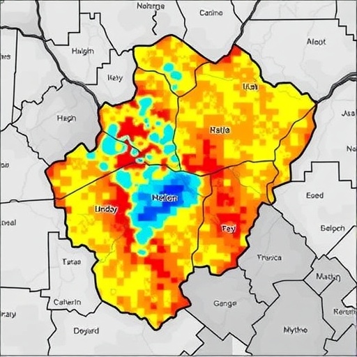
Addressing this imperative, the research team utilized Inverse Distance Weighting (IDW), a spatial interpolation technique grounded in the principle that sample points closer to one another are more alike than those farther apart. IDW allowed the researchers to generate continuous spatial distribution maps of uranium concentration from discrete groundwater sampling data across the Sahibganj District. This method was chosen for its computational efficiency and ability to capture local variation, facilitating high-resolution contamination mapping critical for targeted remediation efforts.
The dataset comprised uranium concentrations measured from groundwater wells scattered across the district, an area characterized by complex geological formations conducive to natural uranium leaching. The study’s meticulous sampling and analytical protocols ensured data reliability, crucial for the spatial interpolation to reflect actual contamination patterns. The resulting maps unveiled stark heterogeneity in uranium distribution, delineating areas of elevated risk, often correlated with geological strata containing uranium-rich minerals.
Complementing the spatial analysis, the researchers innovatively employed the entropy-weighted water quality index (EWQI), an advanced variant of traditional water quality indices. Entropy weighting integrates the information entropy concept to objectively determine the relative importance of various water quality parameters, in this case emphasizing uranium concentration alongside other physicochemical factors. This strategy overcomes the limitations of equal weighting systems by reflecting the uncertainty and variability inherent in the data, thus providing a more nuanced assessment of groundwater suitability for consumption.
The application of EWQI across the study area revealed a mosaic of water quality statuses. Certain locations exhibited indices indicative of safe drinking water, while others fell into categories of severe contamination, primarily driven by elevated uranium levels. This gradation underscores the critical need for differentiated management strategies, prioritizing areas for intervention, and underscores the potential health risks faced by local populations.
Importantly, this research transcends conventional environmental assessment by integrating geospatial techniques and entropy theory, marking a significant advancement in groundwater quality management. Such interdisciplinary synthesis not only enhances scientific understanding but also equips policymakers with actionable intelligence, facilitating evidence-based decisions for water safety regulations and public health initiatives.
The findings also have broader implications for regions with similar geological contexts worldwide. Naturally occurring uranium contamination is a pervasive yet often underrecognized hazard. The methodology spotlighted here could serve as a replicable model, enabling environmental agencies to preemptively identify vulnerable groundwater resources before widespread public health impacts manifest.
Additionally, the research spotlights the vital role of comprehensive monitoring networks. The spatial resolution achieved reflects the density and strategic placement of sampling points, emphasizing that adequate surveillance infrastructure is imperative for reliable environmental assessments. This underscores ongoing challenges in resource-limited settings, where enhancing sampling coverage can dramatically improve contamination mapping and risk mitigation.
By leveraging IDW coupled with entropy-weighted indices, the study provides a dual advantage: precise spatial characterization and a robust quantification of water quality integrating multiple parameters. This synergy affords a holistic understanding rarely attained in conventional assessments, positioning this approach as a blueprint for future groundwater quality investigations, particularly where radiological contaminants are involved.
From a public health perspective, the study’s revelations necessitate urgent attention to community awareness and alternative water supply solutions in identified high-risk zones. The integration of scientific data with local administrative efforts can catalyze effective risk communication, mitigation planning, and ultimately safeguard vulnerable rural populations dependent on groundwater resources.
Furthermore, this research contributes significantly to the field of environmental geoscience by demonstrating the applicability of advanced data science techniques in hydrological risk assessment. It exemplifies the merging of traditional environmental monitoring with modern analytical frameworks, enabling precision environmental management in increasingly complex and contaminated landscapes.
In conclusion, the study’s innovative fusion of spatial interpolation and entropy-weighted indexing offers a compelling template for uranium contamination assessment in groundwater. It highlights the imperative of multi-disciplinary approaches to unravel complex environmental health challenges while providing actionable insights to practitioners and decision-makers. As groundwater contamination threats escalate globally, such studies are pivotal in protecting public health and ensuring sustainable water resource utilization.
This groundbreaking investigation into Sahibganj District’s groundwater uranium scenario not only elevates scientific understanding but also establishes a proactive paradigm for environmental governance. The combination of spatial map precision and comprehensive quality indexing sets a precedent for handling radiological contaminants—a crucial frontier for future sustainable development strategies related to water security and public well-being.
Subject of Research: Spatial distribution of uranium contamination in groundwater and assessment of water quality using advanced geostatistical and entropy-based methodologies.
Article Title: Spatial mapping of uranium in groundwater using IDW and assessment via entropy-weighted water quality index (EWQI): a case study of Sahibganj District, Jharkhand.
Article References:
Srivastava, M., Srivastava, P.K., Kumar, D. et al. Spatial mapping of uranium in groundwater using IDW and assessment via entropy-weighted water quality index (EWQI): a case study of Sahibganj District, Jharkhand. Environ Earth Sci 85, 61 (2026). https://doi.org/10.1007/s12665-025-12721-3
Image Credits: AI Generated
DOI: https://doi.org/10.1007/s12665-025-12721-3
