In the rapidly evolving field of environmental earth sciences, the assessment of reservoir capacity and sedimentation dynamics is critical for the sustainable management of water resources. Recently, a groundbreaking study conducted by researchers Singh, Singh, Mathur, and colleagues has shed new light on these vital processes through the innovative application of geospatial techniques. Their work, focused on the Chohal dam reservoir, presents an in-depth evaluation of reservoir capacity alongside sedimentation rate estimates, offering a technical and methodological roadmap that could reshape how such assessments are approached globally.
Reservoirs, as pivotal components of water supply infrastructure, face continuous challenges from sediment deposition, which diminishes storage capacity and affects operational efficiency. The Chohal dam reservoir, a significant water body in its region, has experienced these issues, prompting the need for sophisticated evaluation methods. The study leverages advanced geospatial data analysis, integrating satellite imagery with digital elevation models to generate precise measurements of reservoir volume changes over time, demonstrating the potential of remote sensing technology in hydrological monitoring.
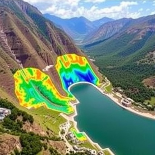
The researchers first established a baseline by gathering multi-temporal satellite data spanning several years. These data sets included high-resolution optical and radar images, which were meticulously processed to map sediment accumulation patterns. By correlating these spatial datasets with historical hydrological records, the team was able to delineate sediment deposition zones and quantify volumetric loss in the reservoir, crucially informing predictions of future storage capacity trends.
One of the key technical achievements of this research is the application of digital terrain modeling (DTM) to assess sediment thickness variations. This technique involved subtracting successive terrain elevation datasets to identify sediment build-up layers with centimeter-level precision. Such granular analysis allowed the authors to overcome traditional limitations posed by in-situ sediment sampling, which often suffers from logistical constraints and temporal delays.
Moreover, this study employed Normalized Difference Vegetation Index (NDVI) and other spectral indices to distinguish vegetation coverage and bare soil around the reservoir area. This was essential in isolating sediment sources and understanding the catchment area’s erosional dynamics. The integration of vegetation data provided a holistic perspective, linking land-use changes directly to sediment influx into the reservoir, and emphasizing the interconnected nature of ecological and hydrological systems.
The temporal dimension of sediment accumulation was also a focus, as the researchers conducted time-series analyses to monitor changes during different hydrological seasons. This facilitated the understanding of sediment flux variations related to rainfall events and anthropogenic activities, highlighting periods of intensified sediment transport and deposition within the reservoir basin.
To enhance predictive capabilities, the team developed a geospatial sedimentation model calibrated with observed sediment thickness data. This model simulates sediment behavior under various scenarios, including potential land-use alterations and climate change projections. Such forward-looking modeling is indispensable for stakeholders aiming to devise adaptive reservoir management strategies, balancing water resource demands with sediment control.
Beyond methodological advances, the implications of this research resonate deeply in the context of reservoir sustainability. Sedimentation-induced capacity reduction threatens water security, hydroelectric power generation, and flood management. The study’s findings underscore the urgency of incorporating geospatial monitoring into routine reservoir management frameworks, allowing for timely intervention measures such as dredging, catchment area management, and structural retrofitting.
This research also opens avenues for applying similar approaches to other global reservoirs facing sedimentation challenges. The transferability of the geospatial technique, validated through the Chohal dam study, illustrates a scalable and cost-effective alternative to conventional sediment assessment methods. Its non-invasive nature and capacity for frequent updates make it an ideal tool for continuous monitoring in diverse geographic settings.
An intriguing aspect of the study is its cross-disciplinary integration, merging concepts from remote sensing, geology, hydrology, and environmental management. By doing so, it bridges the gap between raw geospatial data and actionable reservoir management insights. Such integrative research models are vital for tackling complex environmental problems that transcend traditional academic boundaries.
Furthermore, the study highlights the increasing role of technology in addressing environmental challenges. The use of satellite platforms, advanced image processing algorithms, and geographic information system (GIS) tools exemplifies how cutting-edge technological resources can be harnessed to solve practical issues in water resource management. As sensor resolution and computational power continue to improve, such geospatial methodologies will become even more potent.
The authors also discuss potential limitations and challenges, including data availability constraints, the accuracy of digital elevation models in densely vegetated or rugged terrains, and uncertainties stemming from climatic variability. Acknowledging these factors is important for contextualizing the results and for guiding future improvements in methodology and data acquisition strategies.
In conclusion, the work of Singh and colleagues serves as a compelling testament to the power of geospatial techniques in environmental earth sciences. Their meticulous evaluation of the Chohal dam reservoir’s capacity and sedimentation rates provides a scientific foundation for more effective reservoir management, with wide-reaching implications for sustainability and resource conservation. This research is poised to influence future policies and technological deployments aimed at preserving critical water infrastructure worldwide.
The study not only contributes to academic knowledge but also delivers practical solutions for engineers, planners, and environmental managers. By synthesizing multiscale geospatial data with hydrological insights, this research represents a pivotal advancement in understanding and mitigating sedimentation impacts on reservoir functionality. It heralds a new era where Earth observation technologies are integral in maintaining the delicate balance between human development and natural ecosystem preservation.
As climate change intensifies and land-use pressures escalate, reservoirs like Chohal will increasingly face sedimentation stresses. This study’s innovative approach equips policymakers with the tools needed to anticipate and counteract these pressures, safeguarding water security for future generations. The precision and adaptability of their geospatial evaluation method are likely to inspire further research and technological innovation in this critical field.
For scientists and water resource managers alike, the findings from the Chohal dam case study provide both inspiration and a blueprint for action. The integration of remote sensing analytics with traditional reservoir monitoring stands out as a best practice model, illustrating how interdisciplinary cooperation can produce groundbreaking insights and tangible benefits for environmental management and societal welfare.
This publication marks a significant stride forward and invites the broader scientific community to leverage geospatial technology in confronting the multifaceted challenges of reservoir sedimentation. In doing so, it contributes to a global effort to secure water resources amidst evolving environmental and socio-economic landscapes.
Subject of Research: Reservoir capacity evaluation and sedimentation rate analysis using geospatial techniques
Article Title: Evaluating reservoir capacity and sedimentation rates using geospatial technique: a case study of Chohal dam reservoir
Article References:
Singh, J., Singh, M.C., Mathur, A. et al. Evaluating reservoir capacity and sedimentation rates using geospatial technique: a case study of Chohal dam reservoir. Environ Earth Sci 84, 391 (2025). https://doi.org/10.1007/s12665-025-12396-w
Image Credits: AI Generated
