Urban green spaces have long been heralded for their vital role in enhancing the ecological balance, moderating urban climates, and improving mental and physical well-being for city dwellers. Beyond these well-established benefits, recent studies have increasingly emphasized the economic and restorative value that diverse urban vegetation can deliver, especially through visual appeal that changes with seasons. A groundbreaking study from researchers at The University of Osaka in Japan has unveiled a sophisticated analytical framework that captures the complex temporal and spatial dynamics of urban vegetation, offering novel insights into how urban planners can optimize green spaces throughout the year.
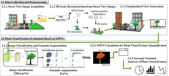
Published in the prestigious journal Landscape Ecology, this pioneering research introduces a multi-temporal vegetation visualization methodology, combining cutting-edge deep learning algorithms with 3D reconstruction techniques derived from street view imagery. The innovative integration of artificial intelligence (AI) technologies not only enhances the granularity of urban vegetation assessment but also allows dynamic modeling of plant color shifts, structural variations, and phenological stages across different seasons. This level of temporal and species-specific analysis stands as a paradigm shift from traditional green view metrics, which tend to be static and less detailed.
The core advancement lies in the creation of the Seasonal Species-Specific Plant View Index, an AI-powered system capable of distinguishing among 51 different urban plant species with impressive average identification accuracy of over 82%. This index harnesses convolutional neural networks trained on vast datasets of street-level photographic information, paired with sophisticated 3D spatial reconstruction to correct for distortions and gaps inherent in panoramic imagery. Consequently, the system can isolate plants displaying striking seasonal visual phenomena—such as the ephemeral cherry blossoms of spring and the fiery hues of maple foliage in autumn—enabling a nuanced appreciation of urban botanical diversity.
The team, led by Anqi Hu and senior researcher Tomohiro Fukuda, selected Suita City in Osaka Prefecture as their urban laboratory to validate the framework. By deploying sensors and computational processing pipelines, they generated standardized viewpoints that can automatically adjust over temporal sequences and spatial coordinates. This approach surmounts the issues of inconsistent coverage and perspective distortion in street imagery, ensuring robust and uniform data for plant species identification and seasonal visualization. Such precision is critical for urban designers who aim to orchestrate greenery arrangements that reinforce biodiversity while maximizing aesthetic pleasure year-round.
One of the remarkable implications of this technological breakthrough lies in its applicability to the restoration of brownfield sites, often characterized by heterogeneous and neglected landscapes. The framework’s capacity to virtually simulate and visualize diverse plant species over time equips planners with a powerful tool to redesign and revitalize marginalized urban areas. By strategically introducing species with complementary growth patterns, colors, and ecological functions, it is possible to foster greener, more resilient, and visually vibrant environments that contribute to urban sustainability and inhabitant well-being.
Furthermore, the approach elevates the concept of 4D urban design, where the dimension of time is embedded into spatial planning processes. This multi-temporal perspective allows the anticipation of phenological transitions and their impact on urban aesthetics and ecological services. In practice, the methodology facilitates scenario modeling that can predict how different vegetation assemblages will evolve across seasons, informing maintenance schedules, planting strategies, and public engagement efforts. Beyond ecological modeling, it reinforces a symbiotic relationship between nature and human experience in the urban milieu.
The integration of AI-driven deep learning with 3D reconstruction also signals a broader shift in how urban ecological data is collected and interpreted. Traditional remote sensing tools often lack the spatial resolution or temporal frequency required for species-specific monitoring in complex urban contexts. In contrast, street view imagery, ubiquitously available and frequently updated, provides rich, high-resolution visuals that, when analyzed with sophisticated AI tools, reveal intricate vegetation patterns that were previously hidden. This democratization of urban ecological data leverages existing technologies for scalable, cost-effective green space management.
Hu highlights that color diversity and species richness significantly enhance the psychological benefits derived from urban green spaces, contributing to what she terms the ‘feel-good’ factor. By enabling planners to visualize these variables dynamically, the new framework paves the way for creating multifunctional urban landscapes that resonate with human emotions and ecological imperatives. This aligns with growing evidence that well-designed green spaces mitigate stress, foster social interaction, and promote physical activity, thereby improving overall quality of life in dense metropolitan areas.
Another technical triumph of this research is its ability to automate the generation of consistent viewpoints in both spatial and temporal domains. This is particularly valuable for longitudinal studies aiming to track urban vegetation changes over months or years, permitting the systematic evaluation of urban greening initiatives and natural phenological cycles. Such automation minimizes the labor-intensive nature of manual data collection and increases the reliability of monitoring programs, providing urban ecologists and planners with actionable intelligence.
The study’s findings and tools hold the promise of revolutionizing urban landscaping, creating greener cities that are not only ecologically healthier but also aesthetically richer and emotionally rewarding. The fusion of AI, 3D spatial analytics, and seasonal dynamics sets a new benchmark for urban environmental research and practice. It also opens up pathways for integrating citizen science and participatory planning, where community members can visualize and contribute to the greening process, fostering shared stewardship of urban natural assets.
In an era where urban expansion often threatens ecological integrity, this research underscores the importance of innovative technological solutions to sustain and amplify urban biodiversity. By meticulously mapping how plant species distribute, evolve, and influence cityscapes through time, the work from Osaka University offers a scalable, precise, and dynamic toolkit that meets both scientific and societal needs. Its implications extend to public health, urban policy, and sustainable development, making it a landmark contribution to contemporary urban ecology.
As cities worldwide grapple with climate change challenges, environmental degradation, and social inequities, the ability to design, monitor, and adapt green spaces with such forward-looking precision is invaluable. This new AI-driven framework enriches the urban planning arsenal, ensuring that green infrastructure can be optimized to deliver ecosystem services, economic benefits, and human happiness simultaneously. Ultimately, it exemplifies how the intersection of technology, ecology, and design can inspire more harmonious and resilient urban futures.
Subject of Research: Not applicable
Article Title: Multi-temporal Analysis of Urban Vegetation Using Deep Learning and 3D Reconstruction
News Publication Date: 1-Jul-2025
Web References:
https://doi.org/10.1007/s10980-025-02090-4
Image Credits: 2025 Anqi Hu et al., Landscape Ecology
Keywords:
Social sciences, Urban planning, Urbanization, Land management, Land use, Cities, Species diversity, Species richness, Quantitative modeling, Sustainability
