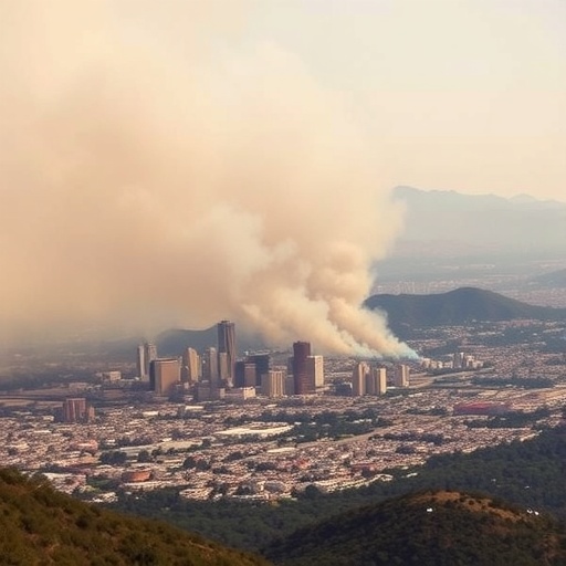
In the early weeks of 2025, Southern California faced an unprecedented environmental crisis as devastating wildfires ravaged large swaths of Los Angeles County. These fires, fueled by prolonged dry conditions and high winds, consumed tens of thousands of homes and businesses, displacing residents and severely impacting public health. One of the most immediate and insidious hazards arising from these wildfires was the dense smoke that enveloped the region, dramatically degrading air quality and posing significant respiratory risks. The rapid dissemination of timely air quality information during this period became critical for residents seeking to protect themselves from harmful pollutant exposure.
Recognizing the urgent need for accurate and accessible data, various platforms sprang into action, offering near-real-time updates on local air quality. These digital tools relied primarily on three distinct data sources: federal air quality monitoring stations operated by the Environmental Protection Agency (EPA), networks of low-cost particulate matter sensors distributed throughout the area, and satellite observations capturing smoke plume dynamics from above. However, until recently, the extent to which these disparate data streams aligned and complemented each other had not been rigorously analyzed. A groundbreaking study published in Environmental Science & Technology Letters has now provided a comprehensive comparative analysis of these datasets, revealing critical insights into their interplay and collective value.
The study, led by atmospheric scientist Claire Schollaert and her team, centered on the infamous Eaton and Palisades wildfires that broke out in early January 2025. Drawing upon measurements collected between January 7 and 12, the researchers compiled PM2.5 (fine particulate matter) concentration data from eight EPA monitoring stations strategically placed across Los Angeles County. These federal stations are renowned for their precision and rigorous calibration protocols, but their limited spatial density means they may miss localized pollution hotspots. To address this limitation, the study incorporated data from a sprawling network of 728 low-cost sensors, which, despite exhibiting reduced individual accuracy, provide a more granular spatial resolution of air quality conditions.
Satellite-based observations offered a complementary vantage point, enabling visualization of smoke plume morphology, density, and transport patterns throughout the fire event. The National Oceanic and Atmospheric Administration’s (NOAA) Hazard Mapping System, in particular, provided valuable smoke outline data, although this information is not yet fully integrated into terrestrial air quality platforms widely used by the public. By juxtaposing satellite imagery with ground-level measurements, the team sought to evaluate the fidelity and limitations inherent to each data source.
Analysis revealed that EPA stations recorded elevated PM2.5 concentrations predominantly in central urban locations such as downtown Los Angeles and Compton. These readings corresponded to “Unhealthy” and “Unhealthy for Sensitive Groups” categories on the Air Quality Index (AQI), underscoring severe air pollution episodes in those densely populated areas. Meanwhile, low-cost sensors situated within approximately 7.5 kilometers of active fire zones frequently registered PM2.5 levels reaching into the “Hazardous” AQI range. This localized intensity likely reflects the proximity effect of wildfire smoke, emphasizing the importance of dense sensor networks for capturing spatial variability in pollutant exposure.
Satellite data generally corroborated surface measurements by depicting extensive plumes of smoke with varying optical density traversing the atmosphere over affected regions. However, the study highlighted discrepancies wherein satellite smoke density did not always correspond precisely with surface pollutant concentrations. Such divergence may stem from factors including vertical smoke layer stratification, meteorological conditions, and temporal differences between satellite overpasses and ground monitoring intervals.
A key conclusion of the research is that no single data source can fully represent real-time air quality during complex wildfire events. EPA monitors provide gold-standard accuracy but lack the spatial coverage to detect micro-scale pollution patterns. Low-cost sensors boast extensive geographic distribution but are subject to calibration uncertainties and environmental interferences. Satellites deliver broad, synoptic views impossible to achieve from terrestrial assets alone, yet their data often require sophisticated interpretation and are constrained by orbital schedules and atmospheric conditions.
The synergistic integration of these diverse datasets emerges as the most promising strategy to present the public with comprehensive, actionable air quality intelligence. By leveraging the strengths of each technology—accuracy from federal monitors, fine spatial granularity from sensor networks, and expansive spatial context from satellites—authorities can develop dynamic, responsive mapping tools. Such tools empower communities exposed to wildfire smoke to make informed decisions about outdoor activities, protective measures, and health interventions in near real time.
Furthermore, the study’s retrospective approach underscores the potential for refining future air quality monitoring frameworks. Incorporating satellite-derived products into platforms like the EPA’s AirNow Fire and Smoke Map could fill existing informational gaps. Similarly, rigorously validating and standardizing data from low-cost sensors will enhance their reliability as supplementary resources. This multifaceted, data-driven perspective is crucial as climate change intensifies wildfire frequencies and severities, exacerbating air pollution episodes globally.
From a public health standpoint, understanding and communicating wildfire smoke exposure risks hinge on accurate, accessible AQI metrics, particularly those capturing fine particulate matter, which penetrates deep into the respiratory tract. The alignment of advanced monitoring infrastructures with epidemiological insights can guide targeted advisories and resource allocation for vulnerable populations. Real-time air quality communication tools thus become vital instruments in safeguarding lives amid escalating environmental hazards.
This pioneering work was funded in part by the Gordon and Betty Moore Foundation and the Climate and Wildfire Research Initiative at UCLA. Their support facilitated a multidisciplinary collaboration integrating atmospheric chemistry, environmental engineering, and data science expertise. The findings not only advance scientific knowledge but also exemplify how public data sources, when judiciously combined, can bolster community resilience in the face of natural disasters.
Looking ahead, technological innovations such as machine learning algorithms may enhance the fusion of heterogeneous air quality data streams, producing predictive models with improved temporal and spatial resolution. Coupling these advancements with mobile applications and social media dissemination strategies holds promise for expanding public engagement and awareness. As urban areas worldwide contend with wildfire threats, deploying holistic monitoring systems rooted in this research will be paramount.
In conclusion, the January 2025 Los Angeles wildfires illuminated both the challenges and opportunities inherent in monitoring and communicating air quality during catastrophic events. By harnessing federal monitoring precision, ubiquitous sensor contributions, and satellite observational power, stakeholders can transcend traditional data silos. This integrated approach not only enriches environmental intelligence but ultimately fortifies public health defenses against the invisible, yet pernicious, impact of wildfire smoke.
Subject of Research: Air quality impacts and monitoring during the January 2025 Los Angeles wildfires
Article Title: “Air Quality Impacts of the January 2025 Los Angeles Wildfires: Insights from Public Data Sources”
News Publication Date: 14-Jul-2025
Web References: http://dx.doi.org/10.1021/acs.estlett.5c00486
Keywords
Wildfires, Air Quality, PM2.5, Environmental Monitoring, Satellite Remote Sensing, Low-Cost Sensors, EPA AirNow, Smoke Plumes, Public Health, Data Integration, Los Angeles, Atmospheric Pollution
