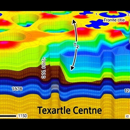
In northern Thailand, a region notorious for its intricate geology and active fault systems, frequent landslides pose significant risks to lives and critical infrastructure. In 2022, a major slope failure occurred along Highway No. 1088 in Chiang Mai Province, prompting a comprehensive geotechnical investigation led by Professor Shinya Inazumi from the Shibaura Institute of Technology (SIT), Japan. The research team aimed to identify the underlying causes of the collapse, yet faced an inherent challenge: while 2D electrical resistivity imaging (ERI) offered extensive coverage of the entire slope, borehole data—a traditional source for precise subsurface information—were limited to just a few survey lines. This disparity created substantial uncertainties in defining soil layer boundaries, differentiating geomaterials, and evaluating relative stiffness within the failure zone.
Conventionally, boreholes provide invaluable data on soil properties, but their deployment is costly, time-consuming, and often impractical in difficult terrains such as mountainous regions. These limitations restrict the spatial resolution of subsurface characterization, leading to incomplete understanding of landslide-prone areas. Professor Inazumi and his team recognized the need for innovative approaches that could bridge the data gap, enhancing both efficiency and reliability in geotechnical surveys.
Recent advancements in machine learning presented promising tools for identifying patterns and correlations within complex geophysical datasets. Leveraging these capabilities, the research team developed a novel integrative framework combining 2D ERI results with sparse borehole data through k-means clustering algorithms. This method enabled effective estimation of soil stiffness parameters, specifically the N₆₀-values, across broad areas with minimized reliance on extensive drilling.
By strategically utilizing data from only four boreholes supplemented with 2D ERI, the team derived a robust power-law equation correlating electrical resistivity measurements to soil stiffness, boasting a high coefficient of determination (R² = 0.9467). This relationship was further validated for accuracy, with mean absolute error (MAE) and root mean square error (RMSE) values of 3.94 and 5.21, respectively, demonstrating the model’s reliability in predicting geotechnical parameters critical for slope stability assessments.
The machine learning component proved pivotal in classifying subsurface materials into three distinct competence categories—low competency represented by loose sand, moderate competency including medium-stiff clay, and high competency encompassing stiff to hard clay. This classification scheme facilitates precise mapping of soil heterogeneity and identification of potential weak zones that might be susceptible to failure under stress.
Professor Inazumi emphasized the transformative potential of this methodology in reducing the operational role of borehole drilling. Beyond cost savings, the approach significantly diminishes environmental impacts linked to soil disturbance, surface degradation, and groundwater contamination often associated with traditional invasive methods. More importantly, the continuous spatial data generated through resistivity imaging integrated with machine learning allows comprehensive subsurface profiling, superseding isolated point observations from boreholes.
The implications for infrastructure engineering and disaster risk management are profound. Highway authorities can employ this technique to monitor soil stability along critical transport corridors, detecting vulnerable segments prone to landslides, as evidenced by the study’s focus on Highway No. 1088. Construction projects benefit from optimized foundation designs, balancing safety and cost by accurately delineating areas of varying soil strength.
Moreover, the framework is ideally suited for challenging geographies, such as mountainous and faulted terrains where accessibility hinders exhaustive drilling campaigns. Governmental agencies tasked with landslide hazard mapping can leverage these findings to formulate proactive slope stabilization strategies, potentially averting catastrophic events. Dam engineers gain the ability to assess seepage and embankment integrity without compromising structural elements through excessive drilling.
Municipal planners and urban developers also stand to gain from adopting this advanced geophysical-machine learning integration. Preliminary site investigations become more cost-effective and less time-intensive, with focused borehole drilling reserved only for locations flagged as critical by resistivity-driven analysis. Emergency management organizations can harness regional subsurface strength maps generated by this approach to evaluate liquefaction risks in seismic zones, bolstering infrastructure resilience in the face of natural disasters.
This breakthrough represents a significant leap forward in geotechnical practice, demonstrating how data-driven techniques can overcome the inherent constraints of traditional methods. By fusing electrical resistivity imaging with machine learning analytics, researchers have unveiled a scalable, practical tool for comprehensive subsurface characterization that balances precision, efficiency, and environmental stewardship.
In summary, Professor Inazumi’s pioneering work exemplifies the convergence of geophysical sensing, data science, and engineering expertise to address complex geotechnical challenges. Facilitating robust characterization of soil properties over expansive and difficult terrains, this integrated framework is poised to become a vital asset in landslide mitigation, infrastructure development, and natural hazard preparedness worldwide.
Subject of Research: Not applicable
Article Title: Using 2D electrical resistivity imaging and borehole data to estimate N60-value of soils with k-means clustering for subsurface geomaterials categorization
News Publication Date: 26-Sep-2025
References: DOI: 10.1016/j.jrmge.2025.05.030
Image Credits: Institute of Rock and Soil Mechanics, Chinese Academy of Sciences
Keywords: Geophysics, Earth sciences, Machine learning, Artificial intelligence, Applied sciences and engineering
