In the shadow of the Mendenhall Glacier near Juneau, Alaska, an evolving natural phenomenon has increasingly captured the attention of scientists, emergency managers, and the local community alike. Glacier-induced flooding, originating from the periodic release of water trapped within glacier-dammed lakes, has become a growing threat over the past decade. The U.S. Geological Survey (USGS), in collaboration with numerous agencies including the City and Borough of Juneau, the Alaska Department of Transportation and Public Facilities, and the U.S. Army Corps of Engineers, has been at the forefront of monitoring and understanding these complex hydrological events using cutting-edge technologies and real-time data collection systems.
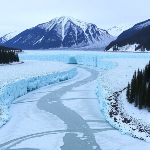
At the core of this emerging risk is Suicide Basin, a side basin of the larger Mendenhall Glacier system. Glacier-dammed lakes like Suicide Basin form when advancing or stable glaciers block natural valley drainage, creating reservoirs that can accumulate enormous volumes of water. When these ice dams weaken or fail, catastrophic floods are unleashed downstream, posing risks to infrastructure, ecosystems, and human settlements. Since 2011, annual flood events emanating from this region have demonstrated unprecedented volumes and intensities, surpassing historical records and inundating over 300 homes in recent years, thereby challenging traditional flood management approaches in alpine and glacial environments.
To mitigate these hazards, the USGS has implemented a comprehensive monitoring network centered on real-time data acquisition. This setup includes strategically positioned high-resolution cameras and a state-of-the-art laser measurement system to continuously track water and ice level fluctuations within Suicide Basin. By capturing dynamic changes in the glacier and its adjacent hydrologic features, the system allows for detailed temporal analysis of lake volumes and dam integrity. This data is relayed in near-real-time to stakeholders and emergency management teams, enabling rapid response measures well before floodwaters translate into downstream impacts.
Jeff Conaway, a lead scientist with the USGS Alaska Science Center, highlights the critical role of this technological infrastructure: “Our real-time monitoring equips emergency officials with advanced notice to initiate evacuations and road closures, potentially saving lives and reducing property damage.” This insight epitomizes the fusion of environmental science and public safety protocols, as data-driven decisions become paramount in managing natural hazards exacerbated by climate variability and glacier dynamics.
The National Weather Service (NWS) leverages the USGS monitoring data to forecast flood timing and magnitude with enhanced accuracy. Integration of observational inputs from the cameras and laser sensors into hydrological and meteorological models allows forecasters to simulate potential scenarios of flood evolution, providing vital information for risk assessment and emergency planning. This collaboration represents a model example of inter-agency cooperation harnessing scientific data to serve community resilience in the face of natural disasters.
Downstream river conditions receive equal scrutiny. The USGS operates a streamgage on Mendenhall Lake, capturing water temperature and lake elevation data every fifteen minutes. This high-frequency data serves a dual purpose: discerning glacier lake floodwater release from conventional rainfall runoff, as glacier-derived water often manifests as cooler due to its origin, and quantifying lake level trends linked to flood risk. Such precise monitoring aids in the early detection of flood triggers, facilitating timely warnings and response protocols.
Beyond Mendenhall Lake, three additional streamgages installed on bridges spanning the Mendenhall River measure water height and flow velocities in real time. These instruments are critical in tracking flood wave progression and intensity, offering direct measurements that complement upstream lake monitoring. Complementing the gauges, high-definition webcams provide visual confirmation and situational awareness of river conditions, enhancing the qualitative understanding of flood dynamics during events.
Post-flood assessments include measuring river channel morphology, particularly river bottom depths beneath bridge structures. These surveys are essential to evaluate potential scouring effects caused by floodwaters, phenomena that can undermine structural integrity and dictate the safety of bridge reopening decisions. This process embodies adaptive infrastructure management, where empirical data guides recovery and resilience strategies.
The integration of these multiple datasets into a comprehensive monitoring framework exemplifies a multidisciplinary approach to natural hazard management. Resource managers and emergency responders not only utilize this data to protect human life and property but also apply findings to refine hydrological models and assess the efficacy of engineered flood control measures along the Mendenhall River corridor. This adaptive management strategy is increasingly vital as glacier dynamics respond to climate change, altering flood regimes unpredictably.
The rising frequency and magnitude of glacier lake outburst floods in Suicide Basin are the embodiment of changing environmental conditions in high-latitude glacial systems. The ongoing monitoring by the USGS spans over 130 years of hydrological observation tradition, albeit with modern instrumentation that enriches data quality and usability. These data streams feed into broader environmental assessment programs encompassing water supply management, infrastructure design, flood risk evaluation, and recreational safety in glacier-influenced river systems.
In conclusion, the USGS’s real-time monitoring and inter-agency collaborations represent a landmark effort in addressing glacier lake outburst flood hazards. This sophisticated application of laser-based water level gauging, paired with visual surveillance and streamflow measurements, provides an actionable knowledge base. It ensures that emergency responses in Juneau are informed, timely, and effective, buffering the community against an increasingly volatile natural environment shaped by glacier evolution and climatic shifts.
Subject of Research: Glacier lake outburst floods, hydrological monitoring, glacier dynamics, flood risk management
Article Title: Advancing Glacier Flood Forecasting: Real-Time Monitoring at Suicide Basin, Alaska
News Publication Date: Not specified
Web References:
- USGS HIVIS monitoring: https://apps.usgs.gov/hivis/?text=Mendenhall
- National Weather Service flood forecasts: https://www.weather.gov/ajk/suicidebasin
Image Credits: USGS
Keywords: Flood control, Glaciers, Natural disasters, Climate change, Hydrology, Ice, Water resources, Information processing
