In a groundbreaking study conducted by a research team led by Prof. Yue-Ren Xu at the Institute of Earthquake Forecasting within the China Earthquake Administration, the utilization of high-resolution satellite imagery has been highlighted as a revolutionary approach in assessing surface ruptures following significant seismic events. This study specifically targets the effects of the 2023 Türkiye earthquake doublet, a notable geological occurrence that struck southeastern Türkiye and northwestern Syria on February 6, 2023.
The earthquakes, recognized as the Pazarcık and Elbistan earthquakes, measured magnitudes of 7.8 and 7.5, respectively, shaking the region with profound intensity. The Pazarcık earthquake was recorded at 1:17 A.M. GMT, with a focal depth of 10 kilometers. Just nine hours later, the Elbistan earthquake followed, occurring at a shallower focal depth of 7.4 kilometers. Both seismic events resulted in extensive surface ruptures, leading to significant scientific inquiry into their geophysical impacts.
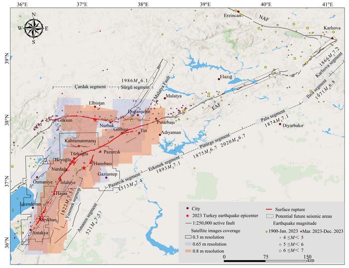
The capacity to rapidly acquire detailed satellite images in the aftermath of these earthquakes has proven invaluable. The research team employed an array of high-resolution satellite data, including resources from Chinese GF-series satellites (GF-2/7), Beijing satellites (BJ-2/3), and various Maxar satellites. These images, with resolutions ranging between 0.3 to 0.8 meters, enabled the researchers to analyze the characteristics of surface ruptures comprehensively. As a result, they discerned that the two earthquakes produced distinct rupture zones, providing essential insights into their individual geological phenomena.
The first earthquake showcased a remarkable coseismic surface rupture extending approximately 280 kilometers along the southwestern segment of the main East Anatolian Fault. This surface rupture was characterized by left-lateral displacements, with measurements revealing shifts reaching up to 6.8 ± 0.68 meters, particularly pronounced 40 kilometers northeast of the event’s epicenter. Conversely, the second earthquake’s rupture exhibited a shorter duration, generating a rupture of about 110 kilometers along an east-west branch of the fault, with maximum displacements recorded at 7.2 ± 0.72 meters. Such findings underscore the varied geological behaviors exhibited by these two seismic events.
Further analysis conducted by Xu’s research group involved juxtaposing the surface rupture distributions and displacement data obtained from high-resolution satellite imagery against results sourced from InSAR and ground-based field measurements. Through this comparative methodology, the researchers concluded that rapid assessments employing high-resolution remote sensing data could significantly enhance scholarly understanding of surface rupture characteristics. Such tools offer scholars and earthquake scientists the ability to comprehend the impacts of seismic events in foreign territories swiftly.
Moreover, the study presents critical observations regarding the nature of cascading ruptures. The research team’s findings reveal that the surface rupture behavior does not adhere strictly to established recurrence intervals, proposing that maximum surface slip is influenced by the accumulative stress energy present within each fault segment. Interestingly, they noted that despite the greater magnitude of the Pazarcık earthquake, its maximum surface offset was surpassed by that of the subsequent Elbistan earthquake. This nuanced understanding of rupture dynamics elucidates the complexity underlying seismic events and challenges previous assumptions held within the earthquake research community.
Additionally, Prof. Xu’s article sheds light on historical seismic activity within the region. He emphasized that the 1822 event, recorded as a Magnitude 7.5 earthquake, likely occurred along the Yesemek segment, rather than along the Amanos segment, which helped prevent the propagation of rupture southward along the Narlı segment during the major Pazarcık earthquake event. By identifying these nuanced historical patterns, his research emphasizes the importance of studying past events to better predict future seismic activities.
The potential implications of these findings extend beyond academic discourse, raising concerns regarding the seismic risks associated with areas such as the Malatya Fault and specific segments of the East Anatolian Fault. The research underscores the necessity of enhancing seismic fortification measures, particularly in valley regions adjacent to these fault segments, which may remain susceptible to future earthquakes. Such fortification efforts can serve as crucial preventive measures aimed at safeguarding the local populations and infrastructures against the disastrous impacts of future seismic events.
The pursuit of knowledge surrounding earthquake rupture mechanisms continues to evolve, propelled by advancements in remote sensing technology. The study led by Xu not only exemplifies the significant role of high-resolution satellite imagery in evaluating seismic occurrences but also highlights the collaborative nature of global scientific inquiry. By sharing their findings, Prof. Xu’s team contributes to a broader understanding of earthquake dynamics that can pave the way for future studies in earthquake preparedness and disaster management strategies.
This pioneering research signifies a noteworthy advancement in the field of earthquake research. It emphasizes the important intersection between technology and geology, highlighting how satellite imagery can facilitate rapid assessments post-disaster while promoting the understanding of complex geophysical processes. As researchers continue to refine these methodologies, the hope is that a greater comprehension of earthquake phenomena will emerge, ultimately fostering improved preparedness against the ever-looming threat of seismic activity.
In conclusion, the study instills a greater understanding of the urgent need for comprehensive examinations of earthquake effects and the geological processes behind them. By recognizing the intricate dynamics of fault ruptures, society can adopt a forward-looking approach, preparing to mitigate the impacts of significant seismic events through scientific innovation and thorough research.
Subject of Research: High-resolution satellite data assessment of surface ruptures in the 2023 Türkiye earthquake doublet.
Article Title: Rapid Assessment of Surface Ruptures in the 2023 Türkiye Earthquakes Using High-Resolution Satellite Data
News Publication Date: October 2023
Web References: N/A
References: N/A
Image Credits: ©Science China Press
Keywords: earthquake, satellite imagery, surface rupture, seismic risks, 2023 Türkiye earthquake, earthquake assessment, high-resolution data, East Anatolian Fault, cascading rupture patterns, seismic fortification.
