


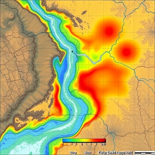
In one of the most closely watched developments in applied geospatial artificial intelligence, a research team based at Yanbian University in northeastern China has demonstrated that machine learning models can be trained in a data-rich region and successfully transferred across a heavily secured international border to produce reliable flood susceptibility maps where no local flood inventory exists. The study, led by Yuxuan Zhou with corresponding author Hechun Quan, along with Weihong Zhu, Ri Jin and Guangri Jin, focuses on the Tumen River Basin, a transboundary watershed that flows along and across the China–North Korea border and drains roughly 33,000 square kilometers of mountainous terrain in Northeast Asia. The work, published in the journal Natural Hazards, addresses a problem that has long frustrated disaster scientists: how to produce credible hazard assessments in regions where ground-based observational data are scarce, restricted or simply unavailable.
Flood susceptibility mapping differs from flood forecasting in an important technical sense. Rather than predicting when a flood will occur, susceptibility analysis answers a spatial question: which parts of a landscape are inherently most prone to flooding given their topography, geology, hydrology, land cover and climatic context. The standard approach requires two classes of labeled data: a set of geo-referenced flood occurrence points, typically compiled from historical disaster records, satellite imagery and field surveys, and an equal set of non-flood points sampled from areas that have remained dry. These labels are paired with a stack of conditioning factors, and a supervised learning algorithm is trained to discriminate between the two classes. The trained model is then applied pixel by pixel across the landscape to generate a continuous susceptibility surface, usually binned into classes from very low to very high.
The Chinese side of the Tumen River Basin offered the team a workable data environment. The researchers assembled 143 flood points and 143 non-flood points, split them with 70 percent reserved for training and 30 percent held out for independent testing, and built two families of models using gradient-boosted decision tree ensembles: Light Gradient Boosting Machine, known as LightGBM, and Extreme Gradient Boosting, known as XGBoost. These algorithms are now staples of geospatial hazard modeling because they handle nonlinear interactions among predictors, are robust to heterogeneous feature scales, and offer strong out-of-sample generalization from comparatively modest sample sizes. XGBoost builds additive trees with regularized objective functions to control overfitting, while LightGBM introduces histogram-based splitting and leaf-wise tree growth, which dramatically reduces computational cost on large raster datasets without sacrificing predictive accuracy.
Two model configurations were constructed and compared. The multi-factor model incorporated a full complement of conditioning variables, capturing the dense hydro-geomorphological detail available on the Chinese side of the basin. When applied across the Chinese portion of the watershed, this model found that very low susceptibility areas dominate the region, covering 67.71 percent of the territory, or 15,412.58 square kilometers. High susceptibility areas accounted for 10.77 percent, equivalent to 2,450.97 square kilometers, while very high susceptibility zones proved negligible. In contrast, the simplified model, built on a reduced set of factors, painted a broader and more cautionary picture: very high susceptibility zones expanded to 15.89 percent of the Chinese region, some 3,616.35 square kilometers. The researchers interpret this inflation as enhanced sensitivity under reduced-factor conditions; with fewer explanatory variables, the model’s decision boundaries widen and more terrain falls into the upper susceptibility classes.
The consistency analysis between the two model configurations revealed a striking degree of agreement despite their divergent susceptibility distributions. The two susceptibility surfaces showed a Pearson correlation coefficient of 0.7817, a mean squared error of just 0.0300, and a convolutional neural network-based similarity metric of 0.9983, indicating that the spatial patterns of the two maps are nearly identical in structure even where their absolute class assignments differ. Both simplified models achieved outstanding discrimination performance on held-out test data, with area under the receiver operating characteristic curve, or AUC, values of 0.9362 for XGBoost and 0.9384 for LightGBM. An AUC above 0.93 places both models firmly in the range conventionally described as excellent, meaning they correctly rank flood-prone locations above non-flood locations more than 93 percent of the time.
The crucial methodological innovation came next. Because the North Korean side of the basin lacks accessible flood inventories, disaster records and many of the ancillary data layers needed to train a model from scratch, the researchers did something that has become increasingly fashionable in the broader machine learning community but remains rare in transboundary hydrology: they borrowed knowledge. Transfer learning, in essence, takes a model trained on a source domain and adapts it to a target domain, exploiting the assumption that if the two domains share enough structural similarity in their feature distributions, the learned decision function will transfer with reasonable fidelity. The team transferred their validated simplified model, built on the reduced factor set available on both sides of the border, directly to the North Korean portion of the Tumen Basin, using only data layers obtainable from global remote sensing products.
The transferred model produced a flood susceptibility map for the North Korean side of the basin with results that broadly mirror the spatial logic of the Chinese-side assessment. Very low susceptibility areas accounted for 64.20 percent of the North Korean portion, or 6,828.85 square kilometers. More significantly from a disaster-preparedness standpoint, high and very high susceptibility zones together represented 19.27 percent of the North Korean region, nearly one in five square kilometers of territory. The authors argue that this constitutes reliable flood susceptibility assessment in a data-limited transboundary environment and that the approach directly supports regional flood risk management, where international cooperation is often logistically constrained and where conventional in-situ data collection is not feasible.
The significance of this work extends well beyond a single river basin. Transboundary watersheds pose persistent governance challenges precisely because hydrological processes do not respect political boundaries, but the instruments of disaster science, including gauge networks, disaster databases and high-resolution national mapping programs, almost always do. Approximately 310 international river basins are shared by two or more countries, and many of them traverse exactly the kind of data-poor, access-restricted terrain where the Yanbian team’s methodology could prove transformative. By demonstrating that a simplified model can be trained on one side of a border and applied on the other with defensible accuracy, the researchers have effectively created a template for hazard assessment in some of the world’s most politically and institutionally fragmented landscapes.
The choice of the Tumen River Basin as the test bed is also scientifically motivated. The basin has a well-documented history of damaging floods, including the severe storm flood disaster of August 2016, and its mountainous topography, monsoon-driven rainfall regime and mixed forest-agricultural land cover create strongly heterogeneous flood conditioning. Previous work by overlapping research groups at Yanbian University has applied boosting ensemble techniques to debris flow susceptibility in the same basin, and the region’s wetland dynamics and ecosystem functions have been studied extensively under combined climate change and human activity pressures. The new study builds on this accumulated regional expertise while pushing the methodological frontier toward cross-domain generalization.
Technically, the study also contributes to an ongoing debate in the flood susceptibility literature about model complexity versus robustness. Many recent studies throw dozens of conditioning factors at increasingly sophisticated algorithms, achieving high AUC scores on benchmark datasets but risking overfitting to idiosyncrasies of the training inventory. The Yanbian team’s finding that a reduced-factor model achieves essentially equivalent discrimination while exhibiting broader sensitivity, and that such a model transfers better across domains, suggests an important principle: in transfer learning scenarios, parsimony in the feature space may be a virtue rather than a compromise. Factors that are globally or regionally consistent, such as those derived from digital elevation models and open satellite products, are precisely the ones that generalize across borders, whereas locally curated datasets may inject source-domain artifacts that degrade transfer performance.
The broader implications intersect with rapid developments in machine learning for hydrology. Deep learning methods for flood mapping, hybrid modeling of the global hydrological cycle and explainable artificial intelligence approaches to susceptibility mapping are all active research fronts, and the field is converging on a consensus that data scarcity, not algorithmic capability, is now the binding constraint on global hazard assessment. The Tumen study offers a concrete answer to that constraint: when the target domain cannot provide labels, borrow a decision function from a hydrologically analogous source domain, validate it rigorously on the source side, and use only transferable, globally available covariates. The 0.7817 Pearson correlation and 0.0300 mean squared error between the multi-factor and simplified Chinese models provide an internal benchmark for how much agreement can be expected between a full-data reference model and its transferable, reduced-factor counterpart.
For the roughly two million people living in the Tumen Basin on both sides of the border, the practical payoff is a first-of-its-kind susceptibility map for the North Korean portion, identifying where floods are most likely to strike and where mitigation investment, evacuation planning and land use regulation would deliver the greatest benefit. For the international disaster science community, the message is arguably larger still: the combination of gradient-boosted ensembles, carefully pruned feature sets and cross-border transfer learning offers a scalable, low-cost pathway to hazard intelligence in exactly the regions where it has been hardest to obtain. As climate change intensifies the hydrological cycle across Northeast Asia and beyond, methods that can leap political barriers as easily as water does are likely to move from novelty to necessity.
Cite Scienmag News
Violet Maxwell. (September 8, 2026). Transfer learning maps flood susceptibility in the Tumen River Basin. Scienmag. https://scienmag.com/transfer-learning-maps-flood-susceptibility-in-the-tumen-river-basin/
Violet Maxwell. "Transfer learning maps flood susceptibility in the Tumen River Basin." Scienmag, 8 September 2026, https://scienmag.com/transfer-learning-maps-flood-susceptibility-in-the-tumen-river-basin/. Accessed 8 September 2026.
Violet Maxwell. "Transfer learning maps flood susceptibility in the Tumen River Basin." Scienmag. September 8, 2026. https://scienmag.com/transfer-learning-maps-flood-susceptibility-in-the-tumen-river-basin/


